Situation Summary
Angola remains a mid-tier global security concern (rank #54, composite score 33) with no tracked threat events in the current reporting cycle. The security environment is regionally fragmented: northern and eastern provinces face elevated risk from armed group activity, resource-driven crime, and cross-border instability, while central and southern regions remain comparatively stable. Wildfire activity across multiple provinces represents the most visible recent hazard signal, though this reflects environmental rather than security deterioration.
Key Developments
No multi-source-confirmed security, unrest, or infrastructure incidents were reported in Angola during the 24–48 hours preceding 18 July 2026. Standing risk factors remain:
- Luanda and major urban centers — Assaults on foreign nationals persist as a recurring crime concern, particularly in the capital; this is an endemic rather than acute development, but should remain on duty-of-care watchlists.
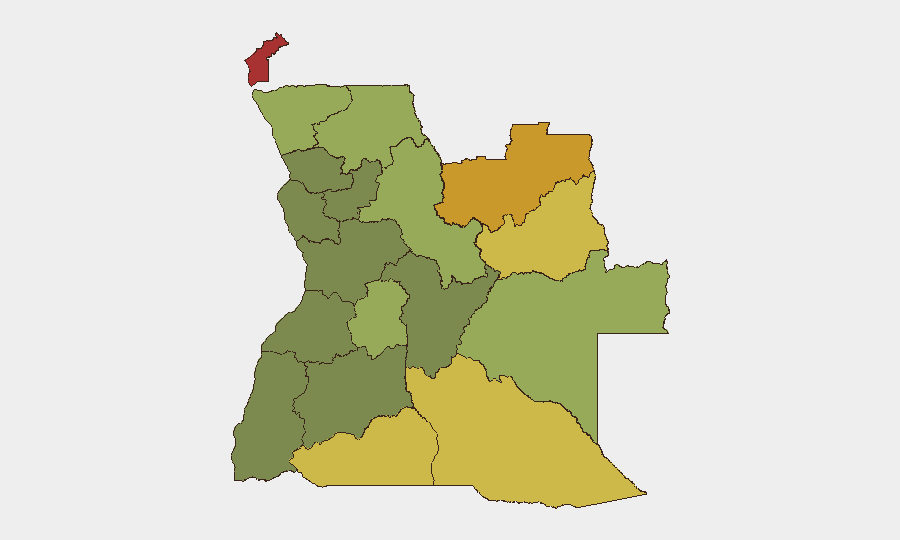
- Cabinda Province — Continued elevated risk associated with separatist activity and competition for oil-sector resources; no specific incident flagged in the immediate reporting window, but the province maintains the highest sub-national risk score (78).
- Lunda Norte and Lunda Sul provinces — Diamond-mining zones continue to attract organized crime and armed-group activity; risk scores of 72 and 68 respectively reflect persistent structural instability rather than acute escalation.
- Northern border zones (Zaire, Uíge) — Cross-border movement and trafficking activity remain elevated; no specific border incident confirmed in the last 48 hours.
- Wildfire events — Multiple fire incidents have been detected across provinces; while not security threats per se, wildfires can disrupt supply chains, damage infrastructure, and create displacement that compounds security management complexity.
Highest-Risk Areas
Cabinda, Lunda Norte, and Lunda Sul provinces drive Angola's overall threat profile, collectively scoring 78, 72, and 68. These regions share three risk drivers: (1) resource extraction industries (oil and diamonds) that attract organized crime and armed competition; (2) historical or ongoing separatist/insurgent presence; and (3) porous borders enabling cross-border trafficking and militant movement. Cuando Cubango, Cunene, and Moxico provinces (scores 64, 62, 58) extend this risk corridor along Angola's southern and eastern borders. By contrast, Bié and Huíla provinces in the south register lower risk (35, 32), making them more suitable for routine operations.
How GeoBit Would Assist
Security teams managing Angola exposure should employ AOI Monitoring & Early Warning to establish persistent watch on Cabinda and the Lunda provinces, enabling rapid alert if armed-group activity or trafficking intensity escalates. Network & Actor Analysis paired with multi-language OSINT and X/Telegram intelligence will surface emerging criminal or militant actors before they impact operations. Satellite & Imagery analysis can track wildfire progression and infrastructure damage, informing logistics and evacuation planning. Routing & Network Analysis supports safe-passage planning around high-risk zones, and regime-stability and border-dispute search provides early signals of political or cross-border deterioration.
7-Day Outlook
No acute escalation is anticipated in the near term. Wildfire activity may continue seasonally, but security indicators remain stable. However, the structural instability in northern and eastern provinces—particularly around extractive industries—warrants continuous monitoring for opportunistic criminal activity or renewed militant recruitment, especially during periods of international market volatility or border-region political shifts.
Highest-Risk Areas — Ranked
| # | State / Region | Risk |
|---|---|---|
| 1 | Cabinda Province | 78 |
| 2 | Lunda Norte Province | 72 |
| 3 | Lunda Sul Province | 68 |
| 4 | Cuando Cubango Province | 64 |
| 5 | Cunene Province | 62 |
| 6 | Moxico Province | 58 |
| 7 | Zaire Province | 54 |
| 8 | Huambo Province | 50 |
| 9 | Uíge Province | 48 |
| 10 | Malanje Province | 42 |
| 11 | Bié Province | 35 |
| 12 | Huíla Province | 32 |
Sources
Previous Daily Briefs
A new Angola brief is written every day — each with its own risk map and downloadable CSV. Here's the last week; use the calendar to go further back.
📅 Browse every day by calendar →
Highlighted days have a brief. Tap a day for that day's map & analysis, or “csv” for that day's dataset ($5).
Atlas — our AI intelligence desk — emails them this snapshot personally. Nothing else, no list.