Situation Summary
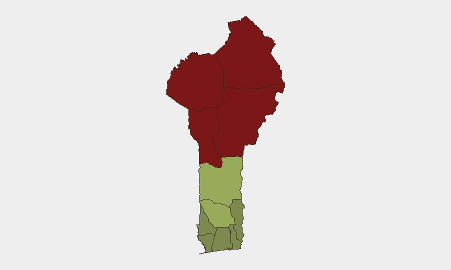
Benin remains classified at moderate global threat rank (#58, composite score 30), with insurgency and terrorism as the primary risk driver, though no discrete security incidents were confirmed in the last 24–48 hours. The northern departments (Alibori, Atakora, Donga, and Borgou) continue to dominate the threat landscape, driven by persistent spillover from jihadist activity in the Sahel region and cross-border militant movement from Niger and Burkina Faso. Southern and coastal regions maintain significantly lower risk profiles. The overall security posture remains stable but volatile in the far north, with no indication of imminent escalation.
Key Developments
No new security incidents in Benin were sufficiently corroborated from reliable sources in the last 24–48 hours to report as current developments. Web and social-media results available for analysis did not yield cross-confirmed reports of fresh conflict activity, terrorism events, civil unrest, crime spikes, or infrastructure disruption dated to 6–7 August 2026.
—*Note: This reflects data constraints, not an absence of risk. Northern Benin remains under active threat from jihadist groups; lack of reported incidents does not indicate reduced underlying threat.*
Highest-Risk Areas
Alibori, Atakora, Donga, and Borgou departments form a contiguous high-risk arc across northern Benin, with composite scores ranging from 92 to 83. This zone is the primary nexus of insurgency and terrorism risk, driven by documented jihadist presence, cross-border infiltration, and competition for ungoverned space along Benin's borders with Niger and Burkina Faso. Zou (45) and Collines (42) represent a secondary tier of moderate risk, likely reflecting trafficking, criminal networks, and latent spillover effects. The southern tier—Plateau, Kouffo, Mono, Atlantique, Littoral, and Ouémé—remains substantially lower-risk, with scores between 22 and 38, though urban crime and petty security issues persist in commercial hubs.
How GeoBit Would Assist
Corporate security teams with personnel or assets in Benin should employ AOI (Area-of-Interest) Monitoring & Early Warning focused on Alibori, Atakora, Donga, and Borgou departments to detect emerging militant activity, roadblock incidents, or cross-border incursions in near real-time. OSINT Fusion & Corroboration (X/Twitter, Telegram, local news, and multi-language social signals) combined with Conflict & Military tracking (force structure, weapons movement, battle mapping) will enable continuous situational awareness and early detection of jihadist operations or military responses. For personnel operating in the north, Routing & Network Analysis should be used to plan secure travel corridors and identify alternative supply/evacuation routes that avoid high-threat zones.
7-Day Outlook
No escalation indicators are evident in the current reporting window; the northern threat posture is likely to remain at present baseline levels over the next 7 days. However, the Sahel region's ongoing instability and Benin's porous northern borders mean that opportunistic militant activity or cross-border incursions can occur with limited warning. Duty-of-care teams should maintain heightened alertness in the four northern departments and continue active intelligence monitoring through the week.
Highest-Risk Areas — Ranked
| # | State / Region | Risk |
|---|---|---|
| 1 | Alibori Department | 92 |
| 2 | Atakora Department | 88 |
| 3 | Donga Department | 85 |
| 4 | Borgou Department | 83 |
| 5 | Zou Department | 45 |
| 6 | Collines Department | 42 |
| 7 | Plateau Department | 38 |
| 8 | Kouffo Department | 35 |
| 9 | Mono Department | 32 |
| 10 | Atlantique Department | 28 |
| 11 | Littoral | 25 |
| 12 | Ouémé Department | 22 |
Sources
Previous Daily Briefs
A new Benin brief is written every day — each with its own risk map and downloadable CSV. Here's the last week; use the calendar to go further back.
📅 Browse every day by calendar →
Highlighted days have a brief. Tap a day for that day's map & analysis, or “csv” for that day's dataset ($5).
Atlas — our AI intelligence desk — emails them this snapshot personally. Nothing else, no list.