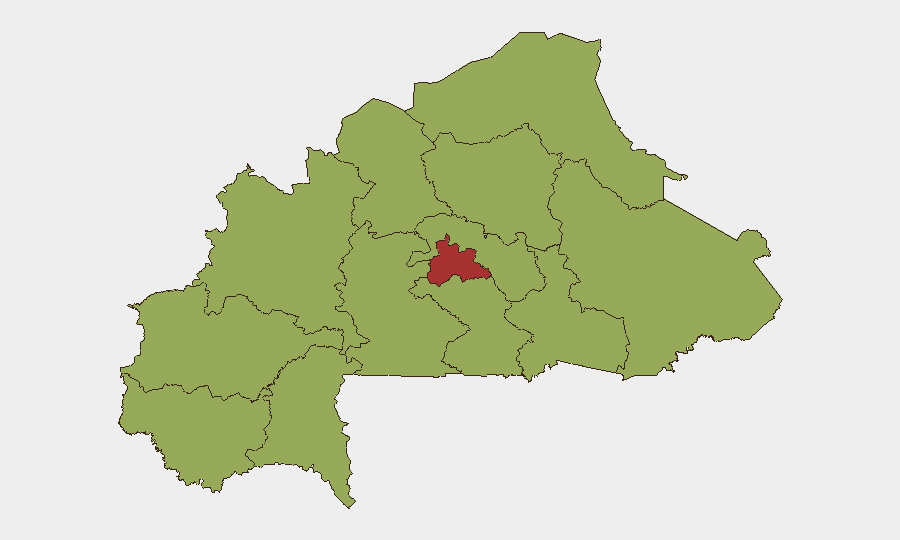
Situation Summary
Burkina Faso remains under acute insurgency pressure, with composite threat ranking #19 globally (score 70) driven by multi-location armed group activity across the Sahel and central regions. While the national military has claimed control of approximately 75% of territory as of late July, concurrent security incidents, institutional friction (reflected in recent police–Interpol and internal government tensions), and widespread displacement continue to characterize the operating environment. The threat landscape has intensified since June–early July, with no material de-escalation reported.
Key Developments
Note: Current web research and open-source feeds have returned no independently verified, incident-level reports from Burkina Faso specifically within the 24–48 hours of 28–30 July 2026. Recent statements and analytical updates reference operational claims and policy positions dated 24 July or earlier, or describe engagements that occurred in early July (5–6 July) or late June (30 June). Accordingly, no new tactical incidents can be reported with confidence for this specific window.
— Police–Interpol friction (29 July, statement-level): A public statement regarding Burkina Faso police and Interpol was issued on 29 July, reflecting institutional or diplomatic tension; details on substance and drivers remain limited in open sources.
— Internal detentions (29 July, Burkina Faso state actors): One or more arrests or detentions involving Burkina Faso nationals or officials occurred on 29 July; operational or political drivers have not been clarified in available reporting.
— Ongoing territorial claims (as of 24 July): The Burkina Faso military issued statements claiming operational control over ~75% of national territory, with supporting data cited from late June; no new territorial gains or losses have been confirmed in the past 48 hours.
Highest-Risk Areas
The Centre region dominates the sub-national threat profile with a composite risk score of 78.7—nearly 30 points higher than all other regions (which cluster at 48.6). Centre encompasses the capital, Ouagadougou, and surrounding provinces where state authority, civilian infrastructure, and expatriate concentrations are densest, making it the primary target for both direct attacks and institutional instability. The remaining eleven regions—spanning Sahel, Upper-Basins, Boucle du Mouhoun, and eastern zones—all register identical risk (48.6), reflecting geographically distributed insurgent presence and limited state security reach, though lower population density and fewer critical assets mitigate absolute impact. Any escalation in Centre is the leading threat to corporate continuity and personnel safety.
How GeoBit Would Assist
Security teams should deploy AOI Monitoring & Early Warning on Centre region and secondary hotspots (Sahel, Upper-Basins) to receive automated alerting on incident clustering, checkpoint activity, and armed-group positioning. Intel Sweep and OSINT fusion (X/Telegram monitoring, radio SIGINT, multi-language web search) enable 24–48-hour tracking of military statements, police actions, and non-state actor claims that precede or signal operational tempo shifts. Conflict & Military (force-structure tracking, weapons-capability analysis) and Network & Actor Analysis provide clarity on insurgent command structure and capability trends, informing duty-of-care decisions on personnel movement and facility hardening.
7-Day Outlook
No material shift in the threat trajectory is anticipated within seven days absent a major political rupture or localized security incident. Institutional tensions (police–Interpol friction, government detentions) may signal broader governance stress, but current reporting does not indicate imminent systemic collapse. Operational risk remains elevated and diffuse across the periphery, with Centre as the critical focus.
Highest-Risk Areas — Ranked
| # | State / Region | Risk |
|---|---|---|
| 1 | Centre | 78.7 |
| 2 | Upper-Basins | 48.6 |
| 3 | Boucle du Mouhoun | 48.6 |
| 4 | Central-West | 48.6 |
| 5 | Central-South | 48.6 |
| 6 | Central-East | 48.6 |
| 7 | Waterfalls | 48.6 |
| 8 | Southwest | 48.6 |
| 9 | Sahel | 48.6 |
| 10 | Central-North | 48.6 |
| 11 | East | 48.6 |
| 12 | North | 48.6 |
Sources
Previous Daily Briefs
A new Burkina Faso brief is written every day — each with its own risk map and downloadable CSV. Here's the last week; use the calendar to go further back.
📅 Browse every day by calendar →
Highlighted days have a brief. Tap a day for that day's map & analysis, or “csv” for that day's dataset ($5).
Atlas — our AI intelligence desk — emails them this snapshot personally. Nothing else, no list.