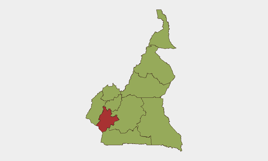
Situation Summary
Cameroon remains a fragmented conflict environment (#29 globally, composite threat 68) characterized by separatist violence in the Anglophone regions (Northwest, Southwest, West) and persistent Boko Haram activity in the Far North. Open-source reporting for the 24–48-hour window (July 21–23, 2026) shows no clearly timestamped new incidents, though developments from July 14–20 indicate sustained armed activity across multiple regions and ongoing kidnapping for ransom by separatist groups. The security picture reflects endemic low-intensity conflict rather than acute destabilization, but localized hotspots remain volatile and unpredictable.
Key Developments
- No clearly documented security or travel-risk incidents reported in open sources for July 21–23, 2026. Current web research confirms a reporting lull; the latest publicly timestamped events cluster around July 14–20.
- Bali Nyonga, Northwest Region (night of July 19–20, 2026): Gunmen believed to be separatist fighters opened fire in a bar, killing one local businessman and injuring two others; attackers also set fire to a public building before departing. This reflects ongoing Anglophone militant activity in Mezam Division.
- Mile 16 Bolifamba, Southwest Region (July 16, 2026): Suspected Ambazonia separatist fighters overran a security checkpoint on the Mutengene–Buea highway, reportedly killing at least one soldier; gunfire disrupted traffic and security forces temporarily abandoned the checkpoint before re-establishing it.
- Bafoussam–Bamenda road, Northwest–West border (late July 18, reported July 19, 2026): Armed men linked to Anglophone separatist groups intercepted a vehicle and kidnapped seven passengers; family reports indicate ransom demands issued for their release, consistent with separatist fundraising tactics.
- Dabanga village, Waza district, Far North Region (mid-July 2026): Suspected Boko Haram fighters raided the village along National Highway 1, killing seven civilians and injuring others, demonstrating sustained Boko Haram presence and capability in the northeast.
- Mokolo subdivision, Far North Region (night of July 14–15, 2026): Boko Haram fighters attacked a Cameroonian army advanced post, killing one civilian and wounding a 15-month-old child; at least four soldiers were injured before troops repelled the assault.
Highest-Risk Areas
Littoral Region carries significantly elevated risk (77.2) and warrants priority focus; Northwest, Southwest, and West regions remain at moderate-to-high risk (47.2 each) due to persistent Anglophone separatist activity, kidnapping operations, and armed clashes with state security forces. Far North and Adamawa (47.2 each) face endemic Boko Haram threat activity. The sub-national gradient reflects separatist militancy concentrated in the Anglophone belt and Boko Haram operations in the Sahel frontier, with Littoral's outlier score likely driven by urban concentration, economic importance, and spillover risk from adjacent conflict zones.
How GeoBit Would Assist
Security teams should deploy AOI Monitoring & Early Warning on known separatist and Boko Haram hotspots (Bali Nyonga, Mile 16 Bolifamba, Mokolo, Waza corridor) to detect real-time activity shifts and armed movement. Conflict & Military battle mapping, force structure, and actor network analysis enable tracking of separatist group organization, command lines, and tactical patterns across the Anglophone regions. Routing & Network Analysis supports identification of safer alternative transportation corridors (e.g., avoiding the Bafoussam–Bamenda road) and predictive assessment of checkpoint vulnerability.
7-Day Outlook
No imminent escalation is signaled by available reporting, but the absence of incidents in the 24–48-hour window does not indicate de-escalation—rather, a reporting gap in a persistently volatile environment. Expect continued low-frequency armed clashes, kidnapping for ransom, and localized security force operations across Anglophone and Far North regions over the next week; developments should be monitored via Intel Sweep, X/Twitter OSINT, and multi-language search to detect any shifts in separatist or Boko Haram operational tempo.
Highest-Risk Areas — Ranked
| # | State / Region | Risk |
|---|---|---|
| 1 | Littoral | 77.2 |
| 2 | Northwest | 47.2 |
| 3 | Southwest | 47.2 |
| 4 | West | 47.2 |
| 5 | Adamawa | 47.2 |
| 6 | Centre | 47.2 |
| 7 | South | 47.2 |
| 8 | Far-North | 47.2 |
| 9 | North | 47.2 |
| 10 | East | 47.2 |
Sources
Previous Daily Briefs
A new Cameroon brief is written every day — each with its own risk map and downloadable CSV. Here's the last week; use the calendar to go further back.
📅 Browse every day by calendar →
Highlighted days have a brief. Tap a day for that day's map & analysis, or “csv” for that day's dataset ($5).
Atlas — our AI intelligence desk — emails them this snapshot personally. Nothing else, no list.