Situation Summary
Chad remains at global threat rank #18 with a composite score of 93, reflecting persistent fragmentation across security, governance, and cross-border dimensions. The security environment is characterised by heightened civil-governance tensions (particularly around law-enforcement and anti-corruption actions), confirmed military posturing along Niger and Cameroon borders, and an ongoing state of emergency in Lac Province following a May terrorist attack. The U.S. State Department maintains a Level 4 "Do Not Travel" advisory, and the country's risk trajectory remains volatile with no near-term de-escalation signals in open reporting.
Key Developments
- Nationwide – 15 July 2026 – Multiple civil-disapproval signals emerged linked to prosecutorial statements against former officials and government entities, indicating rising governance friction and potential controversy around law-enforcement or anti-corruption actions.[1]
- Nationwide – 15 July 2026 – U.S. State Department reconfirmed Chad at alert level 4 ("Do Not Travel"), citing particularly high security risks for foreign nationals including terrorism, kidnapping, and violent crime.[5]
- Nationwide – 14 July 2026 – National-level arrest or detention incident recorded; identity of detainee, charges, and precise location remain unconfirmed in open reporting, flagged as part of a pattern of heightened internal security actions.[1]
- Niger–Chad and Cameroon–Chad border zones – 14 July 2026 – Conventional military forces were exchanged or postured along western and southwestern border areas; cross-border engagement independently corroborated by Cameroon security reporting. Exact positions and force dispositions still require verification.[1][9]
- Lac Province – ongoing through mid-July 2026 – State of emergency remains in effect following a terrorist attack on a military facility on 7 May 2026; continued emergency status and associated security operations significantly raise travel risk and civil-liberty constraints in the province.[4]
- N'Djamena and nationwide – mid-July 2026 – German foreign ministry advisory (updated mid-July) reports very high crime rates nationwide, increased evening police checks in the capital targeting illegal weapons, and persistent risk of violent crime. Political demonstrations and local conflicts noted as capable of occurring without advance warning.[4][7]
Highest-Risk Areas
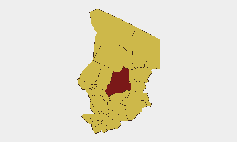
Batha dominates the sub-national risk ranking with a score of 65.2 to 95.2, driven by documented security activity and fragmented governance. Nine additional regions—Ennedi-Ouest, Wadi Fira, Ouaddaï, Sila, Salamat, East Ennedi, Kanem, Lac, and N'Djamena—cluster at 65.2, reflecting distributed rather than concentrated risk. Lac's elevated concern stems from active state-of-emergency measures; border regions (Ennedi-Ouest, East Ennedi, Kanem) reflect cross-border military tension and terrorist-group presence; and the capital faces elevated violent-crime risk and police enforcement intensity. This distribution suggests that risk is neither geographically isolated nor rapidly centralising, but rather endemic across most of the country.
How GeoBit Would Assist
Security teams should deploy AOI Monitoring & Early Warning on Batha, border crossings (Niger, Cameroon), and Lac Province to detect secondary military activity, checkpoint changes, or curfew adjustments. Intel Sweep and multi-language OSINT fusion on governance developments (prosecutorial actions, political statements) would clarify whether current civil-disapproval signals presage larger protests or regime instability. Routing & Network Analysis capabilities enable alternative journey planning around military-concentration areas and real-time checkpoint intelligence to mitigate travel risk for personnel or supply convoys.
7-Day Outlook
No major escalation or de-escalation is apparent in the next 7 days; governance tensions and border posturing are likely to persist at current levels unless a discrete triggering event (arrest of a high-profile figure, border incident escalation, or terrorist attack) forces rapid reassessment. Travel advisories are unlikely to be downgraded in this window. Security teams should treat the current posture as baseline and maintain heightened alertness on Lac, border zones, and N'Djamena.
Highest-Risk Areas — Ranked
| # | State / Region | Risk |
|---|---|---|
| 1 | Batha | 95.2 |
| 2 | Ennedi-Ouest | 65.2 |
| 3 | Wadi Fira | 65.2 |
| 4 | Ouaddaï | 65.2 |
| 5 | Sila | 65.2 |
| 6 | Salamat | 65.2 |
| 7 | East Ennedi | 65.2 |
| 8 | Kanem | 65.2 |
| 9 | Lac | 65.2 |
| 10 | N'Djamena | 65.2 |
| 11 | Hadjer-Lamis | 65.2 |
| 12 | Chari-Baguirmi | 65.2 |
Sources
Previous Daily Briefs
A new Chad brief is written every day — each with its own risk map and downloadable CSV. Here's the last week; use the calendar to go further back.
📅 Browse every day by calendar →
Highlighted days have a brief. Tap a day for that day's map & analysis, or “csv” for that day's dataset ($5).
Atlas — our AI intelligence desk — emails them this snapshot personally. Nothing else, no list.