Situation Summary
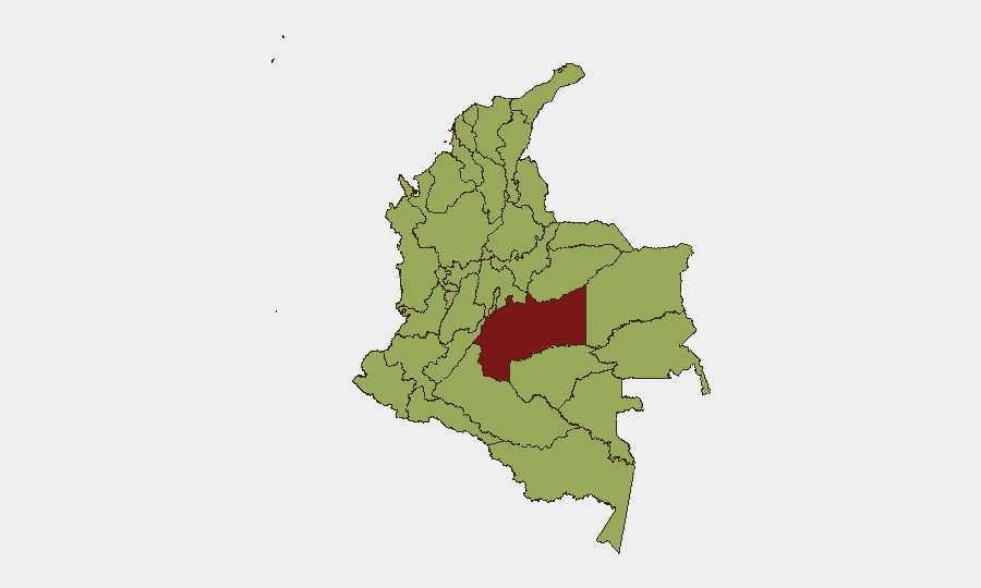
Colombia remains the 24th-highest-threat country globally, with an estimated 276 tracked security events driven primarily by insurgent activity. The security environment is characterized by sustained drone and small-arms attacks in border regions, overlapping criminal-insurgent competition, and sporadic civil unrest. Risk concentration is acute in frontier and southwestern departments, particularly Meta, Nariño, and Cauca, where non-state armed groups maintain operational freedom and access to advanced weaponry.
Key Developments
- Tibú, Norte de Santander – 9 July 2026
A drone-delivered explosive attack on Tibú airport near the Venezuelan border wounded three security staff and damaged administrative facilities. Military and civil aviation sources attribute the strike to the ELN (National Liberation Army), consistent with a documented escalation in armed-drone employment across the border region.
- Small-arms combat incidents – 14 July 2026
Multiple discrete combat signals logged in the event stream, including engagement involving migrant actors. Specific locations and casualty counts remain unclear from open sources; GeoBit platform monitoring is ongoing.
- Police detention of entrepreneur – 14 July 2026
Law enforcement action against a private-sector actor; details limited. Requires clarification as to whether linked to security investigation, financial crime, or labor dispute.
- Institutional friction – 14 July 2026
Public investigation initiated between the Inspector General and Attorney General offices. Nature of dispute not yet specified in open reporting; implications for rule-of-law confidence and executive cohesion warrant monitoring.
- Civilian demonstration – 14 July 2026
Residents staged protest action against government authority, likely linked to service delivery, security, or economic grievance. Scale and specific location require confirmation.
- Presidential and legislative statements – 14 July 2026
Public commentary from the President and a Senator; content and tone not yet detailed in available feeds. Suggests active political response to near-term security or policy trigger.
- Territorial occupation – 14 July 2026
Ministry-level action to occupy or assert control over a location; specifics pending clarification.
- Assassination – 14 July 2026
Single lethal targeting event recorded; parties and location require further corroboration.
Highest-Risk Areas
Meta Department (82.7) dominates the risk profile, driven by ELN and dissident FARC factions competing for coca production and territory in the Llanos region. Nariño, Cauca, and Sucre form a secondary corridor of high threat, rooted in drug-trafficking networks, indigenous/Afro-Colombian land disputes, and armed-group presence near Pacific and Venezuelan borders. Capital District and Cundinamarca (both 54.x) reflect urban crime and occasional spillover from national-level political tensions, though lower than frontier zones. Norte de Santander's ranking (56.1) is now reinforced by the Tibú airport attack, signaling renewed drone-attack capability in the Venezuela-Colombia corridor.
How GeoBit Would Assist
Security teams should deploy AOI Monitoring & Early Warning on Meta, Nariño, Cauca, and Norte de Santander departments to catch emerging drone, small-arms, or territorial-control incidents in near-real time. Network & Actor Analysis would map ELN command, migrant-smuggling networks, and police-private sector friction to clarify motive and cascade risk. Conflict & Military battle-mapping and GIS & Spatial Analysis enable routing of personnel and asset movements away from active combat and territorial-control zones, particularly ahead of cross-border operations.
7-Day Outlook
Drone and small-arms activity in Norte de Santander and Meta is likely to sustain or escalate in response to military counter-insurgency operations. Civilian unrest may persist if grievances cited in today's protests remain unaddressed. Inter-institutional friction between the Attorney General and Inspector General carries political risk; outcomes could affect law-enforcement posture toward armed groups and criminal networks.
Highest-Risk Areas — Ranked
| # | State / Region | Risk |
|---|---|---|
| 1 | Meta Department | 82.7 |
| 2 | Nariño | 59.9 |
| 3 | Cauca | 58.9 |
| 4 | Sucre Department | 57.2 |
| 5 | Norte de Santander Department | 56.1 |
| 6 | Valle del Cauca Department | 54.9 |
| 7 | Atlántico Department | 54.6 |
| 8 | Bolívar Department | 54.2 |
| 9 | Capital District | 54.2 |
| 10 | Cundinamarca Department | 54 |
| 11 | Tolima Department | 53.1 |
| 12 | La Guajira | 53 |
Sources
Previous Daily Briefs
A new Colombia brief is written every day — each with its own risk map and downloadable CSV. Here's the last week; use the calendar to go further back.
📅 Browse every day by calendar →
Highlighted days have a brief. Tap a day for that day's map & analysis, or “csv” for that day's dataset ($5).
Atlas — our AI intelligence desk — emails them this snapshot personally. Nothing else, no list.