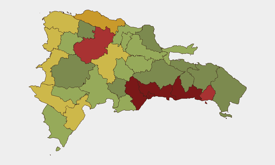
Situation Summary
Dominican Republic remains a moderate-risk environment (global rank #120, composite score 10) with acute localized violence concentrated in urban centers. The past 72 hours have recorded five distinct violent incidents—including the killing of an Air Force major, deaths in criminal confrontations, and community-led expulsions of Haitian migrants following a stabbing death—indicating sustained interpersonal and gang-related violence rather than organized political instability. Santo Domingo and the Nacional District are the primary pressure points, though cross-border migration tensions and sporadic armed clashes are widening the affected geography.
Key Developments
- 2026-08-10, Santo Domingo Este (Nuevo Amanecer del Hipódromo): Air Force Major shot and killed near a local colmado; the officer's son was also wounded. One suspect voluntarily surrendered to authorities.
- 2026-08-09, location unspecified: Two persons killed and two others wounded in an early-morning incident; circumstances under investigation.
- 2026-08-09, agricultural area (Hato Mayor or San Pedro de Macorís region): Body of agricultural worker José Castillo Bello discovered with multiple stab wounds on his finca. Community residents subsequently expelled Haitian nationals and burned properties in retaliation.
- 2026-08-10, Santo Domingo: Police patrols came under attack during a preventive operation; unknown individuals hurled stones and bottles at officers. One police corporal sustained facial injury.
- 2026-08-10, Haina port (Haina Oriental cargo area): DNCD seized a shipment hidden in used-clothing containers containing electronic cigarettes allegedly laced with marijuana.
- 2026-08-06, Santiago: Police Preventive operations yielded firearms, four illegal slot machines, and ten bladed weapons across multiple sectors.
- 2026-08-06, Ciudad Nueva, Santo Domingo: Security was reinforced at the Segundo Tribunal Colegiado following an alleged attempt by DICRIM officers to forcibly remove a witness without judicial authorization during trial proceedings.
Highest-Risk Areas
Santo Domingo (score 92) and the Nacional District (88) are driving the majority of recorded incidents and remain the primary concern for corporate operations. San Cristóbal, San Pedro de Macorís, and La Romana form a secondary cluster (scores 83–78) marked by gang activity and criminal violence. The recent spike in Haitian migrant-related incidents—expulsions, confrontations with police, and retaliatory civilian violence—suggests that border provinces (Dajabón, Elías Piña, Independencia) and transit zones may experience renewed tension, though current reporting remains concentrated in the capital region and its satellites.
How GeoBit Would Assist
Corporate security teams should deploy Intel Sweep and event-feed monitoring to establish continuous watch on Santo Domingo, Nacional District, and secondary risk zones. OSINT fusion and sentiment analysis across local news, X, and Telegram will provide 24–48-hour early warning of community mobilization (as occurred after the Castillo Bello killing). AOI Monitoring & Early Warning configured for high-risk provinces and key facility locations will flag emerging violence hotspots and road-safety hazards; Routing & Network Analysis can identify alternative transit corridors to avoid reported incident zones.
7-Day Outlook
Violent crime is expected to remain episodic and localized unless a major triggering event—such as a high-profile arrest, death in custody, or renewed migrant influx—catalyzes wider unrest. Police operations and preventive patrols will likely continue at current intensity in urban centers. Santo Domingo and satellite municipalities should be treated as ongoing restricted-movement zones for non-essential personnel.
Highest-Risk Areas — Ranked
| # | State / Region | Risk |
|---|---|---|
| 1 | Santo Domingo | 92 |
| 2 | Nacional District | 88 |
| 3 | San Cristóbal | 85 |
| 4 | San Pedro de Macorís | 83 |
| 5 | La Romana | 78 |
| 6 | Santiago | 76 |
| 7 | Puerto Plata | 72 |
| 8 | Elías Piña | 70 |
| 9 | Dajabón | 68 |
| 10 | Barahona | 65 |
| 11 | Independencia Province | 64 |
| 12 | La Vega | 62 |
Sources
Previous Daily Briefs
A new Dominican Republic brief is written every day — each with its own risk map and downloadable CSV. Here's the last week; use the calendar to go further back.
📅 Browse every day by calendar →
Highlighted days have a brief. Tap a day for that day's map & analysis, or “csv” for that day's dataset ($5).
Atlas — our AI intelligence desk — emails them this snapshot personally. Nothing else, no list.