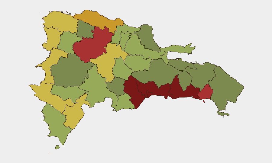
Situation Summary
Dominican Republic remains at moderate composite threat level (rank #122 globally, score 10/100) with a pattern of localized violent incidents and community tensions concentrated in the northern and southwestern provinces. Over the past week, multiple homicides—including the killing of an Air Force Major and an agricultural worker—have occurred amid underlying friction between local communities and Haitian migrant populations. Current trajectory shows episodic rather than sustained violence, though recent incidents involving police conduct and community expulsions indicate fragility in affected municipalities.
Key Developments
- Villa Bisonó (Navarrete), Santiago—2026-08-12: During a 48-hour strike, multiple detonations or discharges were reported near the police director's convoy supervising security operations; police subsequently denied the incidents constituted direct fire on the convoy. National Police and military deployed large security contingents to maintain order and free transit.
- San Víctor, Espaillat—2026-08-12–13: An agricultural worker was discovered with multiple stab wounds, triggering community tension; residents expelled Haitian nationals and burned their belongings. Authorities increased police surveillance in response to prevent further disorder.
- Nationwide—2026-08-06 to -08-10: Multiple homicides recorded, including the fatal shooting of an Air Force Major outside a colmado (with his son also wounded; one suspect voluntarily surrendered) and a man killed by gunfire on Calle Principal in La Cuaba sector.
- Multiple Provinces—2026-08-08: DICRIM and Preventive Police arrested five individuals across separate operations, seizing homemade weapons, controlled substances, and cash. Two arrested were Haitian nationals.
- Nationwide—2026-08-06: Alleged DICRIM members attempted to forcibly remove a key witness during an attempted homicide trial without judicial authorization, raising concerns about law-enforcement accountability.
Highest-Risk Areas
Santo Domingo (risk 92), Nacional District (88), and San Cristóbal (85) dominate the sub-national ranking, reflecting the capital region's concentration of gang activity, property crime, and organized-crime networks. Northern provinces—Santiago (76) and Puerto Plata (72)—show elevated risk tied to drug trafficking and border dynamics with Haiti. Recent incidents in Espaillat and Santiago underscore that secondary cities and rural areas are increasingly sites of communal violence, often intersecting with migration tensions and weak local law-enforcement oversight.
How GeoBit Would Assist
Security teams with personnel or assets in Dominican Republic should employ AOI Monitoring & Early Warning on high-risk municipalities (particularly Santo Domingo, Santiago, and Espaillat) to detect emerging violence clusters and community unrest before escalation. Intel Sweep and multi-language OSINT (including social media and local news sources) provide real-time signal of police conduct, gang activity, and anti-migrant sentiment that inform duty-of-care decisions. Routing & Network Analysis enables alternative journey planning for staff in affected provinces, reducing exposure to hotspot corridors.
7-Day Outlook
Violence patterns are likely to remain episodic and geographically dispersed rather than coalesce into organized campaigns. However, the recent uptick in incidents involving Haitian nationals and community retaliation—combined with apparent law-enforcement friction—suggests that secondary cities in the north and southwest warrant close watch for further communal clashes or vigilante responses over the next week.
Highest-Risk Areas — Ranked
| # | State / Region | Risk |
|---|---|---|
| 1 | Santo Domingo | 92 |
| 2 | Nacional District | 88 |
| 3 | San Cristóbal | 85 |
| 4 | San Pedro de Macorís | 83 |
| 5 | La Romana | 78 |
| 6 | Santiago | 76 |
| 7 | Puerto Plata | 72 |
| 8 | Elías Piña | 70 |
| 9 | Dajabón | 68 |
| 10 | Barahona | 65 |
| 11 | Independencia Province | 64 |
| 12 | La Vega | 62 |
Sources
Previous Daily Briefs
A new Dominican Republic brief is written every day — each with its own risk map and downloadable CSV. Here's the last week; use the calendar to go further back.
- August 12, 2026
- August 11, 2026
- August 10, 2026
- August 9, 2026
- August 8, 2026
- August 7, 2026
- August 6, 2026
📅 Browse every day by calendar →
Highlighted days have a brief. Tap a day for that day's map & analysis, or “csv” for that day's dataset ($5).
Atlas — our AI intelligence desk — emails them this snapshot personally. Nothing else, no list.