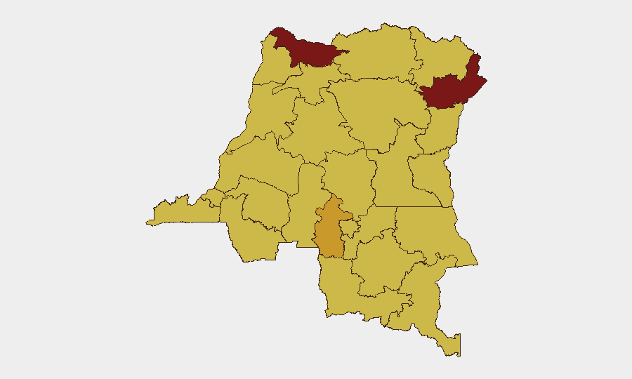
Situation Summary
DR Congo remains at elevated composite threat level (#11 globally, score 99), driven primarily by active insurgency and armed-group activity across multiple provinces. The past 48 hours show a pattern of localized but sustained security incidents spanning armed clashes in North Kivu, armed robbery, intercommunal violence, protest activity in urban centers, and mining-site intrusions—indicating both persistent conflict-zone volatility and emerging pressures in economically sensitive areas. Overall trajectory remains fluid rather than rapidly deteriorating, though incidents in high-traffic commercial zones (Kasindi–Beni road, Goma perimeter) carry direct supply-chain and personnel movement implications.
Key Developments
- Goma, North Kivu (1 July): Overnight fire exchanges between FARDC and suspected M23 elements on northern outskirts near Munigi and Kibati; sporadic small-arms and mortar fire reported; RN2 axis experienced temporary road closures and no confirmed casualty figures yet released.
- Rutshuru territory, North Kivu (1 July): M23 movements intensifying toward Bunagana–Busanza area near Uganda border; commandeered vehicles and temporary checkpoints disrupting commercial traffic across the crossing.
- Beni city, North Kivu (night of 30 June–1 July): Heavy police operations including house-to-house searches following recent ADF-linked attacks; suspect arrests reported and temporary curfews in affected neighborhoods.
- Kasindi–Beni road, North Kivu (30 June): Armed robbery of commercial truck convoy; multiple drivers injured, cargo looted; night-time movement suspension implemented pending additional security escorts.
- Bukavu, South Kivu (1 July): Anti-insecurity and cost-of-living demonstrations near Place de l'Indépendance; police deployed tear gas; several brief arrests reported.
- Kalemie, Tanganyika (30 June): Intercommunal youth clashes over land access north of town; dozens temporarily displaced; local security forces deployed to stabilize.
- Kinshasa (1 July): Heavy police presence around government buildings ahead of opposition-led protests over governance and economic conditions; smaller gatherings dispersed with brief detentions, no major violence.
- Lubumbashi, Haut-Katanga (30 June): Armed intrusion attempt near mining concession; site security and police repelled attackers; operations briefly halted and access routes reinforced.
Highest-Risk Areas
Nord-Ubangi (99.4) and Ituri (86) remain the highest-risk provinces, reflecting sustained armed-group presence and intercommunal conflict. North Kivu and South Kivu, while not topping the sub-national ranking, are generating the densest concentration of active incidents—armed clashes, armed robbery, and police operations—making them operationally critical zones for personnel and asset management. Kinshasa's ranking (70.5) reflects emerging urban-protest dynamics and governance pressures. Mining-dependent zones (Haut-Katanga, Kasai) face both security and economic disruption risk, as demonstrated by the Lubumbashi intrusion attempt and ongoing Kasai volatility.
How GeoBit Would Assist
Security teams operating in DR Congo should deploy AOI Monitoring & Early Warning on Goma, Bukavu, Beni, Kasindi–Beni corridor, and mining concessions to capture incident onset before they impact staff or supply routes. Routing & Network Analysis capability enables real-time alternative-journey planning around active conflict zones, armed-robbery hotspots, and protest sites. Conflict & Military battle mapping and Network & Actor Analysis (M23, ADF disposition and movement) provide contextual understanding of armed-group locations and likely next flashpoints.
7-Day Outlook
Expect continued low-to-moderate intensity clashes in North Kivu's M23-affected zones and sporadic ADF-linked police sweeps in Beni area through early July. Urban protest activity in Kinshasa and Bukavu is likely to recur sporadically around governance and economic grievances. Commercial transport corridors (Kasindi–Beni, border crossings) remain vulnerable to armed robbery and M23 checkpoints; convoy-dependent supply chains should anticipate periodic disruption or routing delays.
Highest-Risk Areas — Ranked
| # | State / Region | Risk |
|---|---|---|
| 1 | Nord-Ubangi | 99.4 |
| 2 | Ituri | 86 |
| 3 | Central Kasai | 72.7 |
| 4 | Kinshasa | 70.5 |
| 5 | Maniema | 69.4 |
| 6 | Sud-Ubangi | 69.4 |
| 7 | Équateur | 69.4 |
| 8 | Mongala | 69.4 |
| 9 | Lower Uele | 69.4 |
| 10 | Tshopo | 69.4 |
| 11 | Tshuapa | 69.4 |
| 12 | Upper Uele | 69.4 |
Sources
Previous Daily Briefs
A new DR Congo brief is written every day — each with its own risk map and downloadable CSV. Here's the last week; use the calendar to go further back.
📅 Browse every day by calendar →
Highlighted days have a brief. Tap a day for that day's map & analysis, or “csv” for that day's dataset ($5).