Situation Summary
Ecuador remains the 35th-highest-threat country globally (composite score 68), driven primarily by insurgency and criminal-organization activity across 36 tracked events. Government and prosecutorial statements on 10–11 July suggest active investigation and enforcement operations, but open-source reporting does not confirm specific new security incidents in the past 24–48 hours. The security posture remains volatile in frontier and coastal provinces, with persistent gang-related homicide, prison instability, and territorial disputes creating an unpredictable operating environment for corporate and expatriate populations.
Key Developments
- Government action (10–11 July). Official statements and investigative activity by prosecutors and authorities indicate ongoing law-enforcement operations; specific incident locations and casualty figures are not yet publicly detailed in independently verified sources.
- International coordination signals (11 July). Foreign ministry and ministerial statements suggest diplomatic or bilateral communication, possibly relating to security cooperation or cross-border actor activity; no specific incident location confirmed.
- Arrest and detention activity (11 July). Police-related detention events flagged; specific charges, localities, and accused identities require confirmation through official Interior Ministry or police channels.
- Presidential action (11 July). Territory-occupation statement attributed to presidential authority; context and location unclear from open sources and require further verification.
- Ongoing investigative posture. Multiple government-led investigations opened between 10–11 July suggest reactive response to an incident or series of incidents; specific details unavailable in current open-source window.
Note: Open-source search results do not surface independently time-stamped incident reports (shooting, bombing, roadblock, prison disturbance, or infrastructure disruption) with a specific location and date in the past 48 hours. Teams requiring real-time incident details should consult dedicated travel-risk platforms, Ecuador's Interior Ministry and National Police social channels, embassy travel advisories, and local Ecuadorian news outlets and verified journalists.
Highest-Risk Areas
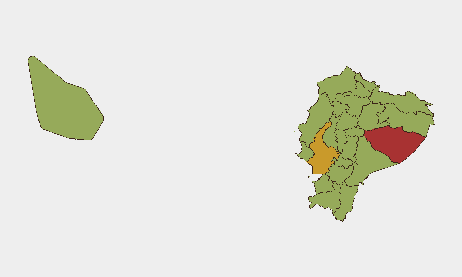
Pastaza Province (77.5) and Guayas Province (71.6) are the primary drivers of national risk. Pastaza, in the eastern Amazon region, is associated with remote border activity, illegal resource extraction, and limited state presence; Guayas, home to Ecuador's largest port (Guayaquil), concentrates urban gang violence, maritime smuggling, and prison instability. Napo, Loja, and Pichincha provinces each carry moderate-to-high risk (48–50), reflecting mixed exposure to insurgent activity, narcotics transit, and urban crime. Northern border regions (Carchi, Sucumbíos, Esmeraldas) and southern Loja remain conduits for cross-border trafficking and armed-group incursion.
How GeoBit Would Assist
Intel Sweep and real-time OSINT (X/Twitter, Telegram, local media feeds, multi-language sentiment analysis) enable continuous monitoring of breaking statements, official announcements, and actor communications to surface and date new incidents hours faster than traditional news cycles. AOI Monitoring and Early Warning deployed on Pastaza, Guayas, Pichincha, and Esmeraldas can trigger alerts on detention, enforcement actions, or territorial markers tied to priority business locations or transit corridors. Network & Actor Analysis and Routing & Network Analysis support journey planning and real-time route avoidance by mapping known gang territory, checkpoints, and recent police operations.
7-Day Outlook
Expect continued government-led enforcement operations and investigative activity in response to the recent incident cluster, likely concentrating in Guayas and Pichincha provinces. Gang-related violence and prison instability will remain chronic; no de-escalation trigger is apparent. Corporate teams should maintain heightened situational awareness, activate real-time intelligence subscriptions, and review contingency protocols for personnel in Guayaquil, Quito, and Amazon-frontier operations.
Highest-Risk Areas — Ranked
| # | State / Region | Risk |
|---|---|---|
| 1 | Pastaza Province | 77.5 |
| 2 | Guayas Province | 71.6 |
| 3 | Napo Province | 50 |
| 4 | Loja Province | 50 |
| 5 | Pichincha Province | 48.3 |
| 6 | Sucumbíos Province | 47.5 |
| 7 | Orellana Province | 47.5 |
| 8 | Manabí Province | 47.5 |
| 9 | Galápagos | 47.5 |
| 10 | Esmeraldas Province | 47.5 |
| 11 | Carchi Province | 47.5 |
| 12 | Imbabura Province | 47.5 |
Sources
Previous Daily Briefs
A new Ecuador brief is written every day — each with its own risk map and downloadable CSV. Here's the last week; use the calendar to go further back.
📅 Browse every day by calendar →
Highlighted days have a brief. Tap a day for that day's map & analysis, or “csv” for that day's dataset ($5).
Atlas — our AI intelligence desk — emails them this snapshot personally. Nothing else, no list.