Situation Summary
Eritrea remains a low-frequency threat environment globally (rank #71, composite score 24), with no discrete security incidents documented in the last 24–48 hours. However, high-tension regional dynamics—particularly escalating military posturing and alleged troop movements along the Eritrea–Ethiopia border in connection with northern Ethiopian conflict zones—create elevated risk in border-adjacent regions and warrant sustained monitoring. Internal conditions including reported fuel shortages and economic constraints persist as underlying stressors, though they have not yet triggered major civil unrest or documented domestic security incidents within the current reporting window.
Key Developments
No discrete, location-specific, independently verified security incidents have been documented inside Eritrea on 16–17 August 2026. The most recent substantive reporting on Eritrean activity dates to 14–15 August 2026 and centers on alleged cross-border military engagement in northern Ethiopia rather than domestic Eritrean incidents. Ongoing signals include:
- Eritrea–Ethiopia border region (14–15 August): Regional media report continued Eritrean military positioning and logistics movement into northern Ethiopian conflict zones (Tigray/Raya–Alamata), though no specific new clash or incident is independently confirmed within the last 48 hours.
- Presidential messaging (14 August): Eritrean President Isaias Afwerki issued warnings against Ethiopian military escalation, reflecting elevated bilateral tensions but not indicative of new domestic incidents.
- Internal economic stress (ongoing, reported mid-August window): Fuel shortages and currency constraints persist; no specific protest, strike, or civil-unrest incident is clearly dated to 16–17 August or substantiated across multiple independent sources.
Note: Claims of internal repression, military activity, or unrest circulating on social media in this period typically lack precise timestamps, multi-source corroboration, or specific locations. Teams should treat unverified social posts as indicators for monitoring, not confirmed incidents, until corroborated by at least two unrelated credible outlets.
Highest-Risk Areas
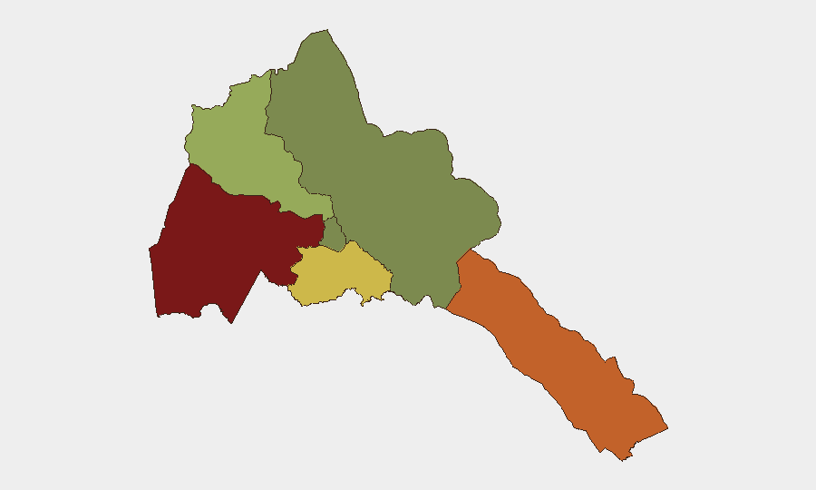
Gash-Barka (risk 92) and Southern Red Sea Region (risk 75) dominate the sub-national ranking, reflecting their proximity to unstable border zones and historical vulnerability to cross-border spillover from Ethiopian conflict. Debub Region (risk 68) carries elevated risk for similar reasons. Maekel Region (risk 18)—which includes the capital, Asmara—remains the lowest-risk zone, though it is not immune to secondary effects of regional escalation or internal economic strain. The pattern reflects geography: border-adjacent regions bear direct exposure to Eritrean military commitments, logistics flows, and potential returnee populations; the central highlands remain more insulated but subject to systemic economic and governance pressures.
How GeoBit Would Assist
Corporate security teams should deploy AOI Monitoring & Early Warning on Gash-Barka and the Southern Red Sea Region to detect cross-border military movements, infrastructure disruptions, or sudden population flows in real time. Intel Sweep and multi-language social/open-source monitoring (X/Twitter, Telegram, regional news feeds) will provide early signals of domestic unrest, supply-chain disruption, or regime-stability shifts. Conflict & Military force-structure tracking and satellite imagery analysis can corroborate allegations of Eritrean military positioning and warn of escalation trajectories affecting border stability and personnel safety.
7-Day Outlook
No imminent domestic security crisis is evident, but the Eritrea–Ethiopia border remains a high-tension interface where clashes, troop repositioning, or cross-border spillover could occur with limited advance warning. Teams should expect continued regional military activity, possible economic tightening in Eritrea, and volatility in border-zone reporting over the next week. Close monitoring of bilateral messaging, Ethiopian conflict updates, and Eritrean internal media is essential for early detection of escalation or sudden policy shifts affecting foreign personnel or assets.
Highest-Risk Areas — Ranked
| # | State / Region | Risk |
|---|---|---|
| 1 | Gash-Barka | 92 |
| 2 | Southern Red Sea Region | 75 |
| 3 | Debub Region | 68 |
| 4 | Anseba | 55 |
| 5 | Maekel Region | 18 |
| 6 | Northen Red Sea Region | 0 |
Sources
Previous Daily Briefs
A new Eritrea brief is written every day — each with its own risk map and downloadable CSV. Here's the last week; use the calendar to go further back.
- August 15, 2026
- August 13, 2026
- August 11, 2026
- August 9, 2026
- August 7, 2026
- August 6, 2026
- August 5, 2026
📅 Browse every day by calendar →
Highlighted days have a brief. Tap a day for that day's map & analysis, or “csv” for that day's dataset ($5).
Atlas — our AI intelligence desk — emails them this snapshot personally. Nothing else, no list.