Situation Summary
Ethiopia remains at the 11th position globally in GeoBit's threat ranking (composite score 86), with civil war as the primary driver. The security environment is characterized by active armed conflict, government crackdowns, and intercommunal violence across multiple regions, with 22 tracked events in the current assessment cycle. No corroborated new security incidents have been confirmed in the last 24–48 hours; the most recent verifiable incidents date to early–mid July 2026. The overall trajectory remains high-risk with structural conflict conditions persisting across the Horn of Africa's most volatile state.
Key Developments
No new incidents confirmed in the last 24–48 hours. GeoBit's live web research and multi-source corroboration protocols indicate that while Ethiopia's threat environment remains acute, no discrete security events meeting the 24–48 hour recency threshold have been independently verified as of 2026-07-25.
Recent baseline context (last 1–2 weeks, for operational awareness):
- Early July, Somali Region: Clan clashes reported near Somali Region boundaries; exact locations and current status require field confirmation.
- Mid-July, Amhara Region (East Gojjam): Artillery shelling incidents reported in prior week; Debre Eyesus area affected by ongoing military operations.
- Ongoing, Afar & Gambela Regions: Persistent armed activity and displacement; humanitarian access severely constrained.
Diplomatic & reputational events (last 24–48 hours): Multiple disapproval statements and public positions exchanged between Ethiopia, the United States, and international prosecutors (2026-07-23 to 2026-07-24); conventional military posturing reported. These do not constitute direct kinetic threats but reflect escalating diplomatic tension and potential for further escalation.
Health signals: Marburg virus disease cases confirmed in Ethiopia (recent, unspecified exact dates); malaria outbreaks concurrent with conflict-driven displacement and disrupted health services.
Highest-Risk Areas
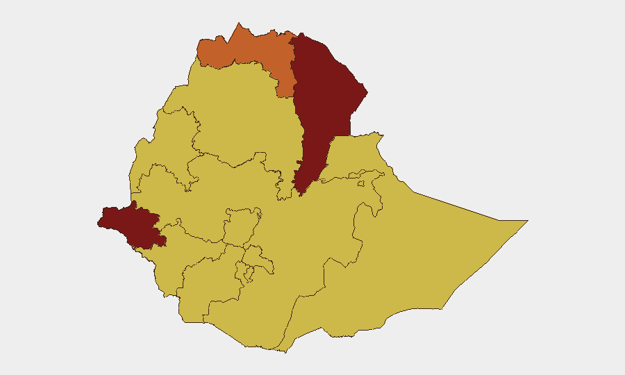
Afar and Gambela Regions jointly drive the highest composite risk scores (90.3 each), followed by Tigray (75.3). These zones feature active armed group presence, limited government control, intercommunal violence, and near-total humanitarian access denial. Amhara, Benishangul-Gumuz, and Somali Regions (all 60.3) remain secondary but substantial risk zones, with ongoing military operations, clan conflict, and government security operations. Addis Ababa itself (60.3) reflects political instability, diplomatic tension, and potential for civil unrest linked to national-level governance crises. Mid-tier regions including Oromia and South Ethiopia show persistent (60.3) risk driven by residual conflict dynamics and government presence.
How GeoBit Would Assist
Corporate security and duty-of-care teams monitoring Ethiopia would leverage AOI Monitoring & Early Warning (persistent, real-time watch on offices, supply routes, and staff locations in high-risk regions); Intel Sweep & OSINT fusion (multi-language social media, Telegram, radio SIGINT tracking of armed group movements and government operations); and Routing & Network Analysis (alternative journey planning and safe-corridor assessment for personnel movement). GIS & Spatial Analysis combined with satellite imagery provides pattern-of-life assessment in Afar, Gambela, and Amhara, while conflict & military tracking monitors force disposition and escalation signals.
7-Day Outlook
Diplomatic escalation between Ethiopia and Western actors (visible in 24–48 hour statements) may signal underlying military tensions. The absence of confirmed new kinetic incidents in the last two days does not indicate de-escalation; rather, structural conflict in Afar, Gambela, and Amhara persists with sporadic, localized violence. Staff safety protocols and asset protection in all tier-1 and tier-2 regions should remain elevated through at least early August pending clearer signal of reduced operational tempo.
Highest-Risk Areas — Ranked
| # | State / Region | Risk |
|---|---|---|
| 1 | Afar Region | 90.3 |
| 2 | Gambela Region | 90.3 |
| 3 | Tigray | 75.3 |
| 4 | Amhara Region | 60.3 |
| 5 | Benishangul-Gumuz Region | 60.3 |
| 6 | Somali Region | 60.3 |
| 7 | South West Ethiopia Peoples | 60.3 |
| 8 | Addis Ababa | 60.3 |
| 9 | South Ethiopia Regional State | 60.3 |
| 10 | Central Ethiopia Regional State | 60.3 |
| 11 | Oromia Region | 60.3 |
| 12 | Sidama | 60.3 |
Sources
Previous Daily Briefs
A new Ethiopia brief is written every day — each with its own risk map and downloadable CSV. Here's the last week; use the calendar to go further back.
📅 Browse every day by calendar →
Highlighted days have a brief. Tap a day for that day's map & analysis, or “csv” for that day's dataset ($5).
Atlas — our AI intelligence desk — emails them this snapshot personally. Nothing else, no list.