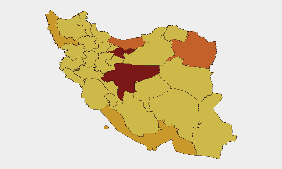
Situation Summary
Iran is currently engaged in active military escalation with U.S. and regional forces, marked by reciprocal drone, missile, and airstrikes across the Gulf theater since June 29–July 2, 2026. While regional conflict intensity is severe, confirmed security incidents *inside Iran proper* remain absent from open reporting in the last 24–48 hours; the primary threat to personnel and assets originates from external military operations, infrastructure disruption (telecommunications, power, aviation), and maritime hazards near the Strait of Hormuz. Iran's composite threat ranking remains #2 globally (score 100), driven by documented military strike activity and 728 tracked events. Trajectory is escalatory; additional U.S. or allied strikes on Iranian military infrastructure are considered likely in the near term.
Key Developments
- Strait of Hormuz (June 30–July 1, 2026): Singapore-flagged commercial vessel struck by Iranian drone in shipping lane; subsequent U.S. retaliatory airstrikes on Iranian military targets confirmed across the Gulf. Elevated maritime hazard and crew risk in international waters proximate to Iranian territorial waters.
- Gulf airspace & IRGC operations (June 30–July 1, 2026): Multi-drone assaults by IRGC on Gulf facilities and reciprocal U.S. Central Command airstrikes on Iranian targets confirmed. Ongoing tit-for-tat operations indicate sustained escalation cycle.
- Bahrain (June 30–July 1, 2026): IRGC drone attacks on multiple locations including areas near U.S. Fifth Fleet facilities; confirmed by Bahrain Foreign Ministry and U.S. officials. Secondary risk to allied personnel and heightened security screening for Iran-linked movements.
- Kuwait—Ali Al Salem Air Base & Al Asad facility (June 30–July 1, 2026): Iranian drone and missile strikes on U.S.-linked military sites in retaliation for recent U.S. strikes on Iranian territory. Corroborated by IRGC statements and regional reporting.
- Iranian military infrastructure (June 30–July 1, 2026): U.S. Navy and Air Force strikes on Iranian surveillance, communications, air-defense, drone storage, and mine-laying capabilities. Intelligence briefs warn of potential telecommunications blackouts and power outages affecting Iranian territory on short notice.
- National travel advisory (July 1, 2026): Government-level guidance reiterates directive to avoid all travel to Iran, citing heightened military-activity risk, flight cancellations, and threatened telecom/power outages.
- Domestic security inside Iran (June 30–July 2, 2026): No confirmed civil unrest, terror attacks, or major crime spikes reported in Iranian cities or provinces during the last 48 hours in open sources, despite acute regional tension.
Highest-Risk Areas
Tehran Province (risk 100) and Isfahan Province (risk 86) remain the highest-exposure zones, followed by Mazandaran, Razavi Khorasan, and West Azerbaijan. However, southern provinces—Hormozgan (71.3), Bushehr (71.1), and Gulf-facing regions—carry acute *infrastructure disruption risk* from external military operations and maritime incidents. Risk elevation is driven by proximity to U.S. strike zones, telecommunications and power infrastructure vulnerability to airstrikes, and air-route concentration. Northern border regions (Kurdistan, East Azerbaijan, North Khorasan, Ilam) maintain elevated baseline risk from cross-border activity and historical instability, but are not currently primary military theaters.
How GeoBit Would Assist
Corporate security teams operating in Iran should deploy AOI Monitoring & Early Warning on Tehran, Isfahan, and Hormozgan to detect renewed military activity or infrastructure disruption on 4–6 hour alert cycles. Routing & Network Analysis can model alternative in-country logistics and personnel movement routes bypassing high-risk southern corridors and telecom-vulnerable zones. Maritime & Aviation tracking, combined with Intel Sweep (X, Telegram, multi-language OSINT) and Conflict & Military (force positioning, strike capability) analysis, enables real-time hazard detection for supply chains and personnel transits.
7-Day Outlook
Escalation is likely to continue through early July, with probability of additional U.S. or allied strikes on Iranian military targets in response to further Iranian drone/missile activity. Telecommunications and power outages may occur with minimal warning. Personnel and asset protection should prioritize redundant communications, alternative routing, and pre-positioned contingency plans for evacuation or shelter-in-place protocols.
Highest-Risk Areas — Ranked
| # | State / Region | Risk |
|---|---|---|
| 1 | Tehran Province | 100 |
| 2 | Isfahan Province | 86 |
| 3 | Mazandaran Province | 75.4 |
| 4 | Razavi Khorasan | 74 |
| 5 | West Azerbaijan Province | 71.7 |
| 6 | Hormozgan Province | 71.3 |
| 7 | Bushehr Province | 71.1 |
| 8 | Kurdistan Province | 70.6 |
| 9 | East Azerbaijan Province | 70.1 |
| 10 | Yazd Province | 70.1 |
| 11 | North Khorasan Province | 70 |
| 12 | Ilam Province | 70 |
Sources
Previous Daily Briefs
A new Iran brief is written every day — each with its own risk map and downloadable CSV. Here's the last week; use the calendar to go further back.
📅 Browse every day by calendar →
Highlighted days have a brief. Tap a day for that day's map & analysis, or “csv” for that day's dataset ($5).