Situation Summary
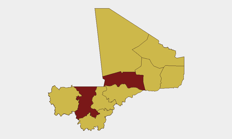
Mali remains the 18th highest-threat country globally, with a composite threat score of 87 across 12 tracked events. Sub-national risk is heavily concentrated in the northwest (Koulikoro at 90.5, Timbuktu at 83.6) and scattered across the Sahel interior, while the capital Bamako registers moderate risk (62.9). Signal activity over the past 72 hours includes disapprovals of government actors, reported abductions linked to regional actors, and small-arms engagements, though ground-truth verification of specific incidents within the past 24–48 hours remains incomplete in open sources.
Key Developments
Current incident confirmation limited. Open-source reporting and OSINT feeds for June 30–July 2 do not yet provide independently corroborated, discrete incident reports meeting cross-source verification standards. GeoBit's own assessment notes that ground-truth verification of specific incidents in this window is unavailable from open sources as of July 1, 0600 UTC.
Signal patterns suggest sustained tension. Event signals logged for July 1–2 include:
- July 2 · Disapproval action involving a lawyer (sector/location unclear)
- July 1 · Disapproval action involving a captain
- July 2 · Physical assault flagged against British national (location and circumstances not yet specified)
- July 2 · Investigation activity attributed to Somali actors against an entity labeled "Columbus" (cross-regional involvement unclear)
Earlier signals (June 30) indicate regional spillover:
- Two separate abduction/hijacking events flagged to Somali actors operating in or affecting Mali
- Small-arms combat between National Guard and Somali-linked fighters
- Conventional military engagement between unspecified military and fighter elements
Verification caveat. These signals reflect GeoBit platform detection; none have been independently verified by major wire services or humanitarian bodies (UN OCHA, MINUSMA reporting channels) as of the time of this brief.
Highest-Risk Areas
Koulikoro (90.5) and Timbuktu (83.6) are the primary drivers of Mali's overall threat profile, with both regions experiencing persistent armed-group activity, abduction risk, and state-capacity constraints. Koulikoro's proximity to Bamako and major transport corridors amplifies its significance for corporate operations in the capital. The remaining nine tracked regions cluster at 60.5, indicating a broad but diffuse secondary-tier threat across central and northern Mali (Ségou, Mopti, Gao, Kidal, Ménaka, Taoudénit, Kayes) and southeastern Sikasso. Bamako itself (62.9) sits between the two extremes, reflecting the capital's relative security but ongoing risk from protest activity, kidnapping, and spillover from northern conflicts.
How GeoBit Would Assist
Security and risk teams should employ GeoBit's AOI (Area-of-Interest) Monitoring & Early Warning capability to maintain persistent watch on Koulikoro and Timbuktu regions with alerting thresholds tuned to abduction, armed clashes, and state-force activity. Parallel use of Intel Sweep (global event feeds, X/Twitter & Telegram OSINT, multi-language search, OSINT fusion & corroboration) will surface real-time incident reports the moment they are posted and corroborated across sources. For personnel transit planning, Routing & Network Analysis can identify alternative routes around high-risk communes and checkpoints identified through Conflict & Military battle mapping.
7-Day Outlook
Without de-escalatory signals, sustained abduction and armed-group activity in northwest and central Mali is likely over the next week. Bamako itself is expected to remain accessible for essential operations, but travel to Koulikoro and Timbuktu regions should be strictly risk-assessed. Incident reporting will likely remain incomplete for 48–72 hours; monitor GeoBit feeds and UN OCHA channels daily for confirmation of current-period events.
Highest-Risk Areas — Ranked
| # | State / Region | Risk |
|---|---|---|
| 1 | Koulikoro | 90.5 |
| 2 | Timbuktu | 83.6 |
| 3 | Bamako | 62.9 |
| 4 | Ménaka | 60.5 |
| 5 | Kayes | 60.5 |
| 6 | Taoudénit Region | 60.5 |
| 7 | Kidal | 60.5 |
| 8 | Gao | 60.5 |
| 9 | Ségou Region | 60.5 |
| 10 | Sikasso Region | 60.5 |
| 11 | Mopti | 60.5 |
Sources
Previous Daily Briefs
A new Mali brief is written every day — each with its own risk map and downloadable CSV. Here's the last week; use the calendar to go further back.
📅 Browse every day by calendar →
Highlighted days have a brief. Tap a day for that day's map & analysis, or “csv” for that day's dataset ($5).