Situation Summary
Myanmar remains in acute civil conflict, with nationwide deaths exceeding 100,000 as of late June 2026. The junta's military operations against armed-resistance forces continue at intensity across central and border regions, compounded by concurrent flooding that disrupts movement and supply chains. Urban centers including Yangon and Mandalay are experiencing heightened security sweeps, arbitrary detention, and night operations. The composite national threat score of 100 reflects sustained conventional military clashes, cross-border spillover risk, and civilian exposure across multiple states.
Key Developments
- Yangon Region (1–2 July 2026): Heightened checkpoints, night-time raids, and arbitrary detentions reported in Hlaing Tharyar and North Dagon townships as junta forces respond to resistance activity. Travel and personal-security risk elevated in urban areas.
- Central Interior — Magway, Sagaing, Mandalay (30 June–early July 2026): Intensive junta airstrikes and artillery shelling continue against resistance positions across the "Anyar" belt. Village access roads remain disrupted; destroyed villages and blocked routes confirmed in rural areas by local monitors over the past 48 hours.
- Myawaddy Township, Kayin State / Thai Border (29–30 June 2026): Cross-border shelling reported near Myawaddy on 29 June, with Myanmar military artillery impacting areas close to Thailand. Thai authorities issued public statements on border-security concern; movement restrictions and spillover risk persist into early July.
- Nationwide Flooding (late June–early July 2026): Concurrent flooding across multiple regions restricts road access and constrains personnel and supply-chain movement, particularly in conflict-affected rural areas. Overland travel and evacuation options remain degraded.
- Kachin State (late June 2026): Sustained armed clashes and ambushes reported; key highway corridors including Bhamo–Myitkyina assessed as unpredictable and high-risk. Composite threat index reflects elevated combat activity and military operations.
- Mandalay Region (late June 2026): Urban and peri-urban security operations, arrests, and sporadic clashes ongoing. Night patrols, raids targeting suspected resistance sympathizers, and short-notice road closures create volatile movement conditions within and around the city.
Highest-Risk Areas
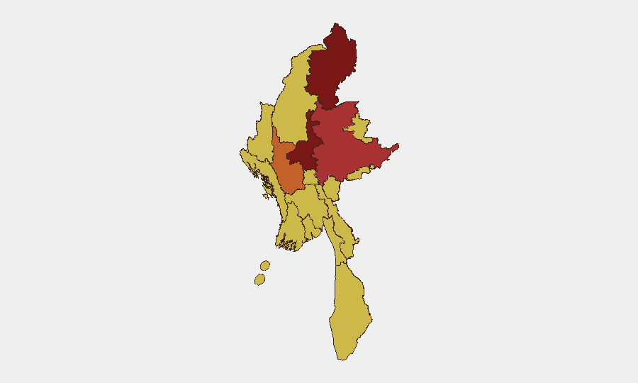
Kachin State (risk 100) and Mandalay (82.7) drive the highest sub-national threat scores, driven by sustained conventional military operations, armed clashes, and active junta security sweeps respectively. The central "Anyar" belt—Magway (75.8) and Sagaing (70.7)—faces intensive airstrikes and artillery disruption affecting civilian corridors. Shan State (77.1) remains high-risk due to ongoing armed activity. The grouping of Rakhine, Ayeyarwady, Naypyitaw, and Yangon at risk 70 reflects a broader baseline of junta operations and resistance activity present nationwide; Yangon's score is anchored in urban security operations and detention activity rather than active combat, but poses material risk to movement and personal security.
How GeoBit Would Assist
Security teams should deploy AOI Monitoring & Early Warning for persistent watch on Kachin, Mandalay, and Sagaing with automated alerting tied to conflict-monitor feeds and OSINT. Routing & Network Analysis capabilities enable alternative journey planning around checkpoints, road closures, and flooding disruption. Conflict & Military (force structure, battle mapping) and Intel Sweep (multi-language OSINT fusion) provide real-time tactical picture and early warning of military operations affecting specific townships and road networks.
7-Day Outlook
Airstrikes and artillery operations are assessed as continuing across central regions through the forecast period. Flooding impact is expected to begin receding but will constrain overland travel through early July. Urban security sweeps in Yangon and Mandalay are likely to remain elevated, with short-notice restrictions and detention risk. Border-area shelling near Myawaddy may persist, sustaining cross-border spillover concern.
Highest-Risk Areas — Ranked
| # | State / Region | Risk |
|---|---|---|
| 1 | Kachin State | 100 |
| 2 | Mandalay | 82.7 |
| 3 | Shan State | 77.1 |
| 4 | Magway | 75.8 |
| 5 | Sagaing Region | 70.7 |
| 6 | Tanintharyi Region | 70 |
| 7 | Chin | 70 |
| 8 | Wa State (Northern Region) | 70 |
| 9 | Rakhine | 70 |
| 10 | Ayeyarwady | 70 |
| 11 | Yangon | 70 |
| 12 | Naypyitaw Union Territory | 70 |
Sources
Previous Daily Briefs
A new Myanmar brief is written every day — each with its own risk map and downloadable CSV. Here's the last week; use the calendar to go further back.
📅 Browse every day by calendar →
Highlighted days have a brief. Tap a day for that day's map & analysis, or “csv” for that day's dataset ($5).