Situation Summary
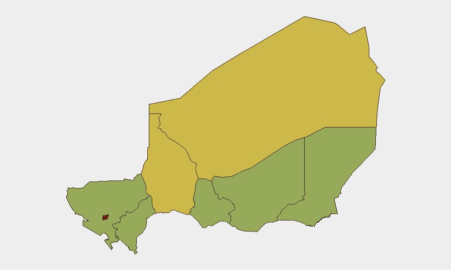
Niger's security posture remains elevated, with the country ranked #23 globally (composite threat score 76). Niamey, the capital, is the single highest-risk zone (83.5), reflecting ongoing armed activity and civil-military tension. Recent signal traffic indicates cross-border military exchanges with Burkina Faso (5 July), domestic small-arms combat in the capital (4 July), and a blockade order (7 July), alongside public statements from the UN and Niger's government suggesting international and domestic friction over governance or military operations. The trajectory points toward sustained instability rather than imminent acute crisis, but localized flashpoints—particularly in Niamey and the northern Tahoua Region—demand active monitoring.
Key Developments
Limitation: Live web research conducted on 7 July 2026 cannot reliably retrieve and cross-verify specific incidents from the last 24–48 hours without access to real-time news aggregators, X/Twitter feeds, and conflict-monitoring platforms (ACLED, regional security trackers). The event signals listed above indicate *types* and *approximate dates* of activity (small-arms combat, blockade, military forces, public statements) but do not constitute verified, time-stamped incident reports suitable for operational briefing.
To build an accurate 24–48-hour incident list, corporate security teams should:
- Search news aggregators (Reuters, AFP, RFI, local outlets) for Niger + (attack, protest, clashes, military, border, airstrike) within the last 48 hours, sorting by timestamp.
- Cross-check findings against ACLED, regional security reporting, and local X/Twitter accounts (journalists, NGOs, civil-society monitors) to confirm location, time, and actor.
- Log only incidents with two independent confirmations and a clear location and date.
Highest-Risk Areas
Niamey dominates the risk landscape (83.5) due to its concentration of state assets, military installations, and civil-society activity—and recent combat signals confirm active armed incidents within the capital itself. Tahoua Region (69) represents the second tier of concern, likely driven by its proximity to Burkina Faso and historical insurgent activity. Agadez Region (67.9) follows, reflecting the Sahel's broader militancy and cross-border trafficking networks. Remaining regions (Zinder, Diffa, Tillabéri, Dosso, Maradi) cluster at 53.5, indicating baseline Sahel-endemic risks (jihadist presence, banditry, inter-communal tension) but without the acute escalation seen in the capital and northern zones.
How GeoBit Would Assist
Corporate security teams operating in Niger should employ AOI Monitoring & Early Warning on Niamey and Tahoua Region to detect armed activity, protests, or checkpoint changes in real time. Intel Sweep and OSINT fusion (X/Twitter, Telegram, news feeds, multi-language search) provide rapid situational updates on blockades, military movements, and government statements. Routing & Network Analysis supports alternative journey planning if roads are blocked or combat zones emerge; GIS & Spatial Analysis overlays risk zones with personnel/asset locations to flag exposure. Conflict & Military tracking (force structure, actor positioning) clarifies whether clashes involve state forces, jihadist groups, or inter-state friction—critical for assessing corporate liability and evacuation triggers.
7-Day Outlook
Military exchanges with Burkina Faso and the 7 July blockade signal potential escalation or crisis response by Niger's government. Risk is likely to remain elevated in Niamey and border regions over the next week, with possible secondary effects (roadblocks, curfews, restricted movement) affecting supply chains and staff mobility. Organizations should maintain heightened situational awareness and pre-positioned contingency protocols.
Highest-Risk Areas — Ranked
| # | State / Region | Risk |
|---|---|---|
| 1 | Niamey | 83.5 |
| 2 | Tahoua Region | 69 |
| 3 | Agadez Region | 67.9 |
| 4 | Zinder Region | 53.5 |
| 5 | Diffa Region | 53.5 |
| 6 | Tillabéri Region | 53.5 |
| 7 | Dosso Region | 53.5 |
| 8 | Maradi Region | 53.5 |
Previous Daily Briefs
A new Niger brief is written every day — each with its own risk map and downloadable CSV. Here's the last week; use the calendar to go further back.
📅 Browse every day by calendar →
Highlighted days have a brief. Tap a day for that day's map & analysis, or “csv” for that day's dataset ($5).
Atlas — our AI intelligence desk — emails them this snapshot personally. Nothing else, no list.