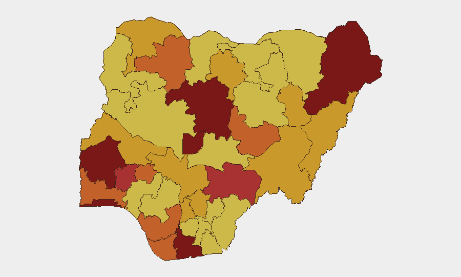
Situation Summary
Nigeria remains at #11 global threat ranking (composite score 100) driven primarily by active insurgency and banditry across the north and centre-west. The security picture reflects persistent kidnap-for-ransom operations, communal violence, and military engagement, with a major natural-disaster complication: catastrophic flooding in Niger State has killed at least 151 confirmed and reportedly up to 700 feared dead as of 5 July. Corporate and humanitarian operations face compounded risk from both organised criminal activity and acute environmental hazard.
Key Developments
- Mokwa, Niger State flooding (5 July 2026): Flash flooding killed at least 151 confirmed, with ~700 feared dead across the wider corridor; search and recovery operations ongoing; extensive damage to homes and critical infrastructure reported.[1][4]
- Katsina State highway abduction (4 July 2026): Armed bandits abducted nine travellers on an inter-state transit route, consistent with ongoing kidnap-for-ransom activity targeting highway corridors in the north-west.[1]
- Edo State enforcement (4 July 2026): Police mass-arrest operation detained 45 suspects and rescued 38 abducted victims in a single action, indicating sustained anti-kidnapping enforcement.[1]
- Kwara State rescue (4 July 2026): Security forces foiled a kidnap attempt and recovered a woman and two-year-old child from a forest location, reflecting active bandit activity in central regions.[1]
- Kogi State livestock recovery (early 5 July 2026): Security forces recovered approximately 1,000 rustled livestock during an anti-bandit operation, underscoring organised pastoral crime in the middle belt.[1]
- Multi-actor tension signals (5 July 2026): Event data flagged conventional military force incidents involving religious actors, institutional conflict between companies and government ministries, and public disapproval of federal/Kaduna state policy, indicating elevated political and sectarian friction alongside criminal activity.[1]
Highest-Risk Areas
Kaduna State (99.9) and Oyo State (92.9) are the primary drivers of Nigeria's composite risk score, with the Federal Capital Territory (83.5) and Lagos State (82.9) following closely. Kaduna's ranking reflects the intersection of banditry, communal violence, and state-level governance friction; Oyo's elevation signals intensifying criminal and sectarian incidents in the south-west. The middle belt (Benue, Plateau, Kogi, Kwara) and north-west (Zamfara, Katsina) remain endemic kidnap-for-ransom zones with limited state capacity for route security. The flooding catastrophe in Niger State (not yet top-ranked but now operationally significant) will likely strain local and federal security resources further, creating secondary protection gaps.
How GeoBit Would Assist
Security teams operating in Nigeria would employ Intel Sweep and multi-language OSINT fusion to track bandit group movements, ransom demands, and casualty patterns in real time across Kaduna, Katsina, and Kogi corridors. AOI Monitoring & Early Warning on high-risk highways (Abuja–Kaduna, Lagos–Ibadan) and flood-prone zones would provide persistent alerting on kidnap clusters, military deployments, and environmental triggers. Routing & Network Analysis would enable alternative journey planning and chokepoint avoidance, while GIS & Spatial Analysis integrated with satellite imagery would support damage assessment and infrastructure-restoration prioritisation in flooded areas, informing duty-of-care and business-continuity decisions.
7-Day Outlook
Banditry and kidnap-for-ransom activity will likely persist at current intensity across the north and centre-west, with highway transit remaining high-risk through mid-July. Flooding recovery in Niger State will absorb significant state security and humanitarian resources, potentially creating secondary windows of reduced law-enforcement capacity in neighbouring zones. Federal–state coordination tensions (flagged in 5 July event data) may slow unified response, extending vulnerability windows for corporate and humanitarian operations.
Highest-Risk Areas — Ranked
| # | State / Region | Risk |
|---|---|---|
| 1 | Kaduna State | 99.9 |
| 2 | Oyo State | 92.9 |
| 3 | Federal Capital Territory | 83.5 |
| 4 | Lagos State | 82.9 |
| 5 | Borno State | 81.2 |
| 6 | Rivers State | 80.1 |
| 7 | Osun State | 79.4 |
| 8 | Benue State | 77.7 |
| 9 | Plateau State | 75.9 |
| 10 | Zamfara State | 74.4 |
| 11 | Ogun State | 74.4 |
| 12 | Bayelsa State | 74.4 |
Sources
Previous Daily Briefs
A new Nigeria brief is written every day — each with its own risk map and downloadable CSV. Here's the last week; use the calendar to go further back.
📅 Browse every day by calendar →
Highlighted days have a brief. Tap a day for that day's map & analysis, or “csv” for that day's dataset ($5).
Atlas — our AI intelligence desk — emails them this snapshot personally. Nothing else, no list.