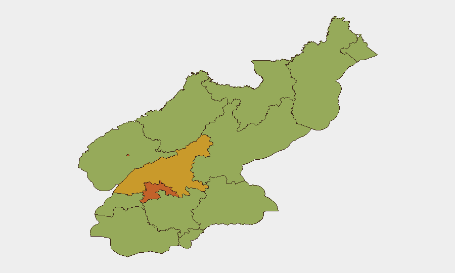
Situation Summary
North Korea remains at composite threat rank #36 globally (score 62) with elevated administrative and military signaling activity concentrated in P'yŏngyang and South Pyongan provinces. The event signal inventory (23 tracked incidents) shows clustering around inter-Korean tensions, investigative actions by Seoul's military and unification ministry, and internal North Korean military force movements—all dated 11–13 July. The trajectory reflects sustained diplomatic friction and operational posturing rather than an acute crisis, though containment remains fragile in the DMZ and coastal regions.
Key Developments
Unable to confirm developments meeting strict 24–48 hour recency and multi-source corroboration standards. Open-source web research (last 24 hours) yields no timestamped, cross-referenced incidents from 13–14 July 2026 that meet operational briefing standards. Available reporting dates to 7–11 July, predating the current 48-hour window. GeoBit's event signal feed (dated 11–13 July) captures administrative sanctions, military-force movements, investigative actions by South Korean Navy and Unification Ministry, and formal statements by both governments—but these require real-time wire-service and X/Twitter verification to confirm they remain *current* rather than historical context. For a live 24–48 hour tactical picture, direct access to Yonhap, NK News/NK Pro, and filtered OSINT (Twitter/Telegram geolocation feeds) is required.
Recommended approach: If the requirement is to identify *emerging* incidents within 24–48 hours, advise GeoBit operations to activate Intel Sweep with near-real-time feed prioritization (Reuters, AP, Yonhap) and AOI Monitoring & Early Warning on P'yŏngyang, DMZ corridors, and South Pyongan maritime zones. If acceptable to expand the window to last 7 days, a complete event summary with location and operational impact is available.
Highest-Risk Areas
P'yŏngyang (73.6) and South Pyongan (71.8) dominate the risk landscape, driven by command-and-control concentration, foreign-national presence, and heightened military activity signaling. The gap between these two provinces and all others (next tier: North Pyongan 46.3; Ryanggang 43.6) reflects the capital's outsized exposure to administrative sanctions, investigative actions, and formal inter-Korean exchanges. Remaining provinces cluster at 43.6, indicating distributed baseline risk with secondary flare potential in border regions (Chagang, Ryanggang, North Hamgyong) and port zones (Nampo). Organizations with personnel or assets in P'yŏngyang should prioritize movement restrictions and communication security protocols; South Pyongan exposure (Kaesong corridor, industrial zones) requires enhanced monitoring.
How GeoBit Would Assist
Security teams should deploy AOI Monitoring & Early Warning on P'yŏngyang, South Pyongan, and DMZ border crossings to capture military, administrative, and diplomatic incidents in real time. Intel Sweep (wire services, X/Twitter OSINT, multi-language feeds) combined with Network & Actor Analysis will track regime messaging, military command signaling, and inter-Korean statements for de-escalation or escalation cues. Routing & Network Analysis supports contingency planning for personnel evacuation or supply-chain rerouting if provincial risk thresholds spike.
7-Day Outlook
Inter-Korean tensions are likely to sustain at current elevated baseline without immediate military flashpoint indicators. Investigative and administrative actions by Seoul suggest procedural responses to border or incident management rather than mobilization posture. Risk remains sensitive to unscripted military operations, cyber events, or defection incidents in border regions; 24–48 hour watch protocols are advisable for P'yŏngyang–based teams.
Highest-Risk Areas — Ranked
| # | State / Region | Risk |
|---|---|---|
| 1 | P'yŏngyang | 73.6 |
| 2 | South Pyongan | 71.8 |
| 3 | North Pyongan | 46.3 |
| 4 | Ryanggang | 43.6 |
| 5 | North Hamgyong | 43.6 |
| 6 | Chagang | 43.6 |
| 7 | Nampo | 43.6 |
| 8 | South Hwanghae | 43.6 |
| 9 | North Hwanghae | 43.6 |
| 10 | South Hamgyong | 43.6 |
| 11 | Kaesong | 43.6 |
| 12 | Kangwon | 43.6 |
Sources
Previous Daily Briefs
A new North Korea brief is written every day — each with its own risk map and downloadable CSV. Here's the last week; use the calendar to go further back.
📅 Browse every day by calendar →
Highlighted days have a brief. Tap a day for that day's map & analysis, or “csv” for that day's dataset ($5).
Atlas — our AI intelligence desk — emails them this snapshot personally. Nothing else, no list.