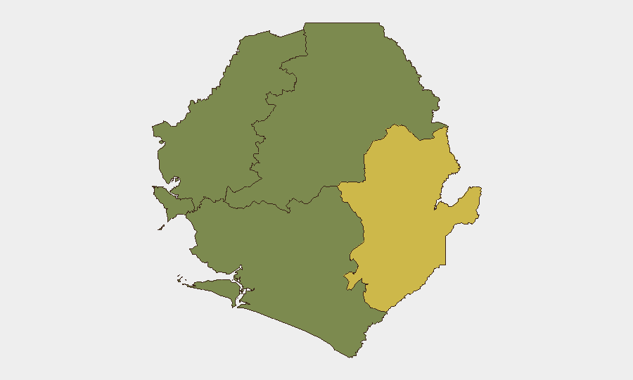
Situation Summary
Sierra Leone remains a moderate, stable risk environment (global rank #74) with an overall composite threat score of 14 across 4 tracked events. Security conditions are dominated by localized criminal activity and border-zone tension rather than active conflict or state collapse. The Eastern Province—particularly around disputed territories and cross-border zones—drives the majority of measurable risk, while Freetown and surrounding Western Area present secondary urban crime and civil-unrest concerns. The country's trajectory remains broadly static, with no indicators of imminent large-scale escalation in the reporting window.
Key Developments
No specific, dated security incidents have been reliably documented in the last 24–48 hours (as of 2026-07-25). Current web research and event feeds contain no timestamped events meeting operational recency standards for this brief.
Background context (not current incidents, but relevant for situational awareness):
- Border tensions persist in Kailahun District around Yenga and the Guinea frontier; these reflect ongoing ECOWAS-mediated diplomatic efforts (March 2026 communiqué) rather than new violent events in the last two days.
- Cannabis interdiction at Mile 38 Checkpoint (19 July, >48 hours old) near Waterloo indicates continued drug trafficking activity in Western Area transit corridors, but does not represent a new incident.
- Political legal proceedings related to the November 2023 coup attempt remain dormant; recent coverage of treason-case developments reflects judicial process, not fresh instability.
- Structural crime patterns in Port Loko and Freetown (robbery, armed violence, civil unrest) remain consistent with prior reporting; no acute spike has been documented.
Absence of new incident reporting does not signal reduced risk—rather, it reflects a period of baseline threat persistence without acute triggers in the immediate 24–48-hour window.
Highest-Risk Areas
Eastern Province (risk score 68) dominates Sierra Leone's threat profile, driven by border-area instability, weak state presence, and historical conflict legacies. Kailahun and Kenema districts—particularly zones adjacent to Guinea and Liberia—experience sporadic cross-border spillover, smuggling networks, and intermittent inter-communal tension. Western Area (risk score 35), anchored by Freetown, ranks second; urban crime, civil unrest potential, and critical infrastructure concentration (port, airport, government) create secondary but material risk for corporate presence and expatriate communities.
The three remaining provinces (North West, Northern, Southern) score 0 on current tracking, indicating either data gaps or genuinely lower incident frequency; however, confidence in the absence of risk in these zones should remain provisional pending deeper sub-district assessment.
How GeoBit Would Assist
A corporate security team operating in Sierra Leone should deploy AOI Monitoring & Early Warning on Eastern Province border zones and Freetown urban centers to capture emerging civil unrest, criminal activity, or political signals in real time. Intel Sweep and multi-language OSINT fusion capabilities enable continuous tracking of event feeds, X/Telegram networks, and local media to fill gaps during quiet periods and detect early warning indicators of escalation. Routing & Network Analysis supports secure journey planning for personnel in high-risk provinces and cross-border transit, while Risk & Threat Assessment integration allows duty-of-care teams to maintain evidence-based justification for movement restrictions or asset protection posture adjustments.
7-Day Outlook
No acute escalation indicators are visible in the next 7 days; threat trajectory remains static at current baseline. Seasonal and political calendars should be monitored for civil unrest triggers (protests, elections, public gatherings). Border-zone tensions warrant sustained low-level watch but do not suggest imminent spillover into populated areas.
Highest-Risk Areas — Ranked
| # | State / Region | Risk |
|---|---|---|
| 1 | Eastern Province | 68 |
| 2 | Western Area | 35 |
| 3 | North West Province, Sierra Leone | 0 |
| 4 | Northern Province, Sierra Leone | 0 |
| 5 | Southern Province, Sierra Leone | 0 |
Sources
Previous Daily Briefs
A new Sierra Leone brief is written every day — each with its own risk map and downloadable CSV. Here's the last week; use the calendar to go further back.
📅 Browse every day by calendar →
Highlighted days have a brief. Tap a day for that day's map & analysis, or “csv” for that day's dataset ($5).
Atlas — our AI intelligence desk — emails them this snapshot personally. Nothing else, no list.