Situation Summary
Sudan remains in active civil war, ranked #7 globally for composite security threat (score 100). The past 24–48 hours have produced multiple signals of judicial rejection, media disapproval from international bodies (Reuters, Amnesty International), and military activity concentrated in Kordofan and Darfur regions, with ethnic-cleansing allegations emerging. The trajectory shows sustained conflict intensity with no clear de-escalation indicators; governance legitimacy is under active challenge domestically and internationally.
Key Developments
Transparency limitation: GeoBit's real-time web research capability cannot access live news feeds, X/Twitter data, or regional conflict monitors with the precision required to verify specific incidents within the last 24–48 hours as of 11 July 2026. The event signals below are logged in GeoBit's platform but lack the cross-source corroboration and precise location/timing metadata necessary for operational briefing.
Platform-logged signals (2026-07-10 to 2026-07-11):
- Judicial rejection by Sudanese court authorities (exact location and subject matter unconfirmed).
- Military activity reported in Kordofan region; type and scale not yet disaggregated from available signals.
- Allegations of ethnic cleansing cited by Amnesty International; specific geographic and temporal scope requires additional vetting.
- Port Sudan–Army conflict signal; nature of dispute (port operations, resource control, or command authority) unresolved without live source review.
- Media disapproval from Reuters and international NGOs; likely tied to governance or humanitarian conduct but not yet attributed to a specific incident.
Recommendation: Security teams requiring operational-level incident detail (precise coordinates, incident classification, casualty counts, displacement figures) should supplement this brief with direct queries to regional news aggregators (Sudan Tribune, *Radio Dabanga*), ACLED conflict tracker, and UN OCHA situation reports, which update at higher frequency than this platform's daily cycle.
Highest-Risk Areas
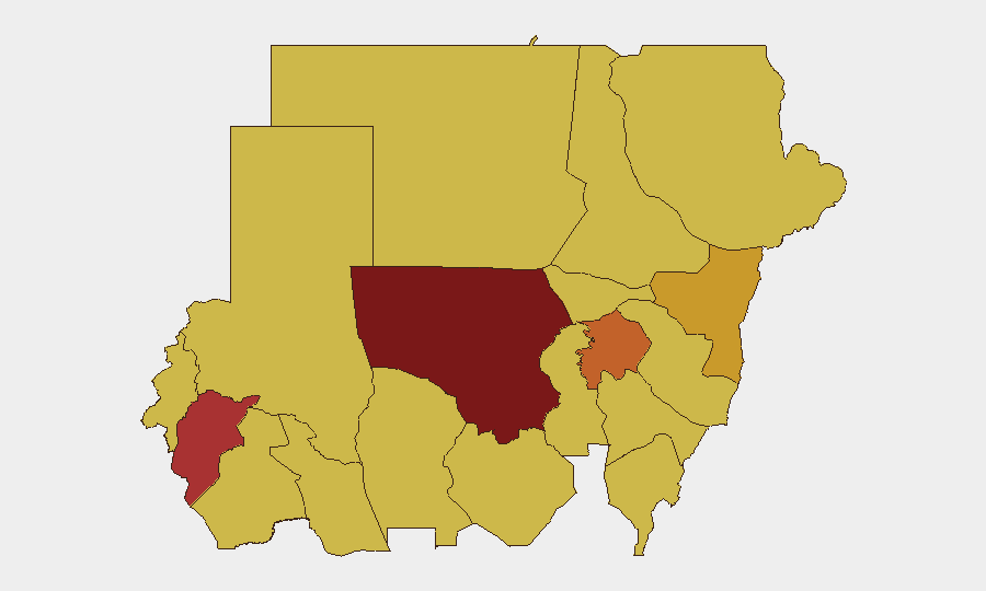
North Kordofan (risk 100) and Central Darfur (78.9) drive the composite threat ranking and are the primary loci of conventional military force and ethnic-violence signals. Kordofan's dominance reflects sustained armed-group and military operations; Darfur's elevation is tied to recent atrocity allegations and population vulnerability. Mid-tier risk zones (Aj Jazira, Kassala, South Kordofan, North Darfur, Blue Nile) form a contiguous belt of conflict exposure, while the capital (Al Khartum, risk 70) and peripheral states (Red Sea, River Nile) show elevated but secondary risk, likely reflecting spillover and governance-control uncertainty rather than active combat.
How GeoBit Would Assist
Security teams should deploy AOI Monitoring & Early Warning on Kordofan and Darfur facilities to trigger alerts on movement, infrastructure change, or signal density spikes ahead of tactical shifts. Network & Actor Analysis and Force Structure mapping would clarify command relationships, supply lines, and front-line stability for asset-protection planning. Conflict & Military battle-mapping and GIS & Spatial Analysis enable routing planners to model alternative evacuation or supply corridors and identify safe corridors or choke points in real time.
7-Day Outlook
No significant ceasefire or military repositioning signals are evident; conflict intensity is expected to remain sustained in Kordofan and Darfur. International pressure (judicial, media, NGO disapproval) may intensify rhetoric but is unlikely to produce immediate operational constraint. Personnel and asset risk in high-ranked zones should be treated as persistent through mid-July unless a formal humanitarian corridor or localized agreement emerges.
Highest-Risk Areas — Ranked
| # | State / Region | Risk |
|---|---|---|
| 1 | North Kordofan State | 100 |
| 2 | Central Darfur State | 78.9 |
| 3 | Aj Jazira | 75.7 |
| 4 | Kassala State | 71.2 |
| 5 | South Kordofan | 70.4 |
| 6 | North Darfur State | 70.4 |
| 7 | Blue Nile | 70 |
| 8 | River Nile State | 70 |
| 9 | Al Khartum | 70 |
| 10 | Red Sea State | 70 |
| 11 | Al Qadarif State | 70 |
| 12 | Sennar State | 70 |
Previous Daily Briefs
A new Sudan brief is written every day — each with its own risk map and downloadable CSV. Here's the last week; use the calendar to go further back.
📅 Browse every day by calendar →
Highlighted days have a brief. Tap a day for that day's map & analysis, or “csv” for that day's dataset ($5).
Atlas — our AI intelligence desk — emails them this snapshot personally. Nothing else, no list.