Situation Summary
Suriname remains a low-threat environment (global rank #174, composite score 4) with no confirmed security incidents or unrest in the last 24–48 hours as of 23 August 2026. Baseline urban crime continues in major population centers, particularly Paramaribo and surrounding districts, but no new discrete events meeting multi-source verification thresholds have emerged in the current reporting window. The security picture is stable; risk remains concentrated in remote interior regions and specific urban crime hotspots rather than systemic instability.
Key Developments
No confirmed new security, crime, unrest, or civil-order incidents in Suriname for 22–23 August 2026. Multi-source search across news, social media (X/Twitter), and police communications has identified no discrete events originating in the last 24–48 hours that meet publication standards for this brief. Ongoing investigations (including a high-profile missing-person case under active police inquiry) predate this window and therefore are classified as background, not current developments. Routine law-enforcement activity and baseline property and street crime continue but do not constitute new situational changes.
Highest-Risk Areas
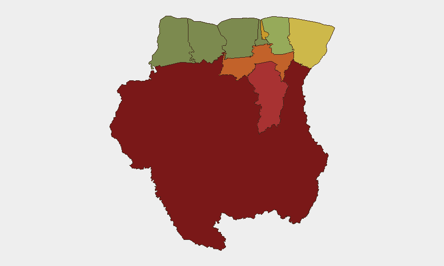
Interior Sipaliwini district (risk 92) and Brokopondo (risk 78) dominate the sub-national threat landscape, driven by limited state presence, remoteness, and criminal activity in mining and trafficking corridors. Paramaribo (risk 71) and Para district (risk 74) follow, reflecting urban crime concentration—armed robbery, theft, and assault—and gang-related activity in densely populated areas. Coastal and western districts (Commewijne, Wanica, Saramacca, Nickerie, Coronie) carry substantially lower risk profiles. Security personnel and expatriate staff should maintain heightened situational awareness in Paramaribo's high-density commercial and residential zones and exercise extreme caution in or transit through interior regions without vetted local coordination.
How GeoBit Would Assist
Intel Sweep and global event feeds provide baseline monitoring for emerging unrest or crime trends; X/Twitter and Telegram OSINT, combined with multi-language search, capture local police bulletins, community warnings, and real-time incident reports often ahead of formal media. AOI Monitoring & Early Warning with persistent watch on Paramaribo's crime hotspots and interior trafficking nodes would generate alerts on pattern changes—e.g., escalation in armed robbery frequency, protest activity, or border incidents—allowing security teams to adjust duty-of-care protocols. Routing & Network Analysis supports alternative-journey planning for personnel transiting high-risk districts or interior areas, reducing exposure to known crime corridors.
7-Day Outlook
No imminent security escalation is anticipated in the next 7 days. Baseline crime patterns are expected to persist in Paramaribo and urban districts; interior regions will remain low-density and high-risk for remote operations. Security posture should remain at current advisory levels, with continued emphasis on urban situational awareness and interior access controls. Any significant political, public-order, or criminal-activity change would be flagged immediately via GeoBit alert channels.
GEOBIT SURINAME RISK LEVEL: 4/10 | STATUS: STABLE
Highest-Risk Areas — Ranked
| # | State / Region | Risk |
|---|---|---|
| 1 | Sipaliwini | 92 |
| 2 | Brokopondo | 78 |
| 3 | Para | 74 |
| 4 | Paramaribo | 71 |
| 5 | Marowijne | 68 |
| 6 | Commewijne | 42 |
| 7 | Wanica | 38 |
| 8 | Saramacca | 29 |
| 9 | Coronie | 12 |
| 10 | Nickerie | 8 |
Sources
- surinamenieuwscentrale.com
- surinamenieuwscentrale.com
- surinamenieuwscentrale.com
- surinamenieuwscentrale.com
- srnieuws.com
- surinamenieuwscentrale.com
- moneycontrol.com
- srnieuws.com
- drimble.nl
- surinamenieuwscentrale.com
- surinamenieuwscentrale.com
- geobit.ai
- thehindu.com
- iol.co.za
- intent.press
- x.com
- whitehouse.gov
- hartvannederland.nl
Previous Daily Briefs
A new Suriname brief is written every day — each with its own risk map and downloadable CSV. Here's the last week; use the calendar to go further back.
- August 20, 2026
- August 18, 2026
- August 16, 2026
- August 14, 2026
- August 12, 2026
- August 10, 2026
- August 8, 2026
📅 Browse every day by calendar →
Highlighted days have a brief. Tap a day for that day's map & analysis, or “csv” for that day's dataset ($5).
Atlas — our AI intelligence desk — emails them this snapshot personally. Nothing else, no list.