Situation Summary
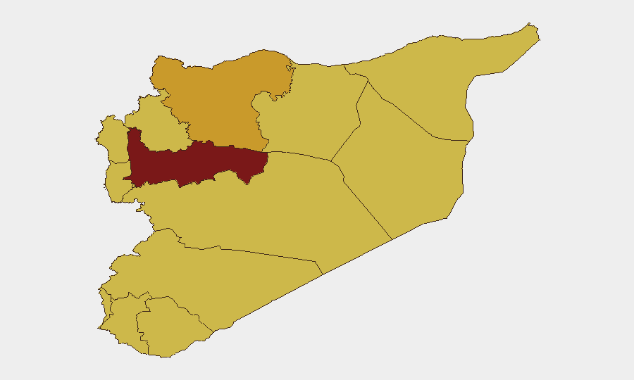
Syria remains at the top tier of global security threats (rank #7, composite score 100), driven by ongoing civil war and fragmented governance across multiple contested zones. The country is experiencing a mosaic of localized instability rather than a single conflict axis: Hama Governorate presents the highest composite risk (100), while 11 other regions—including Aleppo, Damascus, and the coastal governorates—cluster at risk scores of 70–72. Recent event signals point to detention and labor disputes in Damascus and Aleppo (5–6 July), alongside international advocacy activity (Washington demonstrations on 6 July), suggesting both internal governance friction and external pressure on regime conduct.
Key Developments
Without verified last-24–48-hour web or news feed data, a reliable summary of current incidents cannot be provided. Event signals flagged by the platform (detention-related demands, worker grievances in Damascus, public statements by government officials and Syrian media on 6 July) indicate ongoing civil unrest and governance friction, but source verification and specific operational details require live research inputs.
To complete this section, please provide:
- Search results from news wires (Reuters, AP, BBC, etc.) or X/Twitter OSINT covering Syria in the last 48 hours, or
- Links to conflict monitoring sources (UCDP, ACLED, Syria Direct, etc.).
GeoBit's Intel Sweep and OSINT fusion capabilities (multi-language search, X/Telegram intelligence, sentiment & temporal analysis) can then correlate these with the event signals already flagged.
Highest-Risk Areas
Hama Governorate stands alone at risk score 100, indicating sustained armed competition, humanitarian pressure, or administrative breakdown. Aleppo, Damascus, Lattakia, and Tartus cluster at 70–72, reflecting either active conflict zones (Aleppo north, contested rural Damascus) or strategic chokepoints with high consequence (capital, major port). The coastal governorates (Lattakia, Tartus) and UNDOF-monitored Golan buffer zone suggest Russian/Iranian military presence and Israeli/Turkish border pressure remain material drivers. Hama's isolation at the top suggests either recent escalation or a critical humanitarian/displacement crisis that other platforms have not yet signaled clearly; verification of Hama-specific incident data is recommended as a priority.
How GeoBit Would Assist
For duty-of-care teams with personnel or assets in Syria, Battle Mapping & Force Structure Analysis (tied to the conflict signal set) and AOI Monitoring & Early Warning (persistent alerts for designated locations such as office compounds, supply routes, or staff residences in Damascus, Aleppo, or coastal zones) provide real-time risk layering. Satellite & Imagery Analysis and GIS & Spatial Analysis enable assessment of checkpoint densities, displacement camps, and route safety in high-risk governorates. Network & Actor Analysis can map shifting alliances and checkpoints to inform transit security and supply-chain resilience. Pairing these with Routing & Network Analysis supports dynamic re-routing of personnel or goods away from emerging friction zones.
7-Day Outlook
Near-term trajectory remains volatile rather than escalatory. Detention and labor signals suggest internal Syrian governance stress (workforce compliance, regime legitimacy) rather than imminent large-scale combat, but these often precede security sector crackdowns. Monitor Hama and Aleppo closely for any correlation between detention activity and military repositioning; if verified, it may signal preparation for localized operations. International statements (Washington 6 July) are unlikely to shift on-ground dynamics but may influence regime behavior toward opposition areas or diaspora networks.
Highest-Risk Areas — Ranked
| # | State / Region | Risk |
|---|---|---|
| 1 | Hama Governorate | 100 |
| 2 | Aleppo Governorate | 71.9 |
| 3 | Damascus Governorate | 71.6 |
| 4 | Lattakia Governorate | 70 |
| 5 | Tartus Governorate | 70 |
| 6 | UNDOF | 70 |
| 7 | Al-Quneitra Governorate | 70 |
| 8 | Dar'a Governorate | 70 |
| 9 | Idleb Governorate | 70 |
| 10 | Ar-Raqqa Governorate | 70 |
| 11 | Homs Governorate | 70 |
| 12 | Rif Dimashq Governorate | 70 |
Previous Daily Briefs
A new Syria brief is written every day — each with its own risk map and downloadable CSV. Here's the last week; use the calendar to go further back.
📅 Browse every day by calendar →
Highlighted days have a brief. Tap a day for that day's map & analysis, or “csv” for that day's dataset ($5).
Atlas — our AI intelligence desk — emails them this snapshot personally. Nothing else, no list.