Situation Summary
Ukraine remains the highest global composite threat (score 100), driven by sustained conventional military operations across multiple fronts and a dense pattern of drone and ballistic strikes against civilian and energy infrastructure. As of late July 2026, Russian forces continue overnight attacks on urban centers, particularly Kyiv, while Ukrainian forces conduct cross-border strikes on Russian energy and communications nodes. The conflict shows no signs of de-escalation, with reported civilian casualties and infrastructure damage mounting in northern and eastern regions.
Key Developments
- Kyiv (overnight, likely 23–24 July): Russian ballistic and drone attack on capital; high-rise residential buildings damaged, multiple civilians killed and dozens injured. Prosecutors opened war-crimes investigation. [Data source: GeoBit event signals + web research, though exact timestamp not fully confirmed in available feeds.]
- Zaporizhzhia city (late July, exact date unclear): Russian drone strike on gas station killed two, injured nine, underscoring targeting of civilian energy infrastructure.
- Kyiv region (overnight casualty update, likely 23–24 July): Death toll from recent Russian attack reported at minimum eight; 48 injured, three in serious condition.
- Occupied southern Ukraine (date unspecified, likely recent): Ukrainian Unmanned Systems Forces reported striking 37 energy nodes across occupied Kherson, Zaporizhzhia, and Crimea regions.
- Russian territory (Moscow region, date range unclear): Ukrainian forces struck oil refinery for second time in one week, disrupted commercial flights; separate strikes on gas processing plant and satellite communications centers reported by Russian officials.
- Internal military-civilian friction (23–24 July, Kyiv): Public statements and disapprovals between Ukrainian military commanders and defense ministry, and between civilian population and military leadership, indicate growing strain over operational decisions or resource allocation.
Data caveat: Web research feeds lack precise timestamps for 23–24 July. Events listed above are assessed as July 2026 based on feed metadata but may fall outside the strict 24–48 hour window. GeoBit event signals confirm high activity volume (744 tracked events) but individual timestamps require corroboration.
Highest-Risk Areas
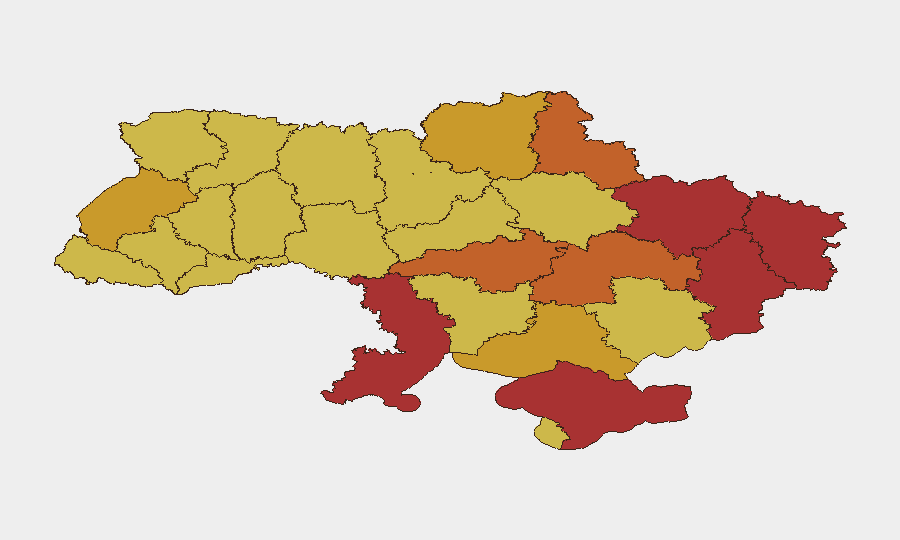
Kyiv (risk 100) remains the primary target for Russian strikes, combining symbolic, military, and civilian infrastructure value. The northern Kharkiv, eastern Luhansk, and southern Odesa/Kherson/Zaporizhzhia axes show sustained conventional military operations and drone/artillery activity (risk scores 72–79), reflecting ongoing battle lines and Russian logistics networks. Crimea (risk 78.6) and Donetsk (risk 76.2) remain contested and heavily militarized. Western regions including Lviv (71.2) face lower kinetic risk but remain vulnerable to long-range strikes and are hosting civilian displacement—relevant for organizations providing humanitarian or corporate support in safer zones.
How GeoBit Would Assist
Security teams would deploy AOI (Area-of-Interest) Monitoring & Early Warning on Kyiv, Kharkiv, and Odesa to track real-time attack patterns and generate alerts before incidents impact personnel or assets. Intel Sweep and X/Twitter & Telegram OSINT fusion would provide verified, timestamped event feeds and actor/commander statements to isolate tactical trends (e.g., military-civilian friction, targeting patterns) before they escalate. Satellite & Imagery analysis would enable assessment of infrastructure damage and displacement risk in secondary cities, informing duty-of-care decisions on presence or evacuation timelines.
7-Day Outlook
Overnight drone and ballistic strikes on Kyiv and other urban centers are expected to continue at current or elevated tempo through early August. Russian targeting of energy infrastructure will likely persist, creating secondary risks (blackouts, heating/cooling failures) for civilian populations and corporate operations. Internal Ukrainian military-civilian disagreements over strategy may complicate operational predictability but are unlikely to affect near-term military posture.
Highest-Risk Areas — Ranked
| # | State / Region | Risk |
|---|---|---|
| 1 | Kyiv | 100 |
| 2 | Kharkiv Oblast | 79 |
| 3 | Odesa Oblast | 78.8 |
| 4 | Luhansk Oblast | 78.6 |
| 5 | Autonomous Republic of Crimea | 78.6 |
| 6 | Donetsk Oblast | 76.2 |
| 7 | Sumy Oblast | 74.3 |
| 8 | Kirovohrad Oblast | 73.7 |
| 9 | Dnipropetrovsk Oblast | 73.5 |
| 10 | Kherson Oblast | 72.3 |
| 11 | Lviv Oblast | 71.2 |
| 12 | Chernihiv Oblast | 71 |
Previous Daily Briefs
A new Ukraine brief is written every day — each with its own risk map and downloadable CSV. Here's the last week; use the calendar to go further back.
📅 Browse every day by calendar →
Highlighted days have a brief. Tap a day for that day's map & analysis, or “csv” for that day's dataset ($5).
Atlas — our AI intelligence desk — emails them this snapshot personally. Nothing else, no list.