Situation Summary
Angola's national security posture remains stable, with no major incidents recorded in the past 24–48 hours. The country ranks #47 globally (composite threat score 35) and presents a baseline security environment characterized by persistent regional fragmentation rather than acute national crisis. Environmental hazards—particularly widespread wildfires across multiple provinces—remain operationally significant but are distinct from conflict or civil-unrest risks. Corporate and expatriate personnel in Luanda and central economic zones face low immediate threat, though sub-national disparities are pronounced.
Key Developments
No security, conflict, or civil-unrest incidents meeting verified, time-stamped criteria for the 24–48 hours ending 25 July 2026 have been corroborated across independent open-source channels. The most recent documented national security assessment (19 July 2026) recorded no acute incidents in its preceding window and no indication of deterioration since that date.
Environmental & Operational Impact (ongoing, unspecific date):
- At least 10 active wildfires confirmed across Benguela, Cuando Cubango, Cunene, and Luanda provinces; flood-response operations remain active in several regions. These do not constitute security events but affect road access, air quality, and logistics planning.
Regional Baseline (context):
- Diplomatic tension with Bharat noted in a public statement dated 24 July 2026; substance and implications require further monitoring but no security escalation reported as of brief time.
Highest-Risk Areas
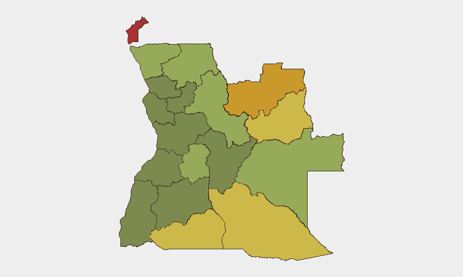
Cabinda Province (risk 78) and Lunda Norte (72) anchor Angola's sub-national threat profile and drive the national composite score. Both regions carry longstanding exposure to organized crime, smuggling networks, and cross-border instability; Cabinda's historical separatist tensions and oil-sector vulnerability remain structurally significant. The southern and eastern provinces—Lunda Sul, Cuando Cubango, Cunene, and Moxico (risk scores 68–58)—present overlapping risks of border permeability, wildlife trafficking, and mineral-sector security challenges. Central provinces (Huambo, Uíge, Malanje, Bié) and the southern zone (Huíla) show materially lower risk but remain subject to crime and localized civil-society tensions. Luanda itself, though not disaggregated in sub-national rankings, benefits from concentrated state capacity but hosts both organized crime and periodic protest activity.
How GeoBit Would Assist
Security teams protecting personnel or assets in Angola would benefit from Intel Sweep and global event feeds to capture emerging civil-unrest, crime, or political signals in near-real time, coupled with X/Twitter and Telegram OSINT to track activist and opposition sentiment in Luanda and provincial capitals. AOI Monitoring & Early Warning on Cabinda, the Lundas, and Cuando Cubango—with customized alerting for security incidents, border-crossing anomalies, or infrastructure disruption—would provide persistent situational awareness without daily manual review. Routing & Network Analysis supports contingency travel planning around active wildfires and flood zones, while Network & Actor Analysis clarifies organized-crime and smuggling patterns in high-risk provinces, informing site-security posture and supply-chain resilience.
7-Day Outlook
No indicators suggest imminent escalation of conflict, mass protest, or major infrastructure failure at the national level in the next seven days. Environmental hazards (wildfires, flooding) will likely persist and may affect provincial logistics and air quality, requiring operational flexibility. Diplomatic friction with Bharat warrants continued monitoring but does not yet signal security or economic disruption to foreign nationals or commercial operations.
Highest-Risk Areas — Ranked
| # | State / Region | Risk |
|---|---|---|
| 1 | Cabinda Province | 78 |
| 2 | Lunda Norte Province | 72 |
| 3 | Lunda Sul Province | 68 |
| 4 | Cuando Cubango Province | 64 |
| 5 | Cunene Province | 62 |
| 6 | Moxico Province | 58 |
| 7 | Zaire Province | 54 |
| 8 | Huambo Province | 50 |
| 9 | Uíge Province | 48 |
| 10 | Malanje Province | 42 |
| 11 | Bié Province | 35 |
| 12 | Huíla Province | 32 |
Sources
Previous Daily Briefs
A new Angola brief is written every day — each with its own risk map and downloadable CSV. Here's the last week; use the calendar to go further back.
📅 Browse every day by calendar →
Highlighted days have a brief. Tap a day for that day's map & analysis, or “csv” for that day's dataset ($5).
Atlas — our AI intelligence desk — emails them this snapshot personally. Nothing else, no list.