Situation Summary
Benin remains classified as a moderate global terrorism and insurgency risk (#54 globally, composite score 33), with no confirmed security incidents in the last 24–48 hours. The threat environment is concentrated in the northern departments, where ISIS-affiliated and other militant groups maintain operational presence along porous borders with Niger and Burkina Faso. Background risk remains stable; no escalation or major incident has been detected in the current reporting window.
Key Developments
- No confirmed incidents in last 24–48 hours. Web research and OSINT feeds have not surfaced discrete security, crime, or civil-unrest events dated 7–8 August 2026 in Benin. Historical advisory and background reporting dominate available sources.
- Northern militant activity remains baseline. German foreign office and multi-source travel advisories (dated June 2026 and earlier) continue to flag endemic terrorist activity, kidnapping risk, and periodic attacks in Alibori, Atakora, and Donga departments, but no new incidents are confirmed in this window.
- Digital law-enforcement activity noted (limited scope). A recent social-media post references a TikTok investigation by Beninese authorities related to online conduct; however, this is a judicial/regulatory matter, not a public-security or instability event affecting corporate or expatriate duty-of-care risk.
Highest-Risk Areas
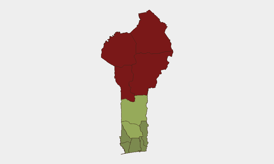
Alibori (risk 92), Atakora (88), and Donga (85) departments drive Benin's overall threat profile. All three border Niger and Burkina Faso and host active ISIS-affiliated and non-state armed groups responsible for episodic kidnappings, armed robbery, and clashes with national forces. Borgou Department (83) presents similar cross-border vulnerabilities. Zou Department (45), though significantly lower-risk, merits monitoring as a secondary corridor. The southern coastal and central departments (Ouémé, Littoral, Atlantique) remain substantially lower-risk and suitable for routine corporate operations.
How GeoBit Would Assist
Security teams managing personnel or assets in Benin should employ AOI Monitoring & Early Warning focused on the four highest-risk northern departments to detect emerging militant activity, roadblocks, or security force operations in near-real time. Intel Sweep (global event feeds, X/Telegram OSINT, and multi-language source fusion) combined with Conflict & Military tracking would provide continuous baseline awareness of armed-group disposition, recruitment signals, and attack patterns. Routing & Network Analysis enables alternative journey planning and security checkpoints avoidance for any essential travel through affected zones.
7-Day Outlook
No imminent escalation is anticipated. Benin's security environment is expected to remain at baseline—characterized by persistent but geographically confined militant activity in the north and routine governance/policing in the south and center. Seasonal factors (late rainy season) may reduce operational tempo in remote areas but do not materially reduce underlying kidnapping or ambush risk in designated high-risk departments. Standard duty-of-care protocols (avoidance of northern border zones, travel vetting, local-security liaison) remain appropriate for corporate teams.
Highest-Risk Areas — Ranked
| # | State / Region | Risk |
|---|---|---|
| 1 | Alibori Department | 92 |
| 2 | Atakora Department | 88 |
| 3 | Donga Department | 85 |
| 4 | Borgou Department | 83 |
| 5 | Zou Department | 45 |
| 6 | Collines Department | 42 |
| 7 | Plateau Department | 38 |
| 8 | Kouffo Department | 35 |
| 9 | Mono Department | 32 |
| 10 | Atlantique Department | 28 |
| 11 | Littoral | 25 |
| 12 | Ouémé Department | 22 |
Sources
Previous Daily Briefs
A new Benin brief is written every day — each with its own risk map and downloadable CSV. Here's the last week; use the calendar to go further back.
📅 Browse every day by calendar →
Highlighted days have a brief. Tap a day for that day's map & analysis, or “csv” for that day's dataset ($5).
Atlas — our AI intelligence desk — emails them this snapshot personally. Nothing else, no list.