Situation Summary
Chad remains classified at global threat rank #18 (composite score 94) with persistent multidomain security fragmentation spanning terrorism, armed groups, violent crime, and border instability. The U.S. State Department maintains a Level 4 "Do Not Travel" advisory countrywide. No major new incidents have been verified in open sources in the last 24–48 hours; the current threat posture reflects structural risk factors—heightened internal security enforcement, ongoing counterterrorism restrictions in Lake Province, and sustained cross-border spillover—rather than acute escalation.
Key Developments
- Countrywide – 15 July 2026: U.S. Department of State reaffirmed Level 4 "Do Not Travel" advisory, citing terrorism, kidnapping, and violent crime as persistent threats to foreign nationals across Chad.
- Countrywide – 14 July 2026: GeoBit Intelligence flagged a new national-level arrest/detention incident with unconfirmed details, assessed as part of a broader trend of heightened internal security actions by authorities.
- Lac Province (Lake Chad region) – ongoing since 7–8 May 2026, in force as of mid-July 2026: State of emergency and nightly curfew (20:00–06:00) remain active; boat/pirogue use banned 18:00–06:00 following a May terrorist attack on a military installation.
- N'Djamena – current as of mid-July 2026: Violent crime risk remains very high; police conducting intensified evening checks for illegal weapons; armed robbery and assault documented countrywide, including in the capital.
- Border regions – current as of mid-July 2026: All travel advisories warn against travel to border areas with Nigeria, Cameroon, Niger, Central African Republic, Libya, and Sudan, citing terrorist threats, armed groups, and cross-border conflict spillover. Lake Chad region and provinces including Borkou, Tibesti, Ennedi, Wadi Fira, Ouaddaï, and Sila flagged as highest-risk zones.
- Countrywide governance and security fragmentation – 10 July 2026: GeoBit assessment identifies persistent fragmentation in security, governance, and cross-border control, with military forces heavily deployed along Niger and Cameroon borders; no short-term de-escalation signals detected.
Highest-Risk Areas
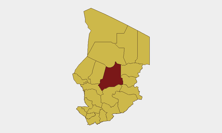
Batha Province (risk score 96.1) is the single highest-risk region, driven by terrorist activity, armed-group presence, and limited state control. Nine provinces—Ennedi-Ouest, Wadi Fira, Ouaddaï, Sila, Salamat, East Ennedi, Kanem, Lac, and N'Djamena—cluster at risk score 66.1, reflecting widespread exposure to cross-border terrorism, kidnapping networks, and violent crime. The Lac Province state of emergency and curfew remain active indicators of sustained counterterrorism pressure. Border zones amplify risk due to porous boundaries, armed-group transit, and Boko Haram/ISIS-affiliated presence in the Lake Chad Basin.
How GeoBit Would Assist
Security teams should deploy GeoBit's Area-of-Interest (AOI) Monitoring & Early Warning against Batha, Lac, and border provinces to detect real-time activity changes and receive alerts on armed-group movement or security-force deployment. Conflict & Military mapping and battle mapping enable tracking of military force concentrations along Niger and Cameroon borders and assessment of counterterrorism posture. OSINT fusion and multi-language search across Telegram, Twitter, and local media provide early signals of detention campaigns, curfew enforcement changes, or cross-border incidents before mainstream reporting.
7-Day Outlook
No imminent major escalation is signaled in available data; risk trajectory remains stable within a persistently elevated baseline. Authorities' heightened internal security actions and active counterterrorism measures in Lac suggest continued operational tempo. Monitor for changes in curfew enforcement, border-force posture, or detention trends; any easing of restrictions could signal reduced immediate threat perception, while intensification would indicate escalating state concern.
Highest-Risk Areas — Ranked
| # | State / Region | Risk |
|---|---|---|
| 1 | Batha | 96.1 |
| 2 | Ennedi-Ouest | 66.1 |
| 3 | Wadi Fira | 66.1 |
| 4 | Ouaddaï | 66.1 |
| 5 | Sila | 66.1 |
| 6 | Salamat | 66.1 |
| 7 | East Ennedi | 66.1 |
| 8 | Kanem | 66.1 |
| 9 | Lac | 66.1 |
| 10 | N'Djamena | 66.1 |
| 11 | Hadjer-Lamis | 66.1 |
| 12 | Chari-Baguirmi | 66.1 |
Sources
Previous Daily Briefs
A new Chad brief is written every day — each with its own risk map and downloadable CSV. Here's the last week; use the calendar to go further back.
📅 Browse every day by calendar →
Highlighted days have a brief. Tap a day for that day's map & analysis, or “csv” for that day's dataset ($5).
Atlas — our AI intelligence desk — emails them this snapshot personally. Nothing else, no list.