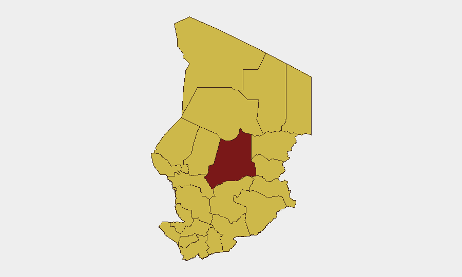
Situation Summary
Chad faces sustained jihadist pressure across its Lake Chad basin, with Boko Haram and ISIS-linked cells conducting coordinated raids, mine attacks, and cross-border operations that have killed dozens of soldiers and civilians in the past week alone. Urban security in N'Djaména remains fragile, with reports of armed assault on commuters near military installations highlighting broader law-enforcement gaps. The US State Department maintains a Level 4 "Do Not Travel" advisory for all of Chad, and military authorities have declared emergency regimes in Lac Province to counter ongoing offensive operations. Trajectory remains acute over the near term.
Key Developments
- Kalam, Lac Province (15 July, ~1400 local): Jihadist-planted anti-vehicle mine detonated beneath a Chadian security forces vehicle, killing 8–9 soldiers and wounding 10–21; subsequent armed clashes erupted the same day near Bakaram, ~25 km south, indicating sustained militant presence in the Lake Chad–Nigeria border zone.
- Bagassola sub-prefecture, Lake Chad (16 July, ~0500 local): Boko Haram militants attacked fishermen on an island near Bagassola, killing 7 civilians and 10 attackers in a firefight with Chadian counter-terrorism forces; incident reflects persistent jihadist capability to strike mixed civilian–military targets across open water.
- N'Djaména, Camp 27 corridor (15 July, ~2200 local): Unidentified assailants attacked a motorcyclist near Camp 27 on the Farcha–Amriguebé route, forcing a traffic accident; victim evacuated to Central Hospital and assailants fled. Incident prompted public calls for reinforced policing in the corridor, exposing night-time urban crime risk near critical military infrastructure.
- Lake Chad basin, cross-border intelligence (mid-July, timing uncertain but reported 16–17 July): Nigerian military forces captured an ISIS-linked Moroccan operative in the Abadam sector following a failed assault in Borno State; arrest underscores transnational jihadist network activity and potential coordination across Chad–Nigeria frontier.
- Lac Province emergency posture (15–18 July, ongoing): Chadian military has declared emergency measures and reinforced deployments along the Lake Chad–Nigeria border in direct response to mine attacks and raids; movement restrictions now in effect for civilian and commercial traffic.
Highest-Risk Areas
Batha Province (risk score 95.5) is the single highest-risk administrative zone, though the broader eastern and northern tier—Ennedi-Ouest, Wadi Fira, Ouaddaï, Sila, Salamat, East Ennedi, and Lac—all register at 65.5, indicating widespread jihadist operational presence. Lac Province is currently the most kinetically active theater, with three confirmed militant attacks (mine, raid, and cross-border operations) in the past 72 hours. N'Djaména itself (risk 65.5) shows vulnerability to armed street crime near military installations. The eastern and northern regions remain semi-ungoverned or lightly controlled, providing sanctuary for Boko Haram and ISIS franchises.
How GeoBit Would Assist
Security teams should deploy AOI Monitoring & Early Warning on Lac Province, Batha, and the Lake Chad–Nigeria frontier corridor to detect militant staging, vehicle movement, and supply-line activity before major attacks. Conflict & Military mapping and force-structure tracking will clarify Chadian deployments and gaps, informing personnel routing and asset positioning. Routing & Network Analysis should identify alternative transport corridors in N'Djaména and surrounding zones to avoid high-crime and military-sensitive areas during hours of heightened risk.
7-Day Outlook
Jihadist tempo is likely to remain elevated through late July as groups capitalize on the monsoon season (reduced aerial/surveillance capability) and exploit military redeployments following the Kalam mine strike. Expect continued raids on soft targets (fishermen, herders, isolated patrols) in Lac and Ennedi provinces. Urban security incidents in N'Djaména may increase if militants attempt to signal capability or if local criminal networks exploit police redistribution toward border zones.
Highest-Risk Areas — Ranked
| # | State / Region | Risk |
|---|---|---|
| 1 | Batha | 95.5 |
| 2 | Ennedi-Ouest | 65.5 |
| 3 | Wadi Fira | 65.5 |
| 4 | Ouaddaï | 65.5 |
| 5 | Sila | 65.5 |
| 6 | Salamat | 65.5 |
| 7 | East Ennedi | 65.5 |
| 8 | Kanem | 65.5 |
| 9 | Lac | 65.5 |
| 10 | N'Djamena | 65.5 |
| 11 | Hadjer-Lamis | 65.5 |
| 12 | Chari-Baguirmi | 65.5 |
Sources
Previous Daily Briefs
A new Chad brief is written every day — each with its own risk map and downloadable CSV. Here's the last week; use the calendar to go further back.
📅 Browse every day by calendar →
Highlighted days have a brief. Tap a day for that day's map & analysis, or “csv” for that day's dataset ($5).
Atlas — our AI intelligence desk — emails them this snapshot personally. Nothing else, no list.