Situation Summary
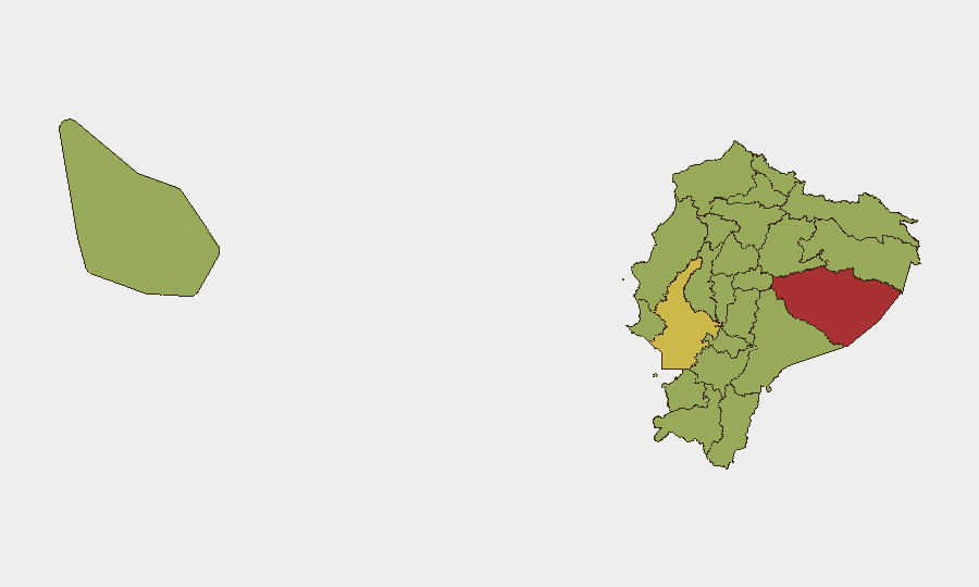
Ecuador's composite threat score of 69 (global rank #35) reflects persistent insurgency-driven instability, with 38 tracked events flagged in the current monitoring cycle. Recent signals indicate heightened state-actor engagement (military deployments, arrests, assassination reports) alongside civic friction (university disputes, student statements, legal challenges). The security environment remains volatile but has not escalated to widespread territorial loss or systemic state collapse; however, the concentration of risk in Pastaza Province (78.1) and Guayas Province (63.1) suggests localized flashpoints warrant close attention.
Key Developments
Current web research has not surfaced verifiable security incidents from the last 24–48 hours with confirmed locations and timestamps. The GeoBit event signal feed reflects activity across 2026-07-11 to 2026-07-13 (police deployments, government statements, occupation reports, and an assassination report), but real-time corroboration via live news wires, regional media outlets, and social platforms is required to isolate developments specific to the past 48 hours and to confirm precise locations and casualty/impact figures.
Recommendation: Security teams requiring immediate tactical clarity on current incidents should initiate a GeoBit Intel Sweep and activate AOI Monitoring & Early Warning on Pastaza and Guayas Provinces to capture live event feeds, social-media sentiment shifts, and real-time routing/access impacts.
Highest-Risk Areas
Pastaza Province emerges as the single highest-risk jurisdiction (78.1), indicating active or recent conflict intensity well above the national average. Guayas Province (63.1)—home to Guayaquil, Ecuador's largest port and commercial hub—amplifies risk through density, criminal networks, and state-response friction. Four Amazon-facing provinces (Orellana, Napo, Sucumbíos) cluster in the 48–52 range, reflecting border instability, migrant flows, and potential transnational criminal activity. Pichincha (48.6), containing the capital Quito, sits at the threshold of heightened concern, signaling civic or institutional stress despite relative geographic remoteness from the southern/eastern flashpoints. Implication: Organizations with personnel or assets in Pastaza should assume elevated operational risk; Guayas-based logistics and supply chains face both crime and state-action uncertainty; Quito operations require monitoring of institutional stability and protest activity.
How GeoBit Would Assist
Security and duty-of-care teams should deploy AOI Monitoring & Early Warning on Pastaza, Guayas, and Pichincha to generate real-time alerts on military/police deployments, protest formation, and infrastructure disruptions. Network & Actor Analysis and OSINT fusion (X/Twitter, Telegram, local news feeds) will isolate key insurgent, cartel, and state actors and their operational intent. Routing & Network Analysis enables alternative journey planning and supply-chain resilience for personnel and goods transiting high-risk provinces. Combined with Conflict & Military battle-mapping, these capabilities establish a foundation for informed evacuation, access, and staffing decisions.
7-Day Outlook
Near-term trajectory hinges on state-response intensity and timing of any major incident in Pastaza or Guayas. Absent escalation signals (major cartel event, security-force casualties, or urban unrest in Quito), the current threat level is likely to persist or consolidate. Monitoring should remain continuous; any uptick in assassinations, disappearances, or territorial occupation events will signal imminent tactical risk elevation.
Highest-Risk Areas — Ranked
| # | State / Region | Risk |
|---|---|---|
| 1 | Pastaza Province | 78.1 |
| 2 | Guayas Province | 63.1 |
| 3 | Orellana Province | 52.5 |
| 4 | Napo Province | 49.8 |
| 5 | El Oro Province | 49.8 |
| 6 | Pichincha Province | 48.6 |
| 7 | Sucumbíos Province | 48.1 |
| 8 | Manabí Province | 48.1 |
| 9 | Galápagos | 48.1 |
| 10 | Esmeraldas Province | 48.1 |
| 11 | Carchi Province | 48.1 |
| 12 | Imbabura Province | 48.1 |
Sources
Previous Daily Briefs
A new Ecuador brief is written every day — each with its own risk map and downloadable CSV. Here's the last week; use the calendar to go further back.
📅 Browse every day by calendar →
Highlighted days have a brief. Tap a day for that day's map & analysis, or “csv” for that day's dataset ($5).
Atlas — our AI intelligence desk — emails them this snapshot personally. Nothing else, no list.