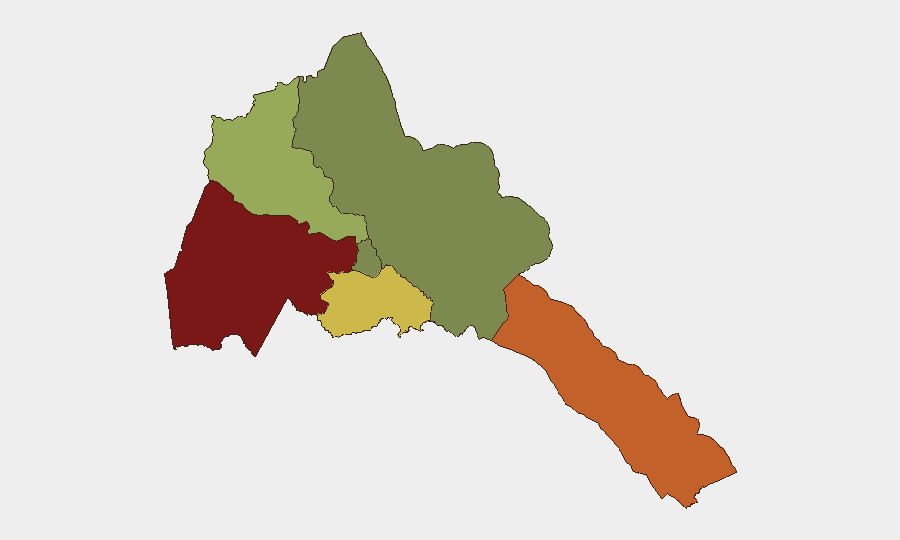
Situation Summary
Eritrea maintains a composite threat ranking of 24 globally (#71), with no verified security incidents reported in the last 24–48 hours as of 19 August 2026. Structural risk remains concentrated in the western and southern regions (Gash-Barka, Southern Red Sea Region, and Debub), driven by persistent border tensions, limited state capacity, and regional instability spillover from Sudan and Ethiopia. The security environment is characterized by chronic rather than acute threat patterns; the absence of reported incidents does not indicate reduced underlying vulnerability in high-risk zones.
Key Developments
- No discrete security, conflict, crime, or infrastructure incidents were identified in Eritrea during the 24–48 hour window ending 19 August 2026 across verified news, social media, broadcast, and dedicated security feeds.
- Regional geopolitical context (Sudan conflict spillover, Ethiopia relations, Red Sea maritime dynamics) continues to influence Eritrea's strategic posture but has not generated location-specific incidents on Eritrean soil in the current reporting window.
- Maekel Region (risk score 18) and Northern Red Sea Region (risk score 0) remain the lowest-risk operational zones for international personnel and business activity.
Highest-Risk Areas
Gash-Barka (risk 92) and Southern Red Sea Region (risk 75) together account for the majority of assessed country risk. Gash-Barka's elevation is driven by proximity to the Sudan border, limited administrative reach, informal cross-border movement, and historical dispute-settlement challenges; Southern Red Sea Region faces similar border-adjacent vulnerabilities and maritime operational constraints. Debub Region (risk 68) presents moderate but measurable risk related to internal security capacity and regional spillover. By contrast, Maekel Region (the capital zone) and Northern Red Sea Region present minimal acute risk to standard corporate operations.
How GeoBit Would Assist
Security and duty-of-care teams can deploy Area-of-Interest (AOI) Monitoring & Early Warning on Gash-Barka and Southern Red Sea Region to generate automated alerts for emerging incidents, protest activity, or infrastructure disruption before they impact operations. OSINT Fusion & Corroboration (combining X/Twitter, Telegram, local media, and radio SIGINT) would detect early warning signals—including cross-border military activity or informal security incidents—that do not immediately appear in international news. Routing & Network Analysis can generate secure, real-time alternative routing and supply-chain options for personnel and assets in medium-risk areas, minimizing exposure to identified hotspots while maintaining operational continuity.
7-Day Outlook
No imminent escalation is forecast over the next seven days based on current signals. The security environment is expected to remain consistent with the chronic regional risk profile—low acute-incident probability but sustained structural vulnerabilities in border and southern zones. Monitoring of Sudan developments and Red Sea maritime activity should continue as secondary early-warning indicators for potential spillover.
Highest-Risk Areas — Ranked
| # | State / Region | Risk |
|---|---|---|
| 1 | Gash-Barka | 92 |
| 2 | Southern Red Sea Region | 75 |
| 3 | Debub Region | 68 |
| 4 | Anseba | 55 |
| 5 | Maekel Region | 18 |
| 6 | Northen Red Sea Region | 0 |
Sources
Previous Daily Briefs
A new Eritrea brief is written every day — each with its own risk map and downloadable CSV. Here's the last week; use the calendar to go further back.
- August 17, 2026
- August 15, 2026
- August 13, 2026
- August 11, 2026
- August 9, 2026
- August 7, 2026
- August 6, 2026
📅 Browse every day by calendar →
Highlighted days have a brief. Tap a day for that day's map & analysis, or “csv” for that day's dataset ($5).
Atlas — our AI intelligence desk — emails them this snapshot personally. Nothing else, no list.