Situation Summary
Ethiopia remains in active civil conflict with a composite threat score of 85 (rank #12 globally), driven by armed clashes, government crackdowns, and inter-communal violence spanning multiple regions. No new discrete security incidents have been corroborated in the last 24–48 hours; however, the baseline threat environment remains elevated across northern and eastern zones due to ongoing armed group activity and state military operations. International pressure is mounting, with the U.S. and ICC prosecutor issuing formal disapprovals on 24 July in response to alleged conduct violations. Disease outbreaks (Marburg, malaria) present a secondary public-health risk layer.
Key Developments
- 24–25 July 2026 – Diplomatic/Legal: U.S. State Department issued formal disapproval of Ethiopian government conduct (2 separate statements); ICC prosecutor issued separate public statement on 24 July. Neither announcement specifies a single localized incident but reflects broader concerns over civil conflict conduct and governance.
- 24 July 2026 – Legal: ICC prosecutor issued formal disapproval of Ethiopian government; timeline and specific allegations not yet detailed in open sources.
- Status – Last 24–48 hours: Multi-source monitoring (consolidated security bulletins, live web corroboration) has identified no new confirmed military clashes, communal violence incidents, or kidnappings with specific dates and locations in the 24–26 July window. Earlier incidents (early-to-mid July) in Amhara, Tigray, Oromia, and Somali regions remain on file but fall outside the current reporting period.
- Public-Health Alert (ongoing): Marburg virus disease and malaria cases continue to be reported; exact locations and case counts require verification through health ministry channels.
*Note: Absence of new confirmed incidents in 24–48h does not indicate de-escalation; persistent conflict in multiple regions means risk remains high and further developments are probable.*
Highest-Risk Areas
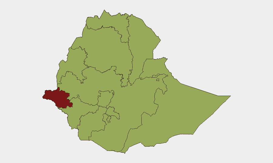
Gambela Region (risk 59.3–89.3) emerges as the single highest-risk sub-national zone, driven by conventional military force activity, inter-communal conflict, and limited state presence. Tigray, Amhara, Afar, Benishangul-Gumuz, and Somali regions each score 59.3, reflecting sustained armed clashes, displacement, and humanitarian access constraints. Addis Ababa itself carries an identical 59.3 risk score, indicating that security threats (civil unrest, targeted violence, checkpoints) extend to the capital and transport corridors. The concentration of high risk across northern (Tigray, Amhara, Afar) and eastern (Somali) zones, plus Addis Ababa, suggests that any corporate presence outside the immediate diplomatic/hotel districts faces elevated duty-of-care exposure.
How GeoBit Would Assist
Security teams with Ethiopia exposure should deploy AOI Monitoring & Early Warning on Gambela, Amhara, Tigray, and Somali regions to detect military or communal-violence signals in real time, paired with Intel Sweep (global event feeds, X/Twitter OSINT, multi-language search) for rapid incident verification and false-positive filtering. Conflict & Military battle-mapping and Satellite & Imagery analysis enable tracking of force movements and displacement patterns around high-risk corridors; Routing & Network Analysis supports safe-passage planning for personnel and supply chains. Health/environmental monitoring can integrate disease outbreak tracking (Marburg, malaria) alongside security risk to support holistic duty-of-care decisions.
7-Day Outlook
No immediate tactical escalation is visible in 24–48h reporting; however, the combination of active civil conflict, international diplomatic disapprovals, and disease outbreaks suggests persistent volatility over the coming week. Expect continued asymmetric military activity in northern and eastern regions, possible further ICC or U.S. statements, and evolving health alerts. Risk remains at elevated baseline; any corporate or NGO movement should be informed by real-time AOI monitoring and conflict-mapping updates.
Highest-Risk Areas — Ranked
| # | State / Region | Risk |
|---|---|---|
| 1 | Gambela Region | 89.3 |
| 2 | Tigray | 59.3 |
| 3 | Amhara Region | 59.3 |
| 4 | Afar Region | 59.3 |
| 5 | Benishangul-Gumuz Region | 59.3 |
| 6 | Somali Region | 59.3 |
| 7 | South West Ethiopia Peoples | 59.3 |
| 8 | Addis Ababa | 59.3 |
| 9 | South Ethiopia Regional State | 59.3 |
| 10 | Central Ethiopia Regional State | 59.3 |
| 11 | Oromia Region | 59.3 |
| 12 | Sidama | 59.3 |
Sources
Previous Daily Briefs
A new Ethiopia brief is written every day — each with its own risk map and downloadable CSV. Here's the last week; use the calendar to go further back.
📅 Browse every day by calendar →
Highlighted days have a brief. Tap a day for that day's map & analysis, or “csv” for that day's dataset ($5).
Atlas — our AI intelligence desk — emails them this snapshot personally. Nothing else, no list.