Situation Summary
Iran remains the #5 global threat environment (composite score 100) with 1,119 tracked events. No confirmed civil-unrest, terror, or major crime incidents were reported inside Iran proper during the last 48 hours. However, ongoing military escalation in the Strait of Hormuz and Gulf theater—involving Iranian drone/missile activity and U.S. retaliatory strikes—continues to pose risks to maritime traffic, personnel transit, and regional stability. Diplomatic tensions with the UK, US, and regional actors (reflected in public statements and reduced relations signaling) are creating secondary cascading effects on business continuity and supply-chain security.
Key Developments
- 2026-07-02, Iran (national): Iranian Army issued public disapproval statement regarding Iranian military/security posture; specific content and trigger remain under analysis.
- 2026-07-02, Iran (national): Unconventional violence incident flagged in national intelligence signals; details pending corroboration and geographic specificity.
- 2026-07-01, Energy sector (national): Ministry for Energy issued public statement (twice-reported); suggests possible policy shift or operational alert affecting power, oil, or gas infrastructure.
- 2026-07-01, Iran (diplomatic): Iran rejected envoy engagement and issued threats via parliamentary/Congressional channels; reflects hardening diplomatic posture.
- 2026-06-30, Strait of Hormuz / Gulf (maritime): Iranian drone strike confirmed on commercial vessel; underscores elevated maritime interdiction risk during current escalation cycle.
- 2026-06-30, Iran (diplomatic): Iran issued public statements versus UK and Oman, signaling widening diplomatic friction beyond traditional US-Iran axis.
- 2026-07-02, Regional spillover: US reduced relations with Lebanon; while outside Iran, reflects regional realignment affecting sanctions, logistics, and safe-passage routing.
Highest-Risk Areas
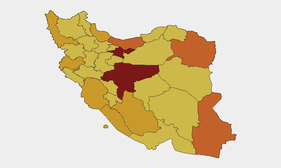
Tehran Province (risk 100) and Isfahan Province (risk 90.2) drive the composite national threat score, reflecting concentration of government, military, and critical infrastructure in the capital and central industrial belt. Eastern and southern provinces—Razavi Khorasan, Mazandaran, Sistan and Baluchestan, and Hormozgan—show elevated risk (70.9–75.9) linked to border instability, unconventional-violence activity, and maritime/smuggling networks. Northwestern frontier provinces (West Azerbaijan, Kermanshah) and southwestern energy hubs (Khuzestan, Bushehr) remain sustained high-risk zones due to cross-border militant activity and hydrocarbon strategic value. Risk concentration in Tehran and the capital's orbit suggests elevated threat to expat communities, corporate offices, and supply-chain nodes in the central corridor.
How GeoBit Would Assist
Security teams should deploy Intel Sweep and multi-language OSINT fusion to monitor Iranian state-media statements, Army/IRGC directives, and Telegram/X feeds for early signals of policy shifts or escalation. AOI (Area-of-Interest) Monitoring with alerting on Tehran, Isfahan, and maritime chokepoints (Strait of Hormuz) enables real-time notification of incidents affecting personnel or assets. Routing & Network Analysis and Maritime tracking are essential for alternative journey planning and vessel-transit risk assessment during periods of elevated drone/missile activity in the Gulf.
7-Day Outlook
Diplomatic temperature will likely remain elevated, with further public statements expected from Iranian and Western actors. Maritime risk in the Strait of Hormuz should be treated as persistent through the outlook window absent a de-escalation signal. Internal security incidents remain low-reported but are not ruled out; continued focus on border provinces (Kermanshah, Sistan and Baluchestan) and energy infrastructure monitoring is warranted.
Highest-Risk Areas — Ranked
| # | State / Region | Risk |
|---|---|---|
| 1 | Tehran Province | 100 |
| 2 | Isfahan Province | 90.2 |
| 3 | Razavi Khorasan | 75.9 |
| 4 | Mazandaran Province | 75.5 |
| 5 | Sistan and Baluchestan Province | 73 |
| 6 | Fars Province | 72.7 |
| 7 | Gilan Province | 72.3 |
| 8 | West Azerbaijan Province | 72.3 |
| 9 | Bushehr Province | 71.8 |
| 10 | Kermanshah Province | 71.7 |
| 11 | Khuzestan Province | 71.6 |
| 12 | Hormozgan Province | 70.9 |
Sources
Previous Daily Briefs
A new Iran brief is written every day — each with its own risk map and downloadable CSV. Here's the last week; use the calendar to go further back.
📅 Browse every day by calendar →
Highlighted days have a brief. Tap a day for that day's map & analysis, or “csv” for that day's dataset ($5).