Situation Summary
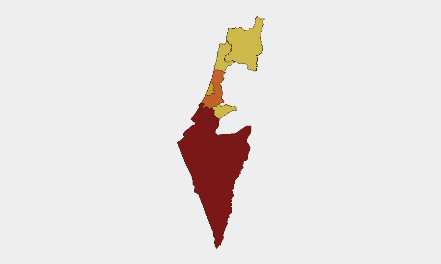
Israel remains at global threat rank #4 with an active composite threat score of 100, driven primarily by ongoing military operations. The past 24–48 hours have seen a mix of security incidents spanning armed violence, infrastructure targeting, border-control activity, and routine traffic accidents, with no single event indicating a major escalation but cumulative activity reinforcing elevated baseline risk. The South District remains the highest-risk sub-national zone (score 100), while Center, Tel Aviv, Haifa, North, and Jerusalem districts all register elevated risk (70–73.8), reflecting distributed rather than concentrated threat.
Key Developments
- Tel Aviv grenade attack (July 14): A hand grenade was thrown on Mahal Street, resulting in light injury to one person. This represents a rare direct-action incident in a major urban center and reflects localized instability.
- Herzliya restaurant shooting (July 14): The *Japanica* restaurant sustained gunfire overnight with bullet strikes to the front window; no injuries reported. Indicates armed criminal or conflict-related activity in a coastal urban zone.
- Jerusalem light-rail construction fire (July 14): Police are investigating a suspicious fire at the city's light-rail construction site. Infrastructure targeting has been a recurrent pattern; if intentional, this represents a strategic disruption vector.
- Northern border detention (July 14, Kiryat Shmona area): Israeli police detained one adult and four minors attempting to cross into Lebanon near the Hatzbani River. Reflects ongoing border tension and possible human-trafficking or ideological-crossing attempts.
- Armed assault in Sulam (July 14): A 74-year-old woman was attacked with weapons in the Arab village of Sulam, east of Afula. Indicates localized violent crime or sectarian incident in the North District.
- Multiple serious traffic incidents (July 14): A motorcyclist critically injured in a bus collision (Rosh HaAyin), a pedestrian seriously struck by bus (Nesher), and a fatal car crash in the Negev. While routine accidents, they compound emergency-response burden and highlight transport-corridor vulnerability.
- Kidnapping arrests in Yavne (July 14): Police arrested five residents suspected of involvement in a man's kidnapping, indicating serious organized crime activity in the Center District.
- IDF drill notification (July 15, Kiryat Shmona): Municipality announced an IDF exercise beginning 5 p.m. with expected explosions. This is official training activity but may generate civilian confusion or false-alarm reports.
Highest-Risk Areas
The South District's rank-100 score reflects its proximity to active conflict zones and sustained military operations. The Center, Tel Aviv, and Haifa districts (72.5–73.8) are being driven by documented urban violence incidents (grenade, shooting) and serious crime (kidnapping, armed assault), indicating that threat is no longer confined to periphery but penetrating major population centers. The North and Jerusalem districts (70–70.7) remain elevated due to border volatility, infrastructure vulnerability, and localized sectarian tension. Collectively, risk is distributed across all major urban and northern zones, not isolated to a single geography.
How GeoBit Would Assist
Security teams should deploy AOI Monitoring & Early Warning on South District, Tel Aviv, and Haifa to detect emerging patterns in armed violence and crime clustering. Intel Sweep and multi-language OSINT fusion across X, Telegram, and local Hebrew-language sources will surface real-time incident reports and intent signals ahead of mainstream news. Routing & Network Analysis should model alternative transport corridors around known conflict and crime hotspots, and GIS & Spatial Analysis will correlate infrastructure targeting (construction sites, transport nodes) with attacker motivation and capability.
7-Day Outlook
Barring a major escalation in military operations, security risk is likely to remain at current elevated baseline with continued distributed incidents in urban and northern zones. Watch for clustering of armed violence in Tel Aviv and Center District, potential escalation in border-crossing attempts, and any targeting of critical infrastructure. IDF exercises and routine drills may generate periodic false-alarm signals; correlation with official municipal advisories will clarify intent.
Highest-Risk Areas — Ranked
| # | State / Region | Risk |
|---|---|---|
| 1 | South District | 100 |
| 2 | Center District | 73.8 |
| 3 | Tel-Aviv District | 72.5 |
| 4 | Haifa District | 70.8 |
| 5 | North District | 70.7 |
| 6 | Jerusalem District | 70 |
Sources
Previous Daily Briefs
A new Israel brief is written every day — each with its own risk map and downloadable CSV. Here's the last week; use the calendar to go further back.
📅 Browse every day by calendar →
Highlighted days have a brief. Tap a day for that day's map & analysis, or “csv” for that day's dataset ($5).
Atlas — our AI intelligence desk — emails them this snapshot personally. Nothing else, no list.