Situation Summary
Lebanon faces acute and escalating cross-border military pressure, with Israeli forces conducting concentrated airstrikes, artillery barrages, and controlled demolitions across southern governorates over the past 48 hours. Multiple simultaneous incidents in Nabatieh and Bint Jbeil districts—including machine-gun fire on civilian areas, residential demolitions, and drone operations—indicate a coordinated campaign rather than isolated clashes. The broader regional context includes U.S.–Iran military signaling and Lebanese military statements on 18 July, suggesting potential for rapid escalation beyond current kinetic activity. Organizations with personnel or assets in the South, Beqaa, or southern Beirut suburbs face immediate protective and evacuation planning requirements.
Key Developments
- Harees, Bint Jbeil (night 16 Jul): Israeli forces conducted machine-gun fire on residential areas, trapping civilians who requested Lebanese Army evacuation support.
- Majdel Zoun & Haddatha, Tyre district (morning 17 Jul): Israeli forces demolished multiple residential structures in controlled demolition operations in both villages.
- Kfar Tebnit & Safita, Nabatieh governorate (17 Jul): Two explosions reported within <2 hours following Israeli strikes; Safita blast occurred on southern outskirts of Yahmar al-Shqif.
- Bayut al-Siyad, South Lebanon (17 Jul): Israeli artillery shelling recorded as part of same-day cluster of strikes.
- Regional drone activity (16–17 Jul): Overflights reported over Beirut southern suburbs concurrent with southern bombardment surge.
- Military & diplomatic signaling (17–18 Jul): U.S.–Iran military event signals and Lebanese military public statements issued; context suggests potential broader escalation.
Highest-Risk Areas
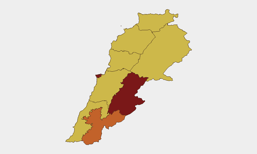
Beqaa and South governorates dominate the current risk profile. Beqaa Governorate (composite risk 100) and the three southern regions—Nabatieh (75.7), South (70), and Baalbek-Hermel (70)—are experiencing or are immediately adjacent to active Israeli military operations. Concentrated demolition and bombardment activity in Nabatieh and Bint Jbeil over 16–17 July reflects a shift toward sustained kinetic operations in populated border areas rather than sporadic exchanges. Beirut Governorate (84.7), though not directly under bombardment, remains at elevated risk owing to drone overflights, potential for secondary effects, and its role as a political and economic hub where escalation decisions are made and where large expatriate and multinational populations are concentrated.
How GeoBit Would Assist
AOI Monitoring & Early Warning on Beqaa, Nabatieh, and southern Beirut districts would provide persistent real-time alert feeds on military activity, civilian movement, and infrastructure damage, enabling rapid duty-of-care notifications. Battle mapping and conflict intelligence, combined with alternative route planning and network analysis, would help security teams identify safe corridors and evacuation routes around active bombardment zones. Multi-language OSINT (X/Telegram, news aggregation, radio SIGINT) and sentiment & temporal analysis would track Lebanese military posture, Hezbollah messaging, and regional actor statements to flag imminent escalation or de-escalation signals before kinetic events occur.
7-Day Outlook
Israeli operations in the South show signs of intensification rather than deescalation; three separate demolition sites and multiple simultaneous explosions within 24 hours suggest a sustained campaign. Lebanese military and Iranian statements on 17–18 July indicate rising political pressure for response, and U.S.–Iran military signaling raises the risk of regional-level escalation that could widen the Lebanese theater. Organizations should assume current operational tempo in the South will persist and prepare contingency evacuation and shelter-in-place protocols for 7–14 days.
Highest-Risk Areas — Ranked
| # | State / Region | Risk |
|---|---|---|
| 1 | Beqaa Governorate | 100 |
| 2 | Beirut Governorate | 84.7 |
| 3 | Nabatieh Governorate | 75.7 |
| 4 | Mount Lebanon Governorate | 70.5 |
| 5 | Keserwan-Jbeil Governorate | 70.3 |
| 6 | North Governorate | 70 |
| 7 | Akkar Governorate | 70 |
| 8 | South Governorate | 70 |
| 9 | Baalbek-Hermel Governorate | 70 |
Sources
Previous Daily Briefs
A new Lebanon brief is written every day — each with its own risk map and downloadable CSV. Here's the last week; use the calendar to go further back.
📅 Browse every day by calendar →
Highlighted days have a brief. Tap a day for that day's map & analysis, or “csv” for that day's dataset ($5).
Atlas — our AI intelligence desk — emails them this snapshot personally. Nothing else, no list.