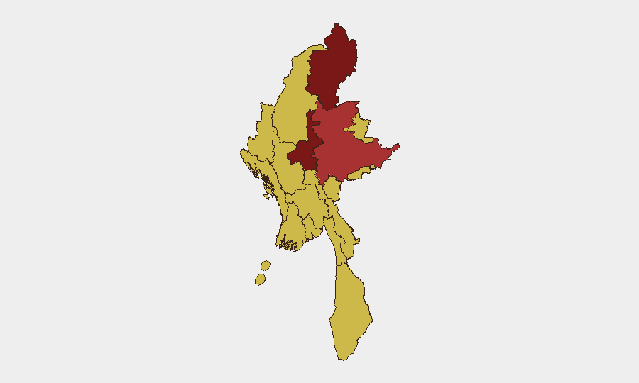
Situation Summary
Myanmar remains in active armed conflict spanning central, northern, and eastern regions, with junta forces conducting sustained military operations against multiple resistance forces and armed ethnic organizations. Nationwide conflict deaths have exceeded 100,000 as of late June 2026, placing Myanmar among the world's most destabilized states. Security conditions are deteriorating across urban and rural areas, with heightened checkpoint activity, detention sweeps, and sporadic armed clashes reported in Yangon, Mandalay, Kachin, and Sagaing. The trajectory indicates sustained or intensifying operational tempo without near-term political resolution.
Key Developments
- Yangon Region, 1–2 July 2026: Heightened security sweeps, checkpoints, and night-time raids conducted by junta forces in Hlaing Tharyar and North Dagon townships. Arbitrary detentions reported in response to suspected resistance activity.
- Central Myanmar (Magway, Sagaing, Mandalay), 30 June–early July 2026: Intensive junta airstrikes and artillery shelling ongoing across central interior regions. Village roads and access routes disrupted; some settlements destroyed or isolated within the past 48 hours from latest reporting.
- Kachin State, late June 2026: Sustained armed clashes and ambushes reported; state remains highest-risk sub-national zone (risk score 100).
- Mandalay Region, late June 2026: Ongoing urban and peri-urban security operations with sporadic armed clashes; secondary-highest risk concentration (risk score 82.7).
- National conflict toll: ACLED data confirms cumulative death toll reached approximately 100,114 fatalities as of late June 2026, reflecting sustained casualty rates across multiple theaters.
Highest-Risk Areas
Kachin State and Mandalay Region drive the highest threat concentrations, reflecting active armed engagement between junta and non-state armed organizations (primarily the Kachin Independence Army in the north). Sagaing and Shan States follow, with sustained military operations and contested territorial control creating ongoing risk to movement and civilian presence. Yangon, despite lower absolute conflict intensity, faces elevated urban security risk due to heightened junta checkpoint activity, detention operations, and counter-insurgency sweeps—making it operationally risky for corporate or humanitarian personnel despite its economic importance. Tanintharyi, Chin, Wa State, and remaining regions show uniform elevated risk (70 composite), indicating nationwide penetration of instability.
How GeoBit Would Assist
Corporate security and duty-of-care teams would use AOI (Area-of-Interest) Monitoring & Early Warning to receive persistent alerts on military operations, checkpoint activity, and conflict movement in specific townships or provinces where personnel or assets are located. Conflict & Military battle mapping and force-structure tracking enable real-time understanding of which armed actors control or contest specific roads, supply lines, and urban zones—critical for alternative routing and movement planning. OSINT fusion (X/Twitter, Telegram, local-language feeds, YouTube conflict documentation) combined with temporal and sentiment analysis provides ground-truth corroboration of junta or resistance claims and identifies emerging hotspots before mainstream reporting.
7-Day Outlook
Junta airstrikes and ground operations in central and northern regions are expected to continue at current or elevated tempo, with Kachin and Mandalay remaining focal points. Yangon security sweeps will likely persist as the junta sustains counter-resistance operations in urban areas. No ceasefire negotiations or political breakthrough indicators are evident; risk of escalation or geographic expansion remains elevated.
Highest-Risk Areas — Ranked
| # | State / Region | Risk |
|---|---|---|
| 1 | Kachin State | 100 |
| 2 | Mandalay | 82.7 |
| 3 | Shan State | 78 |
| 4 | Sagaing Region | 70.7 |
| 5 | Yangon | 70.4 |
| 6 | Tanintharyi Region | 70 |
| 7 | Chin | 70 |
| 8 | Wa State (Northern Region) | 70 |
| 9 | Magway | 70 |
| 10 | Rakhine | 70 |
| 11 | Ayeyarwady | 70 |
| 12 | Naypyitaw Union Territory | 70 |
Sources
Previous Daily Briefs
A new Myanmar brief is written every day — each with its own risk map and downloadable CSV. Here's the last week; use the calendar to go further back.
📅 Browse every day by calendar →
Highlighted days have a brief. Tap a day for that day's map & analysis, or “csv” for that day's dataset ($5).