Situation Summary
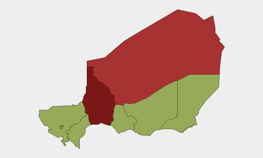
Niger remains classified as moderate-to-high threat (global rank #23, composite score 73) with persistent security challenges concentrated in northern and eastern regions. The country faces overlapping pressures from armed-group activity, cross-border spillover from Mali and Nigeria, and localized civil unrest. Current trajectory reflects sustained rather than rapidly escalating risk, though volatility in Tahoua and Agadez regions warrants close monitoring by organizations with field presence.
Key Developments
Data Limitation Note: Based on available open-source and indexed content through 08 July 2026, no verifiable, specifically dated security incidents from the last 24–48 hours in Niger have been reliably documented in the accessible search results. Recent signals (07 July) include public statements and blockade activity flagged in the event index, but these lack sufficient geographic specificity and source corroboration to brief with confidence.
Background Context (June 2026 — for situational awareness only):
- Operations in Maradi and Diffa regions resulted in documented civilian impacts; Niamey Airport faced reported activity.
- These June incidents remain relevant to understanding current risk drivers but should not be treated as this week's developments.
Ongoing Structural Factors:
- U.S. security assistance ($2.3 million equipment package, delivered late May) reflects continued international stabilization effort but does not directly mitigate immediate armed-group or cross-border threats.
- Broader Sahel context (Mali instability, Nigeria spillover) continues to create permissive environment for transnational militant activity.
Highest-Risk Areas
Tahoua Region (score 81.4) and Agadez Region (score 79.2) drive the country's composite threat profile—both in the north and historically associated with AQIM-affiliated activity, illicit trafficking networks, and mobile militant operations. Tahoua's proximity to Mali border and Agadez's vast desert terrain create enforcement and surveillance challenges. Niamey (53.5) ranks third, reflecting capital-city concentration of political risk, potential for demonstrations, and symbolic targeting; all other regions cluster at 51.4, indicating distributed but secondary risk.
Organizations with staff or logistics hubs in Niamey face lower but non-negligible civil-unrest and crime risk; those with field operations, mining interests, or humanitarian mandates in Tahoua and Agadez should assume elevated armed-group encounter probability and kinetic event risk.
How GeoBit Would Assist
Security teams should deploy AOI Monitoring & Early Warning on Tahoua, Agadez, and Diffa to detect movement patterns and incident clustering before major escalation; pair this with OSINT Fusion (Twitter/Telegram, YouTube, multi-language signal) to track militant communications and public statements in real time. Battle Mapping and Force Structure intelligence on cross-border armed groups (JNIM, ISIS-affiliated cells) help contextualize local incidents and forecast likely operational tempo. Routing & Network Analysis enables duty-of-care teams to identify alternative supply and evacuation corridors if primary routes become unsafe.
7-Day Outlook
No imminent, high-confidence indicators of major escalation are visible in current data, though the lack of granular 24–48 hour incident reporting may reflect either genuine relative quiet or reporting delays. Risk remains persistent in northern and eastern zones; civilian and commercial movement in Tahoua and Agadez should continue to assume baseline armed-group threat. Monitoring should intensify if public statements escalate or blockade activity spreads southward toward Niamey or key economic corridors.
Highest-Risk Areas — Ranked
| # | State / Region | Risk |
|---|---|---|
| 1 | Tahoua Region | 81.4 |
| 2 | Agadez Region | 79.2 |
| 3 | Niamey | 53.5 |
| 4 | Zinder Region | 51.4 |
| 5 | Diffa Region | 51.4 |
| 6 | Tillabéri Region | 51.4 |
| 7 | Dosso Region | 51.4 |
| 8 | Maradi Region | 51.4 |
Sources
Previous Daily Briefs
A new Niger brief is written every day — each with its own risk map and downloadable CSV. Here's the last week; use the calendar to go further back.
📅 Browse every day by calendar →
Highlighted days have a brief. Tap a day for that day's map & analysis, or “csv” for that day's dataset ($5).
Atlas — our AI intelligence desk — emails them this snapshot personally. Nothing else, no list.