Situation Summary
Nigeria remains Africa's most populous nation and a critical economic hub, but faces compounding security and environmental shocks that are elevating risk across multiple states. Insurgency in the north continues to drive the global threat ranking (#13 worldwide, composite score 90), while banditry, kidnapping, and organized crime persist across central and southern corridors. The catastrophic Mokwa flooding event (151+ confirmed dead, ~700 feared) has compounded mobility and humanitarian challenges in Niger State, while misinformation on social media is amplifying perceived crisis severity and complicating situational awareness for on-ground teams.
Key Developments
- Mokwa, Niger State (5 July): Torrential rains triggered flash flooding with at least 151 confirmed deaths and approximately 500 missing; search-and-recovery operations ongoing, with critical infrastructure (roads, facilities) damaged and widespread displacement reported.
- Mokwa corridor, Niger State (5–7 July): Flood-related damage to transportation networks and local infrastructure continues to impair movement and emergency response capability in the central Niger State corridor.
- Katsina State highway (4 July): Armed bandits abducted nine travellers on an inter-state route, consistent with ongoing kidnap-for-ransom targeting overland traffic in the north.
- Edo State (4 July): Police mass-arrest operation detained 45 suspects and rescued 38 abducted victims, demonstrating scale of criminal networks and active state counter-kidnapping capability.
- Kwara State forest area (4 July): Security forces foiled a kidnap plot and rescued a woman and two-year-old child from a rural location, reinforcing rural abduction risk.
- Kogi State livestock corridor (early 5 July): Security forces recovered approximately 1,000 rustled livestock during an anti-bandit operation, indicating persistent organized rustling and concurrent tactical response.
- Nigeria-wide social media environment (6–7 July): X, WhatsApp, and other platforms amplifying unverified claims of coordinated attacks; police debunked viral Lagos incident claims as motorcycle theft and homicide, underscoring information-risk and need for multi-source verification.
Highest-Risk Areas
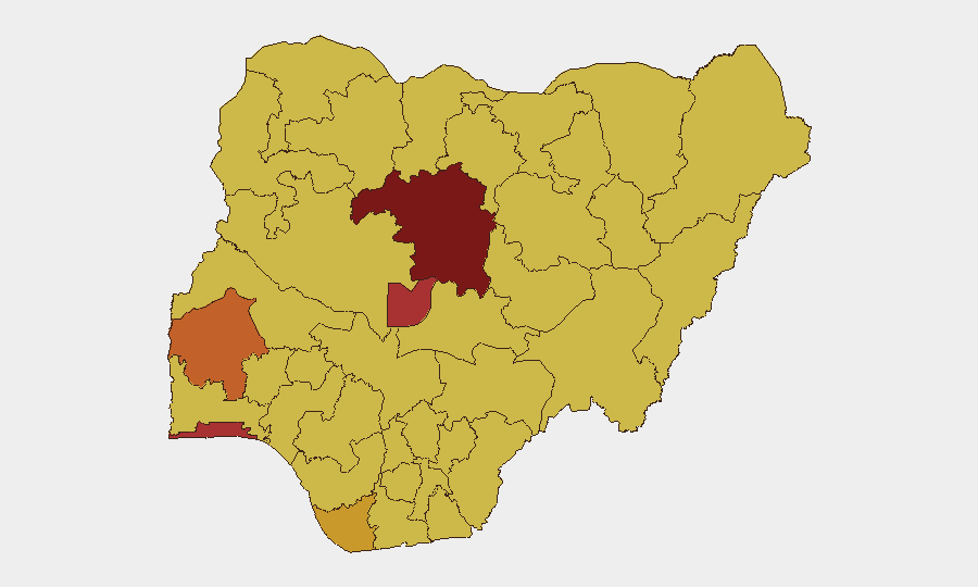
Kaduna State remains the single highest-risk zone (93.1 composite score), driven by persistent insurgency and bandit activity affecting both urban and rural corridors. The Federal Capital Territory (78.5) and Lagos State (76.2) follow, reflecting threats from kidnapping, organized crime, and social instability in Nigeria's economic and political centers. The top 12 risk-ranked states collectively account for the majority of tracked events; northern and central states (Kaduna, Kano, Taraba, Kogi) are dominated by insurgency and banditry, while southern and coastal zones (Lagos, Rivers, Bayelsa) are driven by kidnapping, cultism, and resource-related tension. Recent flooding in Niger State (not currently in the top 12 but historically volatile) has temporarily elevated immediate humanitarian and mobility risk.
How GeoBit Would Assist
Organizations with personnel or assets in Nigeria should deploy AOI Monitoring & Early Warning on Kaduna, FCT, and Lagos for real-time event alerting; use Routing & Network Analysis to identify secure alternative transport corridors and avoid bandit-active highways; and activate Intel Sweep and X/Twitter OSINT to distinguish credible security incidents from viral misinformation before triggering evacuation or lockdown decisions. Satellite & Imagery analysis can track flooding extent and infrastructure damage in Niger State and assess route passability, while Conflict & Military mapping provides updated force positioning and state security-operation status in high-risk northern states.
7-Day Outlook
Flood-related displacement and infrastructure damage in central Nigeria will persist through the week, likely complicating travel and supply-chain routes in Niger State. Banditry and kidnapping activity across northern and central corridors is expected to remain steady; the rainy season typically correlates with increased criminal mobility in rural areas. Social media-driven false alarms are likely to recur, requiring heightened internal verification discipline among duty-of-care and security teams.
Highest-Risk Areas — Ranked
| # | State / Region | Risk |
|---|---|---|
| 1 | Kaduna State | 93.1 |
| 2 | Federal Capital Territory | 78.5 |
| 3 | Lagos State | 76.2 |
| 4 | Oyo State | 75.7 |
| 5 | Bayelsa State | 72 |
| 6 | Rivers State | 69.3 |
| 7 | Cross River State | 67.6 |
| 8 | Kano State | 66.4 |
| 9 | Ogun State | 66.4 |
| 10 | Taraba State | 65.8 |
| 11 | Abia State | 65.4 |
| 12 | Kogi State | 64.7 |
Sources
Previous Daily Briefs
A new Nigeria brief is written every day — each with its own risk map and downloadable CSV. Here's the last week; use the calendar to go further back.
📅 Browse every day by calendar →
Highlighted days have a brief. Tap a day for that day's map & analysis, or “csv” for that day's dataset ($5).
Atlas — our AI intelligence desk — emails them this snapshot personally. Nothing else, no list.