Situation Summary
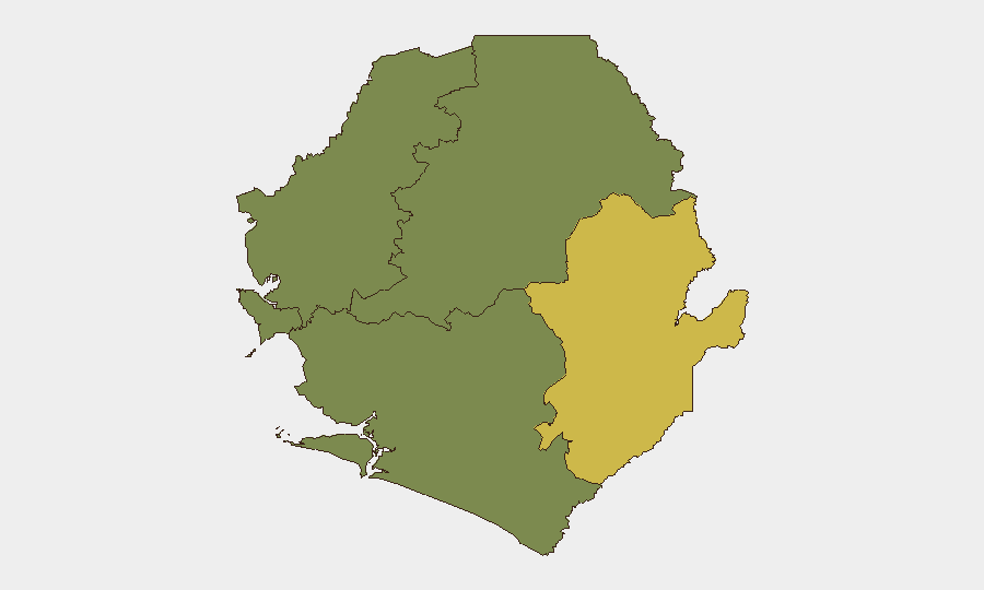
Sierra Leone remains a low-frequency, moderate-baseline-risk environment globally (#89 composite threat score) with no verified security incidents in the last 24–48 hours. The country's threat landscape is concentrated in the Eastern Province (composite risk 68), driven by ongoing violent crime and intercommunal tensions, while the Western Area (risk 35) presents secondary urban crime and political volatility. Overall security conditions are stable relative to the region, but persistent underlying risks—larceny, fraud, civil unrest potential, and northern border sensitivities—warrant continued monitoring for corporate and expatriate populations.
Key Developments
No verified incident-level security, conflict, crime, or infrastructure events have been confirmed in Sierra Leone within the last 24–48 hours according to open-source reporting, social media, and news feeds. Web and OSINT sources do not surface time-stamped reports of protests, clashes, criminal attacks, or infrastructure failures dated 25–26 July 2026.
The most recent clearly dated regional development is the 19 July 2026 ECOWAS 69th Ordinary Session communiqué (Lungi, Sierra Leone), in which the regional body urged Guinea to fully withdraw troops from the Yenga and Lofa border enclaves. This represents ongoing diplomatic pressure rather than a confirmed troop movement or fresh conflict incident and falls outside the 48-hour window.
Port Loko District (Northern Province) continues to experience larceny and fraud as dominant crime types, with multiple cases under investigation by the Port Loko Police Division Crime Office. No specific incident dates within the last 48 hours are confirmed in available reports.
Highest-Risk Areas
Eastern Province dominates the sub-national ranking (risk 68), reflecting sustained violent crime, armed robbery, and intercommunal conflict—factors that persist despite the absence of reportable incident activity in the last two days. The Western Area (risk 35), which includes Freetown and immediate surroundings, contributes secondary urban crime risk and political sensitivity tied to the capital's population density and administrative concentration. Northern and Southern Provinces register minimal tracked risk (0), though this reflects detection limitations rather than absence of crime or community tensions. Corporate and duty-of-care teams should weight Eastern Province and Freetown as primary operational risk zones.
How GeoBit Would Assist
Security teams would use AOI (Area-of-Interest) Monitoring & Early Warning on Eastern Province, Freetown, and the Yenga/Lofa border to detect emerging protest activity, criminal incidents, or political developments in real time. Intel Sweep, X/Twitter OSINT, and multi-language search capabilities enable continuous monitoring for indicators of unrest, trafficking, or intercommunal violence that precede larger events. Risk & Threat Assessment and Sentiment & Temporal Analysis tools would flag shifts in political or criminal activity patterns before they mature into incidents affecting personnel or assets.
7-Day Outlook
No major security escalation is anticipated in the next week. Conditions in Eastern Province and Freetown are expected to remain consistent with baseline crime and low-level civil unrest; diplomatic pressure on Guinea regarding border enclaves will likely continue without military escalation. Routine vigilance on larceny, fraud, and robbery in urban and provincial centers remains appropriate for all corporate operations.
Highest-Risk Areas — Ranked
| # | State / Region | Risk |
|---|---|---|
| 1 | Eastern Province | 68 |
| 2 | Western Area | 35 |
| 3 | North West Province, Sierra Leone | 0 |
| 4 | Northern Province, Sierra Leone | 0 |
| 5 | Southern Province, Sierra Leone | 0 |
Sources
Previous Daily Briefs
A new Sierra Leone brief is written every day — each with its own risk map and downloadable CSV. Here's the last week; use the calendar to go further back.
📅 Browse every day by calendar →
Highlighted days have a brief. Tap a day for that day's map & analysis, or “csv” for that day's dataset ($5).
Atlas — our AI intelligence desk — emails them this snapshot personally. Nothing else, no list.