Situation Summary
Sudan remains in active civil war between the Sudanese Armed Forces (SAF) and the Rapid Support Forces (RSF), with the conflict now in its third year and showing intensification rather than de-escalation. The composite threat score of 100 places Sudan as the 7th highest-risk country globally; 78 tracked events in the past reporting cycle reflect sustained conventional military operations, drone strikes, atrocity documentation, and humanitarian collapse. North Kordofan State—particularly the city of El Obeid—has emerged as a critical flashpoint in the past 48 hours, with escalating aerial and artillery attacks on civilian infrastructure and ongoing encirclement by RSF forces.
Key Developments
- El Obeid, North Kordofan – 10–11 July 2026: Drone strikes over the past 24 hours targeted fuel stations, power supply, water infrastructure, and five oil tank farms in rapid succession, disrupting essential services and forcing civilian displacement from the city.
- El Obeid intensification – 9–11 July 2026: UN Fact-Finding Mission released a report (published 10 July) documenting genocide-level crimes in prior RSF operations and warning of imminent atrocities in currently contested areas, specifically El Obeid, where RSF encirclement and escalating attacks are ongoing.
- Casualties in El Obeid – past days: Multiple humanitarian and local sources report dozens killed in recent weeks, with confirmed casualties continuing over the last 24–72 hours as drone and artillery strikes hit residential areas and supply routes.
- Humanitarian access degradation – 10–11 July 2026: Attacks on aid workers and supply corridors in the past 48 hours are further obstructing delivery to Khartoum, El Fasher, and El Obeid; famine conditions are spreading as blockades persist.
- Iran–Sudan military activity – 12 July 2026: Intelligence signals recorded on 12 July reflect conventional military force interactions between Iran and Sudan; context and scale remain under assessment.
- Diplomatic detention – 12 July 2026: An envoy was arrested or detained on 12 July; circumstances and nationality are unclear but indicate ongoing political volatility and external engagement.
- Border spillover toward Egypt – 10–11 July 2026: Renewed fighting in northern Sudan and greater Khartoum in recent days is driving additional displacement toward Egyptian borders, compounding refugee flows exceeding one million and raising near-term cross-border security risks.
Highest-Risk Areas
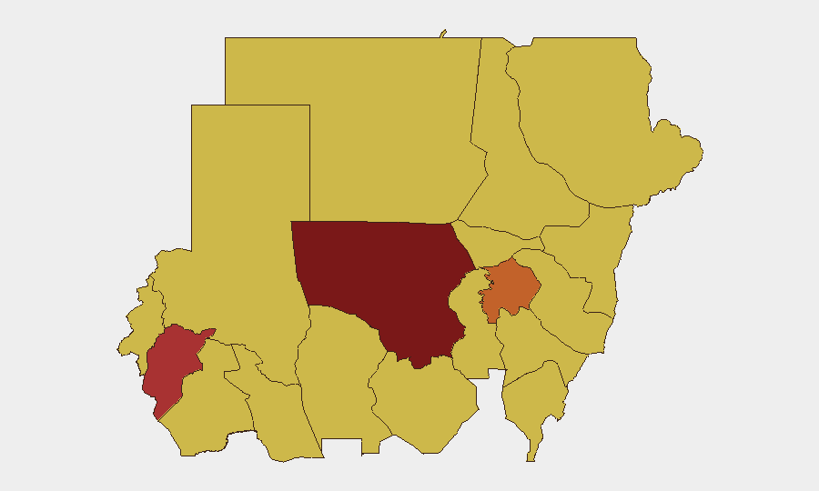
North Kordofan State dominates the immediate threat landscape (risk score 100), driven by the active military contest for El Obeid and recent drone strikes on critical civilian infrastructure. Central Darfur (77.6), Aj Jazira (75.6), and Al Khartum (70.4) follow; these areas combine active RSF operations, SAF defensive positions, and documented atrocity patterns. The clustering of risk scores at 70 across Blue Nile, River Nile, Red Sea, Al Qadarif, Kassala, Sennar, and South Darfur reflects the conflict's geographic spread and the widespread breakdown of state authority, making any travel or asset presence across these zones high-risk.
How GeoBit Would Assist
Security teams should activate Area-of-Interest Monitoring & Early Warning for North Kordofan, Al Khartum, and Central Darfur to detect tactical shifts, drone activity patterns, and displacement surges in near-real time. Satellite & Imagery Analysis combined with GIS & Spatial Analysis provides damage assessment of critical infrastructure and route viability for supply chains or evacuation planning. Conflict & Military capabilities—including force-structure tracking and battle-mapping—enable precise understanding of SAF and RSF positioning, while OSINT Fusion across social media, humanitarian feeds, and diplomatic channels contextualizes atrocity warnings and access constraints for duty-of-care compliance.
7-Day Outlook
Intensification in El Obeid and surrounding North Kordofan is expected to continue, with further infrastructure targeting and civilian pressure likely in the next 7 days. Humanitarian access will remain severely constrained, raising acute risk for international staff and supply operations. Border instability and Egypt-ward displacement may accelerate if SAF–RSF competition for northern positions intensifies.
Highest-Risk Areas — Ranked
| # | State / Region | Risk |
|---|---|---|
| 1 | North Kordofan State | 100 |
| 2 | Central Darfur State | 77.6 |
| 3 | Aj Jazira | 75.6 |
| 4 | Al Khartum | 70.4 |
| 5 | South Kordofan | 70.4 |
| 6 | Blue Nile | 70 |
| 7 | River Nile State | 70 |
| 8 | Red Sea State | 70 |
| 9 | Al Qadarif State | 70 |
| 10 | Kassala State | 70 |
| 11 | Sennar State | 70 |
| 12 | South Darfur State | 70 |
Sources
Previous Daily Briefs
A new Sudan brief is written every day — each with its own risk map and downloadable CSV. Here's the last week; use the calendar to go further back.
📅 Browse every day by calendar →
Highlighted days have a brief. Tap a day for that day's map & analysis, or “csv” for that day's dataset ($5).
Atlas — our AI intelligence desk — emails them this snapshot personally. Nothing else, no list.