Situation Summary
Suriname remains a low-intensity threat environment with no confirmed large-scale civil unrest, protests, or political instability events in the last 24–48 hours. Composite threat score of 4 and absence of tracked discrete security incidents in the current window reflect an overall stable operating climate. However, localized criminal activity—particularly in interior and northwestern districts—continues to generate risk for personnel and assets, with recent incidents involving hazardous-materials trafficking, armed robbery, and in-custody mortality raising duty-of-care concerns.
Key Developments
- Burnside checkpoint, Coronie District – 25 Aug 2026: Police intercepted more than 2 tons of suspected cyanide in two trucks being transported illegally from Guyana. Multiple individuals detained for questioning; authorities investigating quantity, origin, destination, and permit status. Indicates ongoing cross-border smuggling of hazardous chemicals into Suriname's northwestern corridor.
- Police Bureau Centrum, Paramaribo – 23–25 Aug 2026: A detainee died in custody at the central police station around 18:50 on 23 Aug; police report no visible signs of violence. Investigation underway into cause of death and circumstances; identity not yet released. Raises transparency and detention-condition concerns relevant to staff welfare protocols.
- De Goede Verwachting, Wanica District – 25 Aug 2026: Armed home invasion resulted in injury to a resident; at least one armed suspect involved in robbery. Reflects continued street crime and residential-security risk in populated coastal regions.
- No escalation to national unrest: Regional monitoring confirms absence of multi-sourced security events meeting large-scale incident criteria in the last 24–48 hours, with threat environment characterized as low-intensity and localized.
Highest-Risk Areas
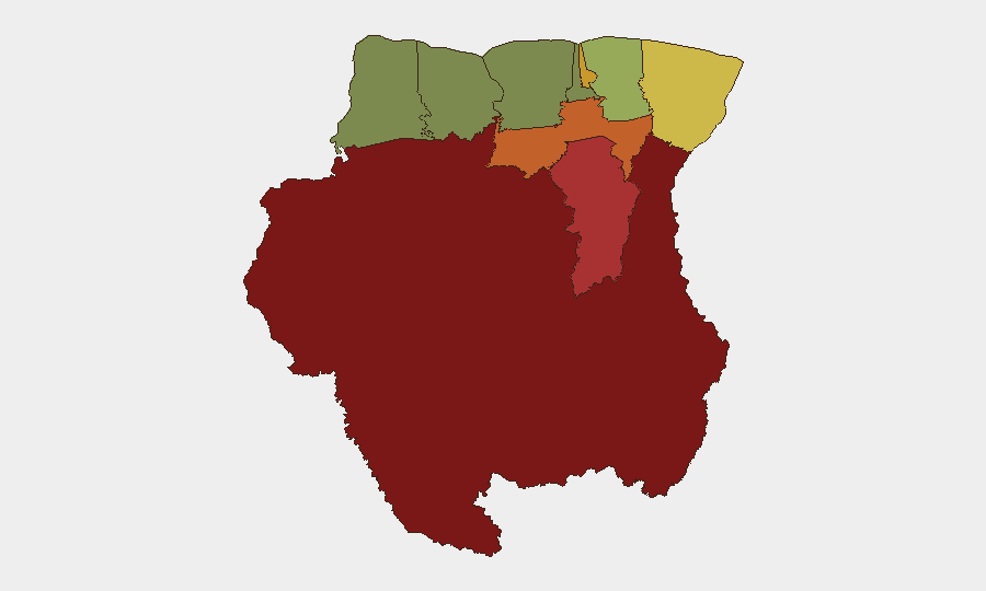
Interior and western districts dominate the risk profile. Sipaliwini (risk 92) and Brokopondo (risk 78)—both remote, sparsely populated zones—carry the highest composite scores, driven by limited state presence, informal mining activity, and cross-border smuggling networks. Para (risk 74) and Paramaribo (risk 71) reflect urban crime concentration and transit corridors for illicit goods. Marowijne (risk 68) on the eastern border with French Guiana presents ongoing contraband and irregular-migration pressures. Coastal districts (Commewijne, Wanica) register moderate risk from street crime and robbery. Northern and western rural zones (Coronie, Nickerie) show lower scores but remain entry/exit points for trafficking. For corporate operations, Paramaribo and Commewijne present the highest day-to-day people-safety exposure; supply-chain and asset routes through Sipaliwini and Para require smuggling and theft mitigation.
How GeoBit Would Assist
Security teams in Suriname should deploy AOI Monitoring & Early Warning on high-risk districts (Sipaliwini, Brokopondo, Paramaribo, Marowijne) to detect escalation in crime, trafficking, or unrest with persistent alerting. OSINT fusion—incorporating X/Twitter, local news, and police bulletins in Dutch—provides real-time visibility into street-level incidents, detainee issues, and trafficking patterns missed by formal reporting. Routing & Network Analysis can model safe corridors and alternative supply-chain paths to avoid known smuggling hotspots and crime zones. Entity extraction and actor mapping track criminal networks and trafficking routes for risk contextualization.
7-Day Outlook
No imminent escalation to nationwide unrest is expected in the next seven days based on current indicators and political-stability data. Localized crime and cross-border smuggling will likely continue at baseline levels, with particular risk around interior mining regions and northern checkpoints. Security teams should maintain elevated alertness for armed robbery in Paramaribo and Wanica, and monitor detention-facility developments following the in-custody death at Police Bureau Centrum.
Highest-Risk Areas — Ranked
| # | State / Region | Risk |
|---|---|---|
| 1 | Sipaliwini | 92 |
| 2 | Brokopondo | 78 |
| 3 | Para | 74 |
| 4 | Paramaribo | 71 |
| 5 | Marowijne | 68 |
| 6 | Commewijne | 42 |
| 7 | Wanica | 38 |
| 8 | Saramacca | 29 |
| 9 | Coronie | 12 |
| 10 | Nickerie | 8 |
Sources
Previous Daily Briefs
A new Suriname brief is written every day — each with its own risk map and downloadable CSV. Here's the last week; use the calendar to go further back.
- August 23, 2026
- August 20, 2026
- August 18, 2026
- August 16, 2026
- August 14, 2026
- August 12, 2026
- August 10, 2026
📅 Browse every day by calendar →
Highlighted days have a brief. Tap a day for that day's map & analysis, or “csv” for that day's dataset ($5).
Atlas — our AI intelligence desk — emails them this snapshot personally. Nothing else, no list.