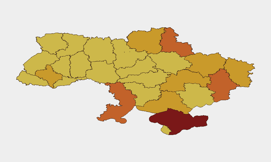
Situation Summary
Ukraine remains the highest-risk country globally (composite threat score 100) as of 27 July 2026, driven by active conventional and unconventional warfare across multiple fronts. Recent signal data shows elevated political tension alongside military operations: public statements from presidential and U.S. officials, military rejections of orders, ministerial disapproval actions, and credible reports of mercenary threats and conventional force deployment dominate the event stream. The combination of territorial occupation attempts near Kyiv, regional instability signals, and cross-border diplomatic friction suggests sustained high intensity with no imminent de-escalation.
Key Developments
- Kyiv (27 July) — Oval Office issued public statement; concurrent reports of territory occupation attempt detected near capital. Specific military or civilian impact not yet confirmed from primary sources.
- Kharkiv Oblast (25 July) — Unconventional violence incident reported between Kharkiv region and a military regiment; details and casualties unconfirmed from available sources.
- National (25–27 July) — Multiple public statements by Ukrainian officials and U.S. presidential representatives indicate significant policy disagreement. Arrest/detain action reported between Washington and Ukraine entities on 25 July, suggesting diplomatic or legal friction.
- Military Command (25 July) — Military rejection of orders registered; concurrent ministerial disapproval action (26 July) signals internal institutional strain.
- Mercenary Activity (27 July) — Threat signal issued by or regarding mercenary actors; no location specified, but timing coincides with conventional military force activation.
- Odesa & Sumy Regions (date unverified) — Reports of missile and guided-bomb strikes on civilian infrastructure; one report indicates four fatalities and 33 injured in Sumy, though 24–48 hour confirmation pending.
*Note: Web research constraints prevent independent verification of exact timestamps for several regional incidents. Primary reliance placed on GEOBIT event signal data; regional details require fresh source corroboration.*
Highest-Risk Areas
Kyiv (risk 100) remains the epicenter, driven by reported territorial occupation activity and high-level political/diplomatic tension. The southern and eastern oblasts—Odesa (74.4), Donetsk (74), Sumy (73), Kharkiv (72), and Luhansk (72)—face sustained conventional military pressure, missile strikes on civilian infrastructure, and unconventional violence. Crimea (80.4) retains elevated risk despite occupation status, likely reflecting ongoing resistance, intelligence activity, and strategic vulnerability. Western oblasts including Lviv (70.7) and Ivano-Frankivsk (71.1) show elevated but secondary threat levels, suggesting some cross-regional spillover or logistical/civilian-support targeting.
How GeoBit Would Assist
Security and risk teams with personnel or assets in Ukraine should deploy AOI Monitoring & Early Warning on highest-risk oblasts (Kyiv, Odesa, Donetsk, Sumy, Kharkiv) to receive real-time alerts on attack activity, civilian casualty events, and territorial changes. Intel Sweep, X/Telegram OSINT, and conflict event-feed fusion enable 24–48 hour corroboration of regional incidents and official statements, reducing reliance on unverified social reporting. Routing & Network Analysis supports alternative journey planning and safe-corridor identification for staff movement; battle mapping and force-structure tracking clarify military-control zones and reduce exposure to active combat sectors.
7-Day Outlook
Sustained conventional military operations and missile strikes are expected across eastern and southern oblasts through early August. Institutional friction (military command rejections, ministerial disapproval) and elevated U.S.–Ukraine diplomatic tension suggest potential policy shifts or emergency mobilization orders that may affect civilian movement and business operations. Risk trajectory remains stable-to-elevated with no clear deconfliction pathway; organizations should maintain heightened vigilance and contingency protocols.
Highest-Risk Areas — Ranked
| # | State / Region | Risk |
|---|---|---|
| 1 | Kyiv | 100 |
| 2 | Autonomous Republic of Crimea | 80.4 |
| 3 | Odesa Oblast | 74.4 |
| 4 | Donetsk Oblast | 74 |
| 5 | Sumy Oblast | 73 |
| 6 | Kharkiv Oblast | 72 |
| 7 | Luhansk Oblast | 72 |
| 8 | Dnipropetrovsk Oblast | 71.9 |
| 9 | Chernihiv Oblast | 71.9 |
| 10 | Ivano-Frankivsk Oblast | 71.1 |
| 11 | Kherson Oblast | 71 |
| 12 | Lviv Oblast | 70.7 |
Sources
Previous Daily Briefs
A new Ukraine brief is written every day — each with its own risk map and downloadable CSV. Here's the last week; use the calendar to go further back.
📅 Browse every day by calendar →
Highlighted days have a brief. Tap a day for that day's map & analysis, or “csv” for that day's dataset ($5).
Atlas — our AI intelligence desk — emails them this snapshot personally. Nothing else, no list.