Situation Summary
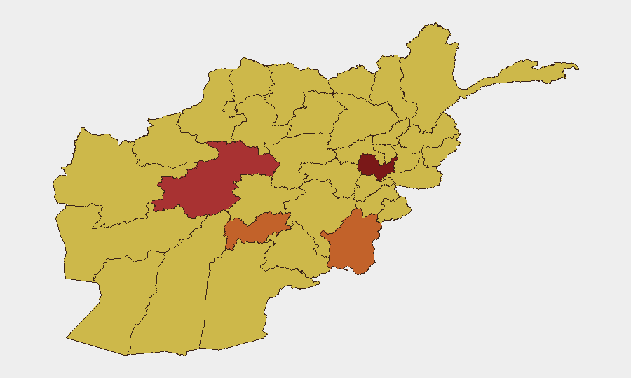
Afghanistan faces elevated near-term security risk driven by escalating cross-border military action, insurgent activity, and administrative friction with neighboring Pakistan. Kabul Province remains the highest-risk jurisdiction (93.8), though eastern frontier provinces are experiencing acute tactical volatility following Pakistani airstrikes on 4–5 July. Overall threat trajectory is rising due to border militarization, reported civilian casualty incidents, and hardening diplomatic/enforcement postures in the region.
Key Developments
- Eastern border provinces (Paktika, Paktia, Kunar) – 4–5 July 2026
Pakistani military conducted cross-border airstrikes targeting what Islamabad described as "terror infrastructure." Taliban government confirmed 38 civilian deaths and 163 injured across residential areas, signaling high-impact civilian harm in a critical frontier zone.
- Badakhshan border inspection – 5 July 2026
Taliban Defence Minister Mohammad Yaqoob Mujahid visited forward positions in Badakhshan Province to inspect deployments and meet commanders, indicating heightened military readiness and focus in the northeast corridor adjacent to Tajikistan and China.
- Renewed border exchanges – 4–5 July 2026
Regional reporting documents resumed cross-border fire and hostile exchanges between Pakistani forces and Taliban positions, described as an escalation after prior confrontations, with risk of further military engagement in coming days.
- Pakistan-wide enforcement directive (effective 10 July) – announced 4–5 July 2026
Pakistan's government ordered law enforcement nationwide to arrest Afghan citizens without valid visas beginning 10 July, creating immediate travel and migration risk for Afghans transiting between countries.
- Taliban condemnation and diplomatic escalation – 4 July 2026
Taliban spokesman Hamdullah Fitrat publicly condemned Pakistani strikes; India's Ministry of External Affairs also commented on cross-border attacks, indicating elevated regional diplomatic attention and potential for diplomatic friction affecting future stability.
- Central bank foreign-exchange auctions – 5 July 2026
Da Afghanistan Bank announced FX auctions involving commercial banks and exchange houses over the coming week, reflecting tight monetary controls and ongoing liquidity/cash-access constraints for businesses and travelers.
Highest-Risk Areas
Kabul Province (93.8) dominates the national risk profile due to insurgent targeting of government and international presence. The eastern frontier belt—Paktika, Paktia, and Kunar provinces (75.4–75.7 range)—has become acutely volatile following the 4–5 July Pakistani strikes and resulting casualty incidents; cross-border fire and Pakistani enforcement actions create overlapping kinetic and administrative hazards. A secondary cluster spanning Ghor, Uruzgan, and Zabul (63.8–77.7) faces sustained anti-government insurgency. Border-adjacent provinces carry compounded risk from both internal armed opposition and external military operations.
How GeoBit Would Assist
Area-of-Interest Monitoring & Early Warning should be configured for Kabul, eastern border provinces, and Taliban military movements to detect airstrikes, clashes, and checkpoints in near-real time. Conflict & Military capabilities enable tracking of Pakistani and Taliban force positioning, weapons, and tactical intentions to anticipate further cross-border action. Routing & Network Analysis helps security teams plan alternative travel corridors avoiding active strike zones and Pakistani enforcement operations (effective 10 July onward), while OSINT fusion across social media, regional news, and government channels maintains situational awareness of casualty updates, diplomatic statements, and rule-of-law changes.
7-Day Outlook
Cross-border tensions are likely to sustain or intensify through mid-July, with Pakistan's enforcement directive (10 July) creating secondary disruption to overland travel and commerce. Further Pakistani strikes or Taliban retaliation remain plausible given the pace of incidents and public statements. Organizations with personnel or assets in Kabul, eastern provinces, or transit routes should elevate monitoring frequency and review contingency protocols for movement restrictions and airspace/ground closures.
Highest-Risk Areas — Ranked
| # | State / Region | Risk |
|---|---|---|
| 1 | Kabul Province | 93.8 |
| 2 | Ghor Province | 77.7 |
| 3 | Paktika Province | 75.4 |
| 4 | Uruzgan Province | 75.4 |
| 5 | Zabul Province | 63.8 |
| 6 | Kandahar Province | 63.8 |
| 7 | Ghazni Province | 63.8 |
| 8 | Farah Province | 63.8 |
| 9 | Nimruz Province | 63.8 |
| 10 | Helmand Province | 63.8 |
| 11 | Jowzjan Province | 63.8 |
| 12 | Balkh Province | 63.8 |
Sources
Previous Daily Briefs
A new Afghanistan brief is written every day — each with its own risk map and downloadable CSV. Here's the last week; use the calendar to go further back.
📅 Browse every day by calendar →
Highlighted days have a brief. Tap a day for that day's map & analysis, or “csv” for that day's dataset ($5).
Atlas — our AI intelligence desk — emails them this snapshot personally. Nothing else, no list.