Situation Summary
Angola maintains baseline national stability with no armed conflict, civil unrest, critical infrastructure failures, or mass-casualty security incidents reported in the last 24–48 hours. The security environment remains characterized by localized sub-national risk, concentrated in resource-rich eastern and northeastern provinces (Cabinda, Lunda Norte/Sul, Cuando Cubango). Major urban centers, including Luanda, continue routine operations without acute incident reporting.
Key Developments
- No acute security incidents reported Angola-wide in the last 24–48 hours. Open-source monitoring, news feeds, and official channels confirm absence of armed clashes, protests with mass arrests, infrastructure disruptions, or high-impact crime events time-stamped to July 25–26, 2026.
- Wildfire activity ongoing across multiple provinces. At least 11 wildfire events have been recorded recently across Angola (event IDs 1029684, 1029687, 1029689, 1029717, 1029648, 1029646, 1029692, 1029693, 1029731, 1029718, 1029691), including one cross-border event (Angola–DRC). Specific impact on air quality, transport routes, or critical infrastructure remains under assessment.
- Angola–Bharat diplomatic statement issued (2026-07-24). Public statement recorded; context and implications for Angolan security posture or bilateral relations require clarification via official channels.
- Luanda and central zones report no mass-scale crime, riots, or new restrictions beyond routine policing operations over the assessment window.
- No cross-border conflict spillover or new terrorism alerts. Regional security monitoring indicates Angola continues to function as a regional mediator rather than conflict theater; no new alerts regarding refugee flows or armed group activity across borders.
Highest-Risk Areas
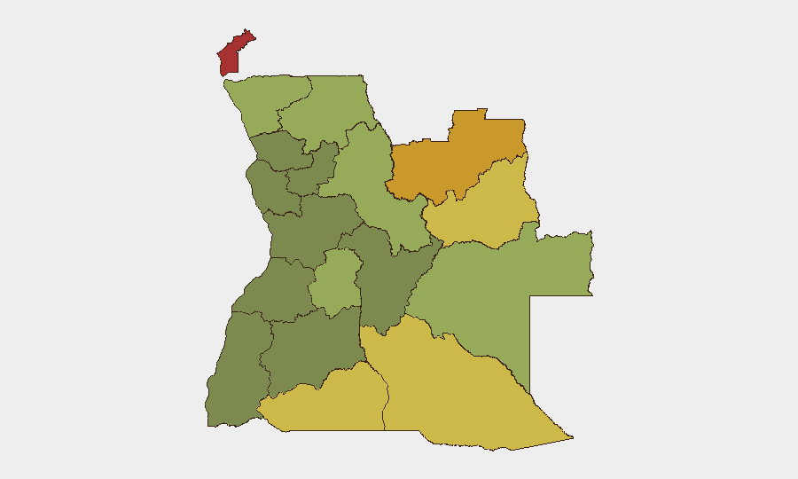
Cabinda Province (risk 78) remains the single highest-risk jurisdiction, driven by longstanding separatist tensions, oil-sector vulnerability, and historical armed-group presence; Lunda Norte (72) and Lunda Sul (68) follow, where artisanal and industrial diamond mining create competition, trafficking networks, and weak state presence. Cuando Cubango (64) and Cunene (62) extend risk into the southern border region. These five provinces account for the majority of Angola's sub-national threat profile and should be the primary focus for duty-of-care monitoring for any personnel or assets operating in resource extraction, humanitarian, or government sectors.
How GeoBit Would Assist
Intel Sweep, multi-language OSINT, and Telegram/X monitoring would enable continuous detection of armed-group communications, trafficking networks, and localized conflict signals in high-risk provinces before they escalate to national significance. AOI Monitoring & Early Warning with persistent geofencing around Cabinda, the Lundas, and major transport corridors would provide 24–48-hour advance alerting of protest mobilization, checkpoint activity, or armed movement. Conflict & Military battle mapping, entity extraction, and network analysis would track sub-national actor relationships and capability shifts relevant to expatriate or asset security posture.
7-Day Outlook
No acute escalation is anticipated over the next 7 days based on current signals. Wildfire activity and routine sub-national risk in eastern provinces will likely persist. Continued monitoring of diplomatic statements and regional spillover remains prudent given Angola's mediation role in broader southern African affairs.
Highest-Risk Areas — Ranked
| # | State / Region | Risk |
|---|---|---|
| 1 | Cabinda Province | 78 |
| 2 | Lunda Norte Province | 72 |
| 3 | Lunda Sul Province | 68 |
| 4 | Cuando Cubango Province | 64 |
| 5 | Cunene Province | 62 |
| 6 | Moxico Province | 58 |
| 7 | Zaire Province | 54 |
| 8 | Huambo Province | 50 |
| 9 | Uíge Province | 48 |
| 10 | Malanje Province | 42 |
| 11 | Bié Province | 35 |
| 12 | Huíla Province | 32 |
Sources
Previous Daily Briefs
A new Angola brief is written every day — each with its own risk map and downloadable CSV. Here's the last week; use the calendar to go further back.
📅 Browse every day by calendar →
Highlighted days have a brief. Tap a day for that day's map & analysis, or “csv” for that day's dataset ($5).
Atlas — our AI intelligence desk — emails them this snapshot personally. Nothing else, no list.