Situation Summary
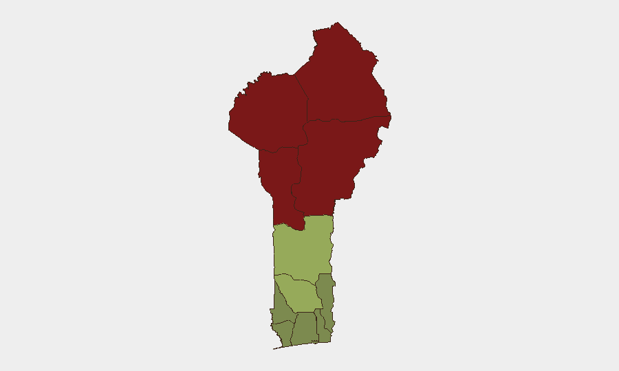
Benin remains under moderate threat pressure, ranked #54 globally, with persistent insurgency and terrorism risk concentrated in the northern border zone. No discrete security incidents have been confirmed in the past 24–48 hours; the threat environment reflects ongoing activity rather than an acute escalation. The northern departments—Alibori, Atakora, Donga, and Borgou—remain significantly elevated due to cross-border spillover from Sahel-region militant groups, while central and southern zones maintain substantially lower risk profiles.
Key Developments
No confirmed discrete events in Benin from the last 24–48 hours were identifiable in current reporting. The security landscape reflects standing conditions rather than new incident-level activity:
- Northern border terrorism remains endemic (standing threat, not new event): Alibori, Atakora, Donga, and Borgou departments continue to experience periodic militant incursions and intercommunal tensions linked to regional jihadist networks; no specific location or date-stamped incident emerged in the last two days.
- Counterterrorism cooperation with Nigeria ongoing (strategic background, not recent incident): Benin and Nigerian forces maintain joint operations along shared borders, particularly in border regions; this reflects structural posture rather than a discrete new development.
- Law-enforcement activity reported on social media (insufficient detail for verification): A report surfaced concerning arrest activity related to live-streaming, but lacks date, precise location, and corroboration needed for operational briefing.
Assessment: Current intelligence window shows no new, location-specific, date-confirmed incidents in Benin within 48 hours. Risk remains driven by endemic northern-border terrorism and cross-border militia activity rather than acute event escalation.
Highest-Risk Areas
The top four departments—Alibori (92), Atakora (88), Donga (85), and Borgou (83)—collectively represent Benin's primary threat surface and account for the vast majority of composite risk. All four form the northern border zone adjacent to Burkina Faso and Niger, where Sahel-region insurgent groups maintain persistent presence and conduct intermittent attacks on civilian and security targets. Risk in these zones is driven by porous borders, limited state presence, and militant group recruitment/logistics activity. A sharp risk cliff separates these four departments from Zou (45), indicating that threat concentration in the far north is extreme; southern and coastal departments (Littoral, Ouémé, Atlantique) carry minimal terrorism risk and remain suitable for routine operations.
How GeoBit Would Assist
Security teams managing personnel or assets in Benin should deploy AOI Monitoring & Early Warning on Alibori, Atakora, Donga, and Borgou to capture emerging incident signals in real time, paired with OSINT fusion (X/Twitter, Telegram, local-language social media, and regional news feeds) to corroborate militia activity claims and cross-border incursions. GIS & Spatial Analysis of confirmed attack locations and checkpoints enables safe routing & network analysis for personnel movement in the north, while Intel Sweep and multi-language search provide background on active militant networks and recent commander/unit changes that may signal tactical shifts.
7-Day Outlook
No acute escalation indicators are visible in the current window; northern departments are expected to remain in a steady state of low-level militant pressure and security-force interdiction. Seasonal patterns and regional developments in Burkina Faso and Niger will remain the primary drivers of incident probability in Benin; monitoring those border states' trajectory is critical for early warning of spillover effects.
Highest-Risk Areas — Ranked
| # | State / Region | Risk |
|---|---|---|
| 1 | Alibori Department | 92 |
| 2 | Atakora Department | 88 |
| 3 | Donga Department | 85 |
| 4 | Borgou Department | 83 |
| 5 | Zou Department | 45 |
| 6 | Collines Department | 42 |
| 7 | Plateau Department | 38 |
| 8 | Kouffo Department | 35 |
| 9 | Mono Department | 32 |
| 10 | Atlantique Department | 28 |
| 11 | Littoral | 25 |
| 12 | Ouémé Department | 22 |
Sources
Previous Daily Briefs
A new Benin brief is written every day — each with its own risk map and downloadable CSV. Here's the last week; use the calendar to go further back.
📅 Browse every day by calendar →
Highlighted days have a brief. Tap a day for that day's map & analysis, or “csv” for that day's dataset ($5).
Atlas — our AI intelligence desk — emails them this snapshot personally. Nothing else, no list.