Situation Summary
Cameroon remains at a composite threat level of 70 (rank #28 globally), with structural security challenges driven by armed conflict in the Far North, separatist activity in Anglophone regions, and endemic violent crime. No clearly documented new security incidents have been reported in open sources for the past 24–48 hours, indicating a current reporting lull rather than an absence of underlying risk. The security environment remains volatile but not presently marked by acute escalation across monitored channels.
Key Developments
No specific incidents with confirmed timestamps within the last 24–48 hours (July 25–27, 2026) have been independently corroborated across open-source security feeds, news outlets, and social media monitoring. Recent event signals flagged by GeoBit's platform (lawyer disapproval on July 25; Nigeria–Cameroon statement on July 26; Maiduguri detention notice on July 27) require further investigation to establish whether they represent active security events or administrative/diplomatic notices. Ongoing structural risks—including Boko Haram activity in Far North, armed-group operations in Northwest and Southwest regions, and violent crime in urban centers—persist but show no acute surge in reported incident frequency during this specific window.
Highest-Risk Areas
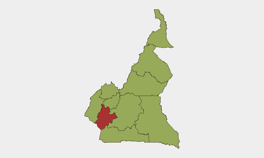
Littoral Region carries the highest composite risk score (79.3), driven by violent crime, trafficking networks, and port-related security pressures in Douala. The remaining nine regions cluster at 49.3, indicating that separatist conflict (Northwest, Southwest), Boko Haram–linked violence (Far North, Adamawa, North), and crime-facilitation corridors (Centre, East, South, West) are distributed across the country rather than concentrated in a single hotspot. Littoral's elevated score reflects both its economic centrality and its role as a transit hub for organized crime; Anglophone regions (Northwest, Southwest) sustain structural separatist risk; and Far North remains defined by jihadi-linked insurgency despite regional military operations.
How GeoBit Would Assist
Teams with personnel or assets in Cameroon should deploy AOI (Area-of-Interest) Monitoring & Early Warning on Littoral, Far North, and Anglophone provinces to generate automated alerts on new incidents before they mature into large-scale events. Multi-language OSINT (Intel Sweep, social media monitoring, regional press feeds) combined with temporal and sentiment analysis enables near-real-time detection of emerging unrest, criminal activity, or military action—critical given the current reporting lull and the risk of sudden escalation. Conflict & Military mapping, force-structure tracking, and Network & Actor Analysis support threat assessment and contingency routing for personnel movement in high-risk regions.
7-Day Outlook
No acute catalyst for immediate escalation is evident in the current reporting window, but the structural risks underpinning Cameroon's rank remain unchanged: Boko Haram operational tempo in Far North, separatist activity in Anglophone zones, and persistent organized crime. The reporting lull does not indicate reduced underlying threat; monitoring should remain active and contingency protocols should remain current for rapid personnel movement or asset protection if incident frequency accelerates.
Highest-Risk Areas — Ranked
| # | State / Region | Risk |
|---|---|---|
| 1 | Littoral | 79.3 |
| 2 | Northwest | 49.3 |
| 3 | Southwest | 49.3 |
| 4 | West | 49.3 |
| 5 | Adamawa | 49.3 |
| 6 | Centre | 49.3 |
| 7 | South | 49.3 |
| 8 | Far-North | 49.3 |
| 9 | North | 49.3 |
| 10 | East | 49.3 |
Sources
Previous Daily Briefs
A new Cameroon brief is written every day — each with its own risk map and downloadable CSV. Here's the last week; use the calendar to go further back.
📅 Browse every day by calendar →
Highlighted days have a brief. Tap a day for that day's map & analysis, or “csv” for that day's dataset ($5).
Atlas — our AI intelligence desk — emails them this snapshot personally. Nothing else, no list.