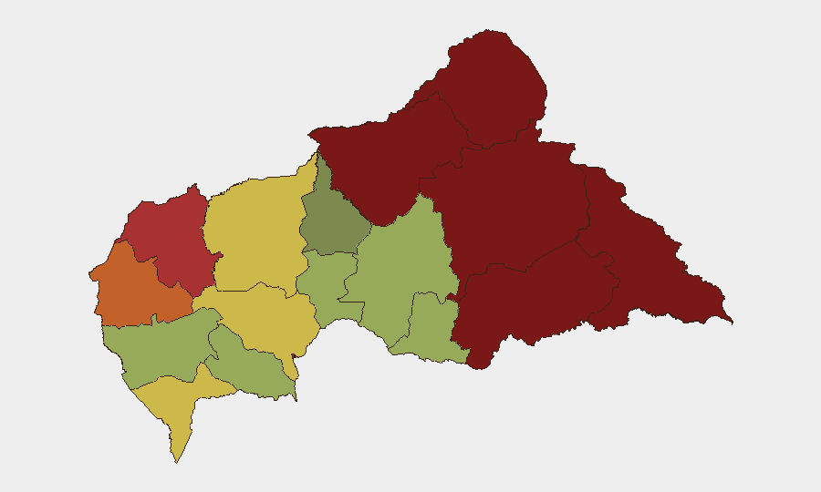
Situation Summary
Central African Republic remains classified as a high-risk operating environment (composite threat score 79, #32 globally) with chronic instability driven by armed group competition, weak state capacity, and limited administrative control outside Bangui. No verified security incidents have been reported in open sources over the last 24–48 hours; however, this reflects a significant reporting gap rather than operational quiet. The country's security posture is defined by persistent, geographically dispersed threat actors rather than discrete, time-stamped events detectable through standard OSINT channels.
Key Developments
No verified, geolocated security incidents with independent corroboration have been documented in Central African Republic in the last 24–48 hours (as of 2026-07-10 0600 UTC). Open-source reporting on CAR remains chronically sparse; granular incident data (specific locations, timestamps, event types) is typically unavailable in real time through international news outlets, X/Twitter, or regional security feeds. Organizations operating in CAR should not interpret absence of reported incidents as absence of threat—rather, as evidence of reporting constraints inherent to the operating environment.
Recent regional developments in neighboring states (Cameroon, Democratic Republic of Congo) show continued armed-group activity and border-region instability, patterns historically mirrored in northern and eastern CAR; however, no cascading cross-border incidents affecting CAR have been confirmed in the last 48 hours.
Highest-Risk Areas
Vakaga and Bamingui-Bangoran (risk scores 95 and 92 respectively) remain the highest-threat sub-national zones, driven by armed group presence, gold-mining competition, and proximity to Sudanese border dynamics. Haute-Kotto and Haut-Mbomou (88 and 85) present sustained risk due to banditry, trafficking networks, and weak government presence. The capital region of Bangui and surrounding Ombella-M'Poko (78 and 62) carry moderate-to-elevated risk concentrated on urban crime, political tensions, and access-control volatility. Northern and eastern prefectures should be treated as persistent denial-of-service zones for routine commercial and personnel operations without specialized security support.
How GeoBit Would Assist
Security teams should deploy AOI Monitoring & Early Warning on declared operational areas and transit routes, coupled with Intel Sweep (global event feeds, X/Twitter & Telegram OSINT) to capture real-time threat signals that may not appear in mainstream reporting. Network & Actor Analysis applied to armed-group messaging and financial flows can provide early indication of tactical shifts or escalation. Alternative route/journey planning (Routing & Network Analysis) and GIS & Spatial Analysis enable dynamic risk-based mobility decisions for personnel and asset movement. Closed-source feeds (UN SITREPs, NGO security networks) remain essential to supplement open-source gaps.
7-Day Outlook
Expect continued low-visibility, high-consequence operations by armed groups across Vakaga, Bamingui-Bangoran, and eastern prefectures with minimal advance warning through public reporting. Political and security tensions surrounding governance and resource access may escalate without clear incident precursors. No major escalation or nationwide event is predicted, but operational risk remains persistently elevated and difficult to quantify through conventional incident tracking.
Highest-Risk Areas — Ranked
| # | State / Region | Risk |
|---|---|---|
| 1 | Vakaga | 95 |
| 2 | Bamingui-Bangoran | 92 |
| 3 | Haute-Kotto | 88 |
| 4 | Haut-Mbomou | 85 |
| 5 | Mbomou | 82 |
| 6 | Ouham-Pendé | 79 |
| 7 | Bangui | 78 |
| 8 | Nana-Mambéré | 75 |
| 9 | Sangha-Mbaéré | 68 |
| 10 | Ouham | 65 |
| 11 | Ombella-M'Poko | 62 |
| 12 | Kémo | 58 |
Sources
Previous Daily Briefs
A new Central African Republic brief is written every day — each with its own risk map and downloadable CSV. Here's the last week; use the calendar to go further back.
📅 Browse every day by calendar →
Highlighted days have a brief. Tap a day for that day's map & analysis, or “csv” for that day's dataset ($5).
Atlas — our AI intelligence desk — emails them this snapshot personally. Nothing else, no list.