Situation Summary
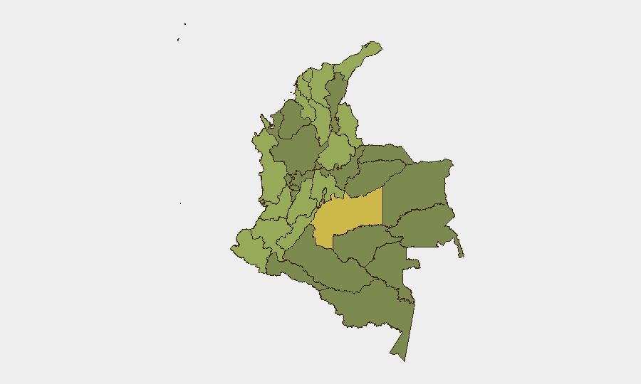
Colombia remains at composite threat level 31 globally (score 67) with 768 tracked events, reflecting persistent security fragmentation across multiple threat vectors—armed group activity, urban crime, and political transition dynamics. The security picture is defined by sharp regional variation: Meta Department (69.7) and the Capital District (46.9) dominate the risk profile, while southwestern departments (Cauca, Nariño, Huila) and the Venezuela border corridor (Norte de Santander) sustain elevated exposure to drone/bomb attacks and irregular armed group operations. The presidential transition period (election June 21, 2026; inauguration August 7) creates additional risk for protest activity and spontaneous civil disruption, particularly in major urban centers.
Key Developments
- Nationwide institutional activity (2026-07-14 to 2026-07-15): Multiple events tracked involving presidential statements, arrests/detentions by ministry and prison authorities, and investigative activity between inspector general and attorney general offices. No specific current threat incident has been time-verified in the past 24–48 hours; these signals reflect institutional and law-enforcement operational tempo rather than discrete security incidents.
- No confirmed security incidents in past 24–48 hours: Web research covering July 14–16, 2026 has not identified clearly dated, verifiable violent incidents, attacks, or civil unrest in the requested timeframe. Background: drone/bomb attacks in southwestern corridor (Cauca, Nariño, Huila) have been sustained since late April 2026; Tibú airport drone attack (Norte de Santander) occurred July 9, 2026.
- Heightened protest risk during government transition: Demonstrations and road blockades remain probable in Bogotá and other major cities ahead of August 7 inauguration, with potential for traffic disruption and localized clashes, particularly if policy announcements or political divisions emerge.
Highest-Risk Areas
Meta Department (69.7) and the Capital District (46.9) drive the composite ranking, with Meta reflecting persistent irregular armed group presence and territorial control challenges in the Llanos region. The southwestern corridor—Nariño (46.8), Cauca (42.8), Huila (42.9)—sustains elevated risk from sustained bomb and drone attacks attributed to non-state actors since late April 2026, compounded by guerrilla recruitment and logistics activity. Norte de Santander (45.0) and the Catatumbo region remain high-risk due to ELN activity, cross-border Venezuelan dynamics, and recent drone/explosive attacks on critical infrastructure. Collectively, these five departments account for the platform's highest alert levels and should be prioritized in corporate asset and personnel exposure mapping.
How GeoBit Would Assist
Security teams operating in Colombia should employ AOI Monitoring & Early Warning to establish persistent watch on Meta, the southwestern corridor (Cauca–Nariño–Huila), and Norte de Santander, with automated alerting for protest activity, armed clashes, and drone/attack events. Intel Sweep (multi-language OSINT fusion, social media analysis, radio SIGINT) provides real-time intelligence on ELN and non-state actor movements, protest planning, and institutional developments. Routing & Network Analysis enables duty-of-care teams to compute secure alternative routes for personnel and supply movements, particularly along the Panamericana and rural corridors, and Risk & Threat Assessment capabilities allow rapid scenario modeling as the government transition evolves.
7-Day Outlook
The presidential transition window through August 7 will likely see elevated protest activity in urban centers and continued baseline armed group operations in Meta and the southwestern corridor. Drone and bomb attack risk remains credible in Cauca, Nariño, and Huila. No major escalation is currently forecast, but organizational announcements or policy shifts on security/drug trafficking could trigger rapid shifts in protest intensity or armed group posture.
Highest-Risk Areas — Ranked
| # | State / Region | Risk |
|---|---|---|
| 1 | Meta Department | 69.7 |
| 2 | Capital District | 46.9 |
| 3 | Nariño | 46.8 |
| 4 | Norte de Santander Department | 45 |
| 5 | Santander Department | 44.4 |
| 6 | Huila Department | 42.9 |
| 7 | Cauca | 42.8 |
| 8 | Sucre Department | 42.2 |
| 9 | La Guajira | 41.8 |
| 10 | Bolívar Department | 41.2 |
| 11 | Atlántico Department | 41.1 |
| 12 | Tolima Department | 40.7 |
Sources
Previous Daily Briefs
A new Colombia brief is written every day — each with its own risk map and downloadable CSV. Here's the last week; use the calendar to go further back.
📅 Browse every day by calendar →
Highlighted days have a brief. Tap a day for that day's map & analysis, or “csv” for that day's dataset ($5).
Atlas — our AI intelligence desk — emails them this snapshot personally. Nothing else, no list.