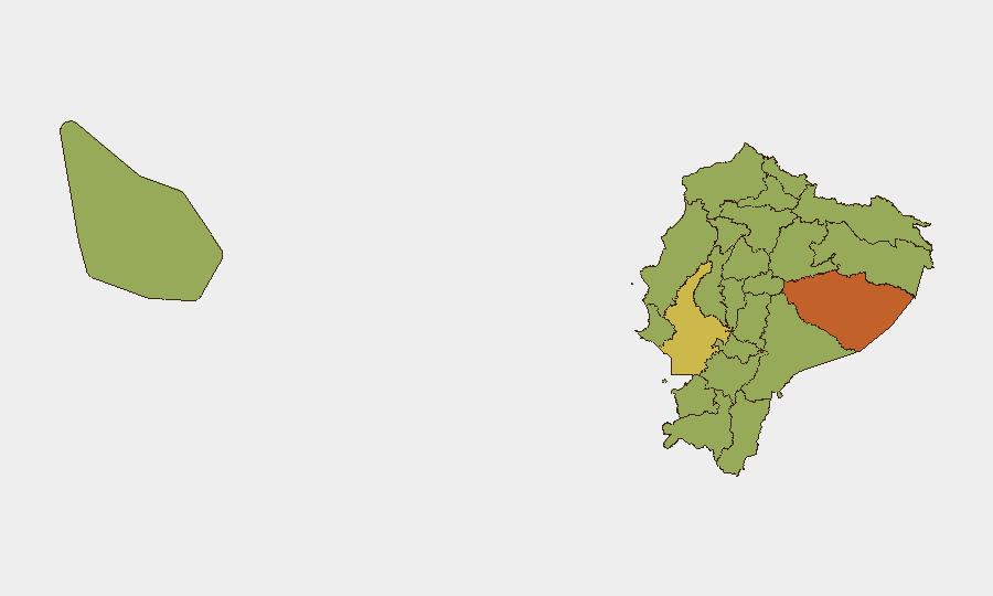
Situation Summary
Ecuador remains at composite threat level 35 globally (score 65), driven primarily by ongoing internal armed conflict and criminal-group competition for territorial and logistical control. Over the past 48 hours, armed attacks in coastal and urban centers (Manta, Guayaquil) have resulted in multiple fatalities, while nationwide state-of-exception measures continue to restrict movement and raise travel friction. The security environment shows no signs of de-escalation; gang clashes, weapons trafficking interceptions, and sporadic high-lethality incidents remain consistent across high-risk provinces.
Key Developments
- Manta, Manabí province (July 8, 2026): Armed assailants opened fire at a wake in the Santa Ana neighborhood early morning, killing four men and firing over 60 rounds. Police link the attack to ongoing criminal-group disputes in the province.
- Guayaquil, Guayas province (July 2026, recent days): Armed robbery attempt at a southern shopping mall resulted in a clash between assailants and security personnel, leaving two dead, one wounded, and one suspect apprehended.
- National (July 2026, ongoing): State-of-exception measures remain active across 12+ provinces including Pichincha (Quito), Guayas, Manabí, Sucumbíos, and Orellana, with intensified checkpoints, military patrols, and short-notice restrictions on airport and intercity transport.
- Amazon corridor, Sucumbíos region (July 2026): Security forces intercepted thousands of cartridges on public transport and seized explosives, grenades, and weapons linked to organized gangs, including Los Lobos, indicating active logistical disruption operations.
- Guayaquil, Guayas province (July 2026, recent): A 21-year-old woman was found decapitated on a public street; investigation underway with suspected links to micro-scale drug trafficking and prior offender apprehended.
- Quito (July 9, 2026): Approximately 100 family members of five private security guards who disappeared at sea in June held a protest at the national government seat, demanding intensified search efforts; one body recovered in Puerto Bolívar.
Highest-Risk Areas
Pastaza Province ranks highest (75.4), followed by Guayas (64.5), Orellana, and Zamora Chinchipe (both 50.5). Guayas and Manabí—home to Ecuador's major coastal ports and urban centers—drive risk through high-frequency gang violence, armed robberies, and maritime-linked organized crime. Pastaza, Orellana, Sucumbíos, and Napo in the Amazon region face insurgency activity, weapons trafficking, and limited state control, while Pichincha (Quito) remains elevated due to secondary effects of nationwide state-of-exception measures and urban gang presence. Organizations with personnel or assets in these provinces face acute risk from direct violence, movement restrictions, and investigative disruptions.
How GeoBit Would Assist
GeoBit's Intel Sweep and OSINT fusion capabilities enable real-time monitoring of public statements, law-enforcement activity, and gang-linked communications across X, Telegram, and regional news sources to anticipate localized violence. AOI Monitoring & Early Warning with persistent watch on Guayaquil, Manta, Quito, and Amazon-corridor transit routes provides immediate alerts when attack, trafficking, or security-force activity escalates. Routing & Network Analysis supports duty-of-care teams in identifying alternative travel corridors and safe-passage timing during state-of-exception lockdowns and checkpoint intensifications.
7-Day Outlook
Violent crime and gang competition are expected to remain elevated through mid-July, with state-of-exception enforcement continuing to disrupt routine movement. Risk of secondary clashes between security forces and criminal actors remains material, particularly in Guayas, Manabí, and Amazon provinces. Organizations should anticipate short-notice travel advisories and increased checkpoint delays affecting personnel and supply chains.
Highest-Risk Areas — Ranked
| # | State / Region | Risk |
|---|---|---|
| 1 | Pastaza Province | 75.4 |
| 2 | Guayas Province | 64.5 |
| 3 | Orellana Province | 50.5 |
| 4 | Zamora Chinchipe Province | 50.5 |
| 5 | El Oro Province | 47.3 |
| 6 | Pichincha Province | 46.6 |
| 7 | Napo Province | 46.6 |
| 8 | Imbabura Province | 46 |
| 9 | Sucumbíos Province | 45.4 |
| 10 | Manabí Province | 45.4 |
| 11 | Galápagos | 45.4 |
| 12 | Esmeraldas Province | 45.4 |
Sources
Previous Daily Briefs
A new Ecuador brief is written every day — each with its own risk map and downloadable CSV. Here's the last week; use the calendar to go further back.
📅 Browse every day by calendar →
Highlighted days have a brief. Tap a day for that day's map & analysis, or “csv” for that day's dataset ($5).
Atlas — our AI intelligence desk — emails them this snapshot personally. Nothing else, no list.