Situation Summary
Eritrea remains a low-frequency threat environment (rank #71 globally, 24/100 composite score) with no confirmed security incidents recorded inside the country over the last 24–48 hours. The primary security exposure identified in current reporting involves Eritrean-flagged maritime infrastructure rather than internal instability. Regional tensions involving Eritrean military posture toward Sudan and Ethiopia persist as a structural condition, but no discrete escalation has been documented since early August.
Key Developments
- Gulf of Aden, off Yemen – 20 August 2026 (confirmed 21 August):
Eritrean-flagged oil products tanker *M.T. Sibu 1* hijacked by approximately six armed pirates ~30 nautical miles off the Yemeni coast. Crew of 20 (predominantly Indian nationals, plus Syrian, Sudanese, Iraqi, and one unconfirmed nationality) reported safe under pirate control. Multi-source confirmation (Indian shipping ministry, regional media, international broadcasters) validates credible threat to Eritrean-flagged commercial shipping on this route.
- No verifiable internal security incidents – Eritrea (24–48 hour window):
Web research covering 20–21 August identified no corroborated reports of protests, civil unrest, crime spikes, clashes, or infrastructure sabotage within Eritrean territory (Asmara or provincial areas). The information environment remains opaque; absence of reporting reflects both low incident frequency and limited open-source media access.
Highest-Risk Areas
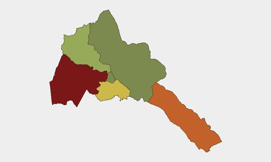
Gash-Barka region (composite risk 92) and Southern Red Sea Region (risk 75) dominate the sub-national threat landscape and are driven by cross-border armed group activity, smuggling networks, and proximity to Sudan's ongoing instability. Debub Region (risk 68) faces similar transnational pressures. By contrast, Maekel Region (which includes the capital, Asmara) carries minimal risk (18), and Northern Red Sea Region registers zero tracked risk. Organizations with personnel or assets in the western border zones and southern coastal areas should maintain heightened situational awareness relative to central and northern corridors.
How GeoBit Would Assist
Security teams managing Eritrean exposure should deploy AOI Monitoring & Early Warning on Gash-Barka and Southern Red Sea regions to detect cross-border armed group movement or unrest at earliest stages, coupled with Maritime & Aviation tracking to monitor Eritrean-flagged vessel movements and regional piracy patterns affecting commercial shipping. Intel Sweep (global event feeds, multi-language OSINT, entity extraction) and Network & Actor Analysis provide continuous visibility on Eritrean military posture, regime stability indicators, and smuggling networks that could affect duty of care. Routing & Network Analysis supports alternative journey planning around high-risk border zones for personnel movement.
7-Day Outlook
No significant change in Eritrea's internal security posture is anticipated over the next seven days absent new cross-border spillover from Sudan or Ethiopia. Maritime risk to Eritrean-flagged commercial traffic in the Gulf of Aden and Red Sea corridor will likely persist at current elevated levels given ongoing Houthi/piracy activity. Monitoring of the Gash-Barka region for any acceleration in armed group activity or refugee/displacement flows from Sudan should remain routine for risk teams.
Highest-Risk Areas — Ranked
| # | State / Region | Risk |
|---|---|---|
| 1 | Gash-Barka | 92 |
| 2 | Southern Red Sea Region | 75 |
| 3 | Debub Region | 68 |
| 4 | Anseba | 55 |
| 5 | Maekel Region | 18 |
| 6 | Northen Red Sea Region | 0 |
Sources
Previous Daily Briefs
A new Eritrea brief is written every day — each with its own risk map and downloadable CSV. Here's the last week; use the calendar to go further back.
- August 19, 2026
- August 17, 2026
- August 15, 2026
- August 13, 2026
- August 11, 2026
- August 9, 2026
- August 7, 2026
📅 Browse every day by calendar →
Highlighted days have a brief. Tap a day for that day's map & analysis, or “csv” for that day's dataset ($5).
Atlas — our AI intelligence desk — emails them this snapshot personally. Nothing else, no list.