Situation Summary
Ethiopia remains at elevated civil-conflict risk (global rank #11, composite threat score 90), driven primarily by ongoing armed fragmentation rather than acute incidents. As of 27 July 2026, no independently confirmed discrete security events have been verified in the last 24–48 hours across multi-source monitoring; however, the underlying structural risk—civil war, intercommunal tensions, and weak state authority across multiple regions—remains active. The security environment is characterized by chronic rather than acute instability, with significant geographic variance in threat intensity.
Key Developments
No independently confirmed security incidents meeting the 24–48 hour recency and cross-source verification threshold have been documented as of 27 July 2026. The most recent GeoBit event signals reference incidents from 24–25 July (diplomatic disapprovals by US and ICC Prosecutor; military-related business event) and ongoing disease surveillance alerts (Marburg virus, malaria), none of which constitute discrete tactical security incidents requiring immediate duty-of-care escalation. Travel advisories and conflict monitoring continue to reflect structural risks (armed groups, forced displacement, road insecurity in conflict zones) rather than newly activated incidents.
Highest-Risk Areas
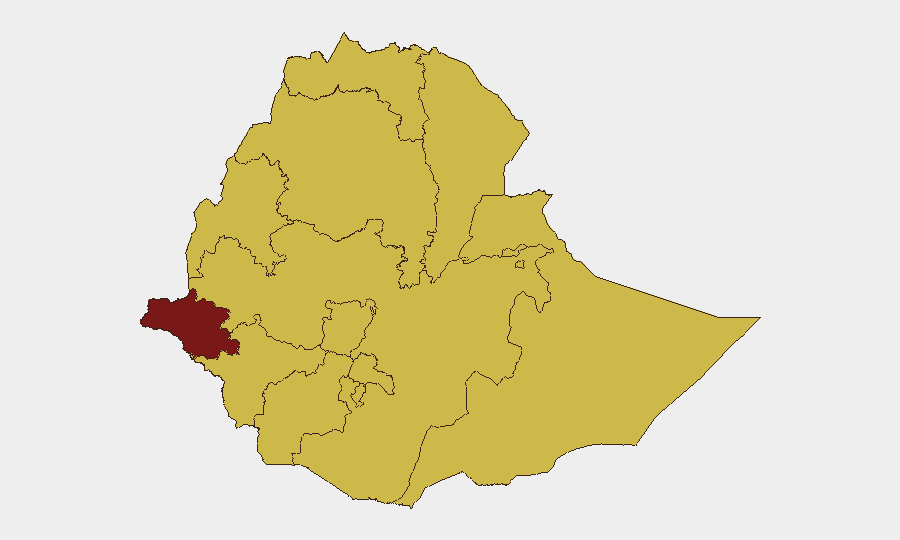
Gambela Region stands significantly apart, with a composite risk score of 92.8—substantially higher than all other sub-national units, which cluster at 62.8. This differential reflects acute armed-group activity, intercommunal violence, and weaker government presence. Tigray, Amhara, Afar, Benishangul-Gumuz, and Somali regions all share equally elevated baseline risk (62.8), driven by ongoing civil conflict, armed insurgencies, displacement, and limited humanitarian access since 2020. Even lower-risk zones including Addis Ababa, Oromia, and South Ethiopia Regional State maintain the same 62.8 score, indicating that conflict risk is geographically distributed and that the capital itself is not insulated from the national threat environment. Corporate operations and personnel in any of these zones should assume persistent civil-conflict and displacement risks.
How GeoBit Would Assist
Security and duty-of-care teams should deploy Intel Sweep and OSINT fusion to establish real-time multi-language monitoring of social media, local news, and radio SIGINT across high-risk regions, with automated corroboration to filter false signals. AOI (Area-of-Interest) Monitoring & Early Warning with persistent alerting on Gambela, Tigray, Amhara, and Somali regions will provide 24–48 hour lead time on escalations affecting supply chains and personnel movement. Routing & Network Analysis paired with satellite and GIS mapping enables dynamic alternative-route planning and safe-haven identification during movement restrictions or conflict expansion.
7-Day Outlook
No acute deterioration indicators are visible in the 24–48 hour window; however, persistent structural fragmentation and intercommunal tensions suggest that localized incidents remain probable in Gambela and the northern/eastern conflict zones within the next 7 days. Diplomatic activity (US/ICC Prosecutor statements) may trigger secondary tensions or enforcement actions. Personnel and asset managers should maintain elevated monitoring posture and assume road/access restrictions in high-risk regions remain in effect.
Highest-Risk Areas — Ranked
| # | State / Region | Risk |
|---|---|---|
| 1 | Gambela Region | 92.8 |
| 2 | Tigray | 62.8 |
| 3 | Amhara Region | 62.8 |
| 4 | Afar Region | 62.8 |
| 5 | Benishangul-Gumuz Region | 62.8 |
| 6 | Somali Region | 62.8 |
| 7 | South West Ethiopia Peoples | 62.8 |
| 8 | Addis Ababa | 62.8 |
| 9 | South Ethiopia Regional State | 62.8 |
| 10 | Central Ethiopia Regional State | 62.8 |
| 11 | Oromia Region | 62.8 |
| 12 | Sidama | 62.8 |
Sources
Previous Daily Briefs
A new Ethiopia brief is written every day — each with its own risk map and downloadable CSV. Here's the last week; use the calendar to go further back.
📅 Browse every day by calendar →
Highlighted days have a brief. Tap a day for that day's map & analysis, or “csv” for that day's dataset ($5).
Atlas — our AI intelligence desk — emails them this snapshot personally. Nothing else, no list.