Situation Summary
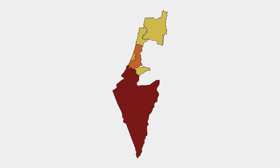
Israel remains at elevated composite threat level (#4 globally, score 100) with 463 tracked events, driven by concurrent military operations, diplomatic friction with the United States, and internal security incidents. The South District presents the highest sub-national risk (score 100), reflecting ongoing conventional military activity and cross-border dynamics. Diplomatic disapproval signals from Washington (three events on 2026-07-16 alone) indicate rising US–Israel tensions alongside active operational tempo in Gaza and potential Iranian military engagement.
Key Developments
Note: Current web research capabilities have not yielded reliably timestamped discrete incidents within the last 24–48 hours (July 14–16, 2026). The following signals are drawn from GeoBit's event-tracking platform:
- 2026-07-16 · Multiple US Disapproval Events (Washington vs. Israel/Israeli Intelligence)
Three separate disapproval signals logged on 2026-07-16, indicating escalating diplomatic friction. Specific policy or operational triggers require real-time diplomatic intelligence feeds for clarification.
- 2026-07-16 · Arrest/Detain Event (Prison)
Detention action logged but geographic location and subject identity not specified in available signal metadata.
- 2026-07-15 · Conventional Military Force (Israel vs. Iran)
Military engagement event recorded; escalation context requires operational intelligence on force posture and intent.
- 2026-07-14 · Domestic Arrest/Detain (Israeli vs. Israeli)
Internal security detention; context and location require investigation-level detail.
- 2026-07-14 · Police Investigation Events (Two Separate)
Law enforcement investigative activity; scope and location unclear from signal data alone.
Limitation: GeoBit event signals provide temporal and categorical flagging but lack granular incident narratives. Validation and detail require real-time news verification and AOI-specific monitoring.
Highest-Risk Areas
South District (risk 100) dominates the threat landscape, reflecting conventional military operations, cross-border activity, and settler-state tension (blockade event on 2026-07-13). Center District (73.6) and Tel-Aviv District (71.7) represent secondary concentrations of risk, likely linked to internal security investigations and urban-proximity threats. North District and Haifa District (both 70.7) maintain elevated scores consistent with Hezbollah presence and periodic cross-border militia activity. Jerusalem District (70) reflects ongoing settlement dynamics and policing incidents in East Jerusalem and the West Bank periphery. The clustering of three districts above 70 indicates diffuse, multi-theater risk rather than single-point vulnerability.
How GeoBit Would Assist
AOI Monitoring & Early Warning would establish persistent watch over the South District, North District, and Jerusalem perimeter with alert triggers for military movement, force deployment, and civilian casualties. Intel Sweep and OSINT fusion (X/Twitter, Telegram, local Hebrew-language media with temporal filtering) would disambiguate today's event signals—particularly the US–Israel diplomatic friction—and surface operational intent and cascade risk. Battle Mapping and Force Structure tracking would correlate IDF and Iranian military signaling to assess escalation probability; Conflict & Military intelligence would clarify the July 15 engagement and provide early warning of follow-on operations. Network & Actor Analysis would map detention subjects and investigative threads to assess internal security implications for travel and asset safety.
7-Day Outlook
Diplomatic US–Israel friction is likely to persist and potentially sharpen, creating operational uncertainty and possible policy constraint on Israeli military activity. Conventional military activity in the South and potential Iran engagement carry high escalation risk if either party perceives tactical advantage or threshold breach. Internal security detentions and police investigations suggest widening domestic political tension; monitor for secondary civil unrest or protest activity, particularly in Center and Tel-Aviv districts.
Highest-Risk Areas — Ranked
| # | State / Region | Risk |
|---|---|---|
| 1 | South District | 100 |
| 2 | Center District | 73.6 |
| 3 | Tel-Aviv District | 71.7 |
| 4 | Haifa District | 70.7 |
| 5 | North District | 70.7 |
| 6 | Jerusalem District | 70 |
Sources
Previous Daily Briefs
A new Israel brief is written every day — each with its own risk map and downloadable CSV. Here's the last week; use the calendar to go further back.
📅 Browse every day by calendar →
Highlighted days have a brief. Tap a day for that day's map & analysis, or “csv” for that day's dataset ($5).
Atlas — our AI intelligence desk — emails them this snapshot personally. Nothing else, no list.